
Graffiti on a fence, building or structure22 Godley 3
tagging on Christchurch city council concrete wall 22 Godley Quay Lyttelton
5,527 council reports since June 2015, the 23rd busiest suburb in the city. 4,587 photographs on record. About 3,220 people, Stats NZ’s June 2025 estimate for the wider Lyttelton urban area.
The record also holds about $600 a week to rent· 2023 Census snapshot· 4,587 photographs· 265 old photographs· 1 school· 16 parks· 4 civic facilities· 3 places of worship· 2 tracks· 28 names on the map· 1.6% of the outline mapped liquefied· 1.8% of the outline in the red zone· the record drew water over 1% of the outline· the mapped tsunami reach covers 13% of the outline· slope-hazard bands cover 26% of the outline· the Ngāi Tahu schedule covers 85% of the outline· landscape schedules over 42% of the outline· setback strips over 4% of the outline· 2,646 SCIRT photographs filed on this ground· 20 remembered names on this ground· 18 drawn rules bind this ground· 10 parcels on the dangerous-work register· 13 parcels of made ground· 1,023 surveyed rocks· 1 parcels with a cleanup on file· the 2019 model grades this ground mostly unlikely· 45 engineered defences· 75 council structures on the register· 7 recreation register records· 179 trees on the register· the plan’s word on this ground· 4% of the outline reserved· the plan’s exceptions touch 1% of the outline· 74 places on the heritage schedule· 28 epicentres inside the outline· 77 injury crashes· 533 recorded victimisations· 11 bus stops· 113 businesses· the council’s fix times· 75 heritage places· 40 documents· 5 mentions on the wire
Link-outs to the source’s own live pages, chch.live does not copy their live values or source text.
New bonds here ran at about $600 a week in the April–June 2026 quarter, the middle half of them between $473 and $640, across 24 bonds lodged, up 9% on a year ago. That’s about $50 a week above the city’s own quarter median of $550. Tenancy Services counts these under the “Lyttelton” statistical area, close to this suburb’s outline, not exactly it.
Median and quartiles of weekly rents on new private bonds, by quarter. New bonds are fresh lodgements, not the whole rental stock; under five bonds the rent is withheld, and counts are randomly rounded. Source: Tenancy Services rental bond data: provisional while the bond system migrates.
The ground: 2% of the outline went into the residential red zone; the February 2011 survey drew liquefaction over 2% of it, the rest of the watch is drawn further down.
Day to day it holds 1 school, 16 parks, 4 civic facilities, 3 places of worship, 2 tracks and 11 bus stops, each is counted further down.
Lately the record’s mostly graffiti & vandalism, 866 reports in the year to 13 October 2026, the newest 13 October 2026.
One for the quiz, Its busiest day on record was 7 January 2026, 72 reports in a single day.
About 3,117 people and 1,353 occupied private households in the “Lyttelton” statistical area, grouped from 19 SA1 areas. This exact statistical-area match is close to this suburb’s outline, not exactly it.
Ethnicity is a multiple-response measure, so those percentages are not meant to add to 100%.
Stats NZ’s 2023 Census uses fixed random rounding to base 3. Unavailable or confidential cells are left out, not treated as zero. individuals · households · geography · CC BY 4.0.
Lyttelton is a port town on the north shore of Lyttelton Harbour / Whakaraupō, on the eastern coast of the South Island of New Zealand. The town is separated from Christchurch by the Port Hills, an eroded remnant of the extinct Banks Peninsula Volcano.
Placed by the record’s locality join or the name in its own title, a lead, not a claim each frame stood here.
tagging on Christchurch city council concrete wall 22 Godley Quay Lyttelton

water leak, the whole street has had problems. time to repair properly instead of patch ups, especially when the council charging rate payers


Can we please have the shade sails put up now we are in Term 4 to support sun safety.

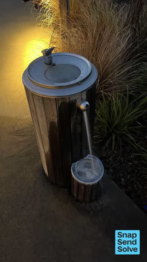
Fountain is stuck in the on position. From other posts and the very wet ground, it appears to have been going most of the weekend.


Swings in playground need oiling as they make an awful squeaking noise. Thanks v much.
The median council work order pinned in Lyttelton took 6 days to resolve, the city-wide median is 3 days, so this ground runs slower than the city as a whole. The slowest tenth waited 4 months or longer. 274 tickets are open here now, the oldest was filed 10 January 2020.
Work orders, not the resident reports above, the council’s MyCouncilTicket stream, and one job can appear in both. A median counts only finished jobs; open ones are named as open, never averaged in. The ticket roll · the whole city’s fix times.
One sensitive site stands here, Lyttelton Primary School, and the Local Alcohol Policy restricts new off-licences within 50 m of it.
The council’s bylaw zones and the Local Alcohol Policy’s buffer list, read from the Regulatory open-data service. A ban rules drinking in public places; it says nothing about whether a premises may sell, that is the licence register’s job.
Zoned for Christchurch Adventist School · Hillview Christian School · Lyttelton Primary School · Marian College · Middleton Grange School · St Anne's School (Woolston) · and 2 more zones, the drawn zone is indicative; the Ministry’s written scheme is the legal boundary.
Decile and EQI describe the community a school draws from, not how well it teaches.
The first eight of 16, Parks and reserves in the council’s open data, a park lands in the suburb its centre falls inside. The whole roll is at /parks.
Libraries, halls, cemeteries and the rest in the council’s open data, a facility lands in the suburb its point or centre falls inside. The whole shelf is at /facilities.
Places of worship in the open map’s record, one lands in the suburb its building stands in. The whole roll is at /worship.
Tracks in the council’s open data, a line belongs to every suburb it passes through. The whole network is at /tracks.
The February 2011 survey drew mapped ground failure over 1.6% of this outline, about 10 hectares. A patch is a footprint, not a finding about an address; the count for the whole city is at /liquefaction.
The Crown’s 2011 classification drew 1.8% of this outline, about 11 hectares inside the residential red zone. A mapped area files under the suburb its middle sits in, and a classification is the record of a decision, not a finding about an address; the whole line is drawn at /redzone.
The flood record drew water over 1.0% of this outline, about 6 hectares, across 1 named event. A patch is one event’s observation, not a live hazard finding; the whole record is drawn at /floods.
The mapped tsunami extent covers 13% of this outline, about 78 hectares. The sea’s modelled reach, not a prediction, the plan’s inundation line, not the evacuation zones; the share is read from a sampled join. The whole extent is drawn at /tsunami.
The plan’s slope-hazard bands cover 26% of this outline, about 166 hectares, rockfall management area 1, rockfall management area 2, cliff collapse management area 2. The broad remaining-instability overlay covers 57% of it besides, the plan’s background watch over the hill country. Shares read from a sampled join; a management overlay, not a prediction. The whole watch is drawn at /slope.
10 parcels inside this outline sit on the hazardous-activities register, mostly vehicle refuelling, service and repair, chemical manufacture, application and bulk storage, mineral extraction, refining and reprocessing, storage and use, 9 still doing the work. A listing records the work, not a soil test; the whole register is drawn at /hazards.
The files record 13 parcels of made or characterised ground inside this outline, mostly mixed fill with demolition material, gravel, 3 carry fill the file can’t vouch for. A record is the file’s word on what was laid, not a fresh survey; the whole layer is drawn at /fill.
The rockfall survey mapped 1,023 rocks inside this outline across 419 survey pins, 612 came down, 48 still wobble easy. A pin may stand for a cluster and marks where the survey saw the rock, not where it is now; the whole survey is drawn at /boulders.
1 parcel inside this outline carries a cleanup on the file. A cleanup on the file is the register’s word, not a clearance; the whole register is drawn at /remediated.
The 2019 liquefaction study put 1% of this outline in the "unlikely" class, 1% of the outline fell inside an assessed area. A class is the model’s verdict on a patch of ground, not a finding about an address; the whole study is drawn at /vulnerability.
The register puts 45 engineered rockfall defences inside this outline, 36 rock anchors, 5 catch fences, 3 mesh drapes, 4 rated poor or worse on the file. Nearly all are the emergency works the quake years left standing; the whole register is drawn at /defences.
The council’s structure register stands 75 assets on this ground, 61 sets of steps, 5 ramps, 5 shelters, 3 boat ramps, sited at Lyttelton Cemetery, Park Terrace Reserve, Lyttelton Recreation Centre, Albion Square. The register’s site names are its own labels for the ground an asset stands in; the layer is drawn at the map.
The recreation register keeps 7 records inside this outline, bookable surfaces for 2 basketball, 2 football, 2 rugby, 1 skateboard. Seasons and surfaces are the register’s record, not this week’s draw; the layer is drawn at the map.
The register counts 179 living trees inside this outline, 5 veterans among them, 2 carrying a protection, mostly Sycamore, Cabbage tree, English Oak. The file remembers 51 trees felled here. A tree record is the register’s word on what stands or stood; the whole canopy is drawn at /trees.
The plan files 27% of this outline under Open Space Natural, 15% residential, the rest mostly Specific Purpose (Lyttelton Port) 24%, Residential Banks Peninsula 15%. A zone is a permission, not a description, the mix is read from a sampled join of the plan’s polygons; the whole district is drawn at /zones.
The plan reserves about 22 hectares of this outline, 4%, under 5 designations, mostly movement, pipes. A designation is a claim on the ground, not a build date, the mix is read from a sampled join; the whole register is drawn at /designations.
The plan’s exceptions touch 1% of this outline, 1 qualifying matter, mostly heritage. A matter narrows how the density rule applies, it does not forbid; the mix is read from a sampled join, and the cultural-significance areas are the plan’s own unnamed ones. The whole register is drawn at /matters.
The plan’s heritage schedule protects 74 places by name in this suburb, 15 graded highly significant, Battery Point Battery, Bridle Path, Commercial Building and Setting, Former Maher's Drapery among them. And the street itself is listed, the Lyttelton heritage area lies here, protected as a street rather than house by house. A setting is the ground the item stands in, each files under the suburb holding its centroid; the whole schedule is at /heritage.
The plan’s schedule of sites significant to Ngāi Tahu covers 85% of this outline, about 532 hectares, ngā tūranga tūpuna, ngā wai. Shares read from a sampled join; a recognition overlay, not a catalogue. The whole schedule is drawn at /cultural.
The plan’s landscape schedules cover 42% of this outline, about 261 hectares across 8 scheduled areas, 24% of it outstanding, the plan’s strongest landscape standing, and 38% of it sits inside the coastal environment. Shares read from a sampled join; a protection overlay, not a ranking of views. The kept view is drawn at /landscape.
The plan’s water-margin layers cross this outline, 14 classified reaches, 4% of it inside the setback strips, the widest holding 20 m off the bank, and an esplanade line holds a public edge here. The margin is the plan’s drawing, not a survey of the bank; the reaches, strips and held edges are mapped at /water-margin.
The plan’s allowed shape holds this outline, 1 hill density line holds the high ground low. The shape is the plan’s permission, not a survey of what stands; the allowed shape is drawn at /density.
The rebuild’s cameras filed 2,646 photographs on this ground, 2010–2017, wastewater work mostly. Each frame is a receipt the dig left behind, a work log, not a survey of what stands now; the whole record is drawn at /rebuild.
The remembered names stand on this ground, 20 inscribed plaques, Sumner Road Gardens, Oxford Street Reserve, Sutton Reserve among the grounds. The plaque is the register’s pin, not a surveyed spot; the whole roll is kept at /plaques.
The rulebook binds this ground, 18 drawn instruments, 13 of them dog rules, 4 camping zones, a certified self-contained van can stay the night at Christchurch Urban Restricted Area and Naval Point Freedom Camping Area; the other 2 zones ban it outright, 1 bottle-store buffer; the outline sits inside the takiwā of Rapaki Runanga and Te Ngai Tuahuriri Runanga. The bylaw is the instrument, this the map of it, the whole rulebook is drawn at /rules.
GeoNet’s catalogue puts 28 magnitude-3+ epicentres inside this outline since the sequence opened, the biggest a M4.1 in 2011. An epicentre is where the instruments placed the break, not a measure of the shaking here; the whole catalogue is counted at /sequence, the live record is /quakes, and the story in plain language is the earthquakes explainer.
The named waterways, bays, headlands, monuments, summits and old sites OpenStreetMap puts inside this outline, a pin is the mapper’s own; a waterway belongs to every suburb it crosses. Every roll, counted: /geography.
77 crashes that hurt somebody on record inside Lyttelton's outline, 2 people killed, 22 seriously hurt.
The corner that keeps appearing: Sumner Road at Dump, 12 injury crashes, 1 fatal.
533 victimisations on the Police record inside Lyttelton’s outline, September 2022–August 2026, mostly theft, about 43 a year per 1,000 residents. Down 19% on the year before. Reported is not all, how much never reaches the record depends on the offence.
11 Metro stops inside Lyttelton's outline, in ECan’s stop record, served by route 8, route 155, the Diamond Harbour ferry.
113 premises in Lyttelton across 48 kinds, from OpenStreetMap, the council’s licensed-premises register and its 2024 Find Christchurch directory. Each kind below opens at this suburb’s shelf.
Among them, the ones the record says most about:
What the archive’s sources say about Lyttelton, titled for it, turned up by a search for one of its places, or carrying its name in the text. These are leads and citations: the originals live at the provider, linked from each row.
…'Christchurch, N.Z. 1852-1921', comprising 49 black and white prints of Christchurch and Lyttelton scenes as they appeared in the mid-nineteenth century and in 1919. Photographs / He Whakaahua; Albu…Photographs / He Whakaahua · Kura Heritage Collections Online · Auckland Libraries ·
Exterior view of the original Holy Trinity Church at Lyttelton, built of wood and brick in 1852. The green timber shrank, making the church unsafe in high wind, it…Photographs / He Whakaahua · Kura Heritage Collections Online · Auckland Libraries ·
…try. DESCRIPTION: On 2 June 1851 the Reverend Benjamin Woolley Dudley, who had arrived in Lyttelton as chaplain on board the 'Cressy' in 1850, purchased 50 acres of rural land (Rural Section 40) from…The New Zealand Heritage List/Rārangi Kōrero · Heritage New Zealand Pouhere Taonga · 1851
…thcote this means of communication between the port and the plain issues from the town of lyttelton just to the west of the custom-house reserve norwich quay having been made per fectly passable for c…Lyttelton Times · Papers Past · National Library of New Zealand · · text held
…12 c to the market-place at christchureh is about 3 and to riccarton nearly 4 miles from lyttelton it is thus whether by the path on the top or by that aiong the foot of the hills about 8 miles to ch…Lyttelton Times · Papers Past · National Library of New Zealand · · text held
…several large window-frames with casements glazed complete apply to mr e dobson surveyor lyttelton nb wanted to purchase two strong navies narrows on sale patent galvanized corrugated tp on for hoofi…Lyttelton Times · Papers Past · National Library of New Zealand · · text held
…obtained provisions of every description hardware tools nails earthenware c agent for the lyttelton times market-place christchurch jan 31 1851 for sale a saddle mare 15 hands high c3p or particulars…Lyttelton Times · Papers Past · National Library of New Zealand · · text held
…thcote this means of communication between the port and the plain issues from the town of lyttelton just to the west of the custom-house reserve norwich quay having been made perfectly passable for ca…Wellington Independent · Papers Past · National Library of New Zealand · · text held
…ion is to be adhered to as closely as possible no 1 maria somes fifty acre section in the lyttelton district commencing at the end of jackson street and proceeding in a north direction in the same lin…Lyttelton Times · Papers Past · National Library of New Zealand · · text held
The rest are a search away, the whole shelf, for the name →
1,778 more documents came up in searches for Lyttelton's places and have not been read yet, a lead is a search result, not a fact, until somebody reads it.
Compare Lyttelton with Corsair Bay · Cass Bay · Heathcote Valley · Diamond Harbour · Rapaki · Mount Pleasant, same record, side by side.
Lyttelton is a port town on the north shore of Lyttelton Harbour / Whakaraupō, on the eastern coast of the South Island of New Zealand. The public record holds 5,527 council reports for it, the first filed in June 2015.
About 3,220: Stats NZ’s June 2025 estimate for the wider Lyttelton urban area, 513 per square kilometre across 6.3 km².
About 3,117 people and 1,353 occupied private households: grouped from Stats NZ SA1 areas through this site’s suburb join. Indicative, not a LIM.
5,527 reports on record, most often graffiti & vandalism (1,982), water & drains (1,186), roads & footpaths (1,085). 866 of them in the year to 13 October 2026.
77 injury crashes on the police record inside the suburb’s outline, 2 people killed, 22 seriously hurt. The suburb’s crashes, mapped →
GeoNet’s catalogue puts 28 magnitude-3+ epicentres inside the suburb’s mapped outline since the September 2010 mainshock, the biggest a M4.1 in 2011. An epicentre is where the instruments placed the break, not a measure of the shaking felt here. The whole sequence, counted → · The story, in plain language →
Every suburb in Christchurch → · Its decade, charted → · the whole A–Z →
Work orders, not the resident reports above, the council’s MyCouncilTicket stream, and one job can appear in both. A median counts only finished jobs; open ones are named as open, never averaged in. The ticket roll · the whole city’s fix times.
The council’s bylaw zones and the Local Alcohol Policy’s buffer list, read from the Regulatory open-data service. A ban rules drinking in public places; it says nothing about whether a premises may sell, that is the licence register’s job.
Ministry of Education directory, the final decile and the current Equity Index describe the community a school draws from, not how well it teaches. Zones are indicative; the written enrolment scheme rules.
Parks and reserves in the council’s open data, the park lands in the suburb its centre falls inside; one that straddles the line keeps its own address.
Libraries, halls, cemeteries and the rest in the council’s open data, a facility lands in the suburb its point or centre falls inside.
Places of worship in the open map’s record, one lands in the suburb its building stands in. The whole roll is at /worship.
Marae in the region’s roll, a marae stands where it stands; the join names the suburb the roll files it under. The whole roll is at /maraes.
Walking, biking, horse and off-road tracks in the council’s open data, a line belongs to every suburb it passes through.
OpenStreetMap’s own record, inside this outline, a pin is the mapper’s; a waterway belongs to every suburb it crosses. Every roll, counted: /geography.
Heritage places the council’s district plan or Heritage New Zealand list inside this suburb, each with what is known about it and the document it is known from.
The register’s era records for places in this suburb, what stood on the ground, and when.
Each of these is a decade of reports, the heritage places on the register, what is known about them, and the documents behind it, everything the archive holds about the part of the city it names.