122 Wigram Road, Wigram
39 reports on record since February 2019 · 33 with photographs. The most-reported address on Wigram Road. Indicative rating valuation and school zones, hazards, bin day and what stood here before.
What gets reported here
- Roading/Streets — 9
- Graffiti — 9
- Dumped Rubbish — 7
- Overgrown Vegetation — 4
- Roads - General — 2
- Pavement - Damaged — 2
Photographed here 33 on record


Reported here
 Overgrown Vegetation —
 Overgrown flaxes going to the pathway
 Roads - General —
 gravel is extended across roadway
 Overgrown Vegetation —
  Damaged Street Light —
 Street light lantern is tilted sideways at an angle. Located on Wigram Road opposite the intersection with Hayton Road
 Pavement - Damaged —
 Footpath not sealed
 Overgrown Vegetation —
 Overgrown vegetation blocking footpath
 Pavement - Damaged —
 Footpath wasn't sealed after works
 Graffiti somewhere else —
 Walkway across the road from Enotel
 Roads - General —
 Hey, wondering if I could put on the radar a safe crossing point for cyclists / pedestrians Accross Wigram road when using the motorway unde
 Overgrown Vegetation —
 These weeds are making the cycle way unsafe
 Graffiti —
  Dumped Rubbish —
 Rubbish bags and mattress dumped on gravel area off Wigram Rd.
 Dumped Rubbish —
  Dumped Rubbish —
  Dumped Rubbish —
 Two large bags of rubbish on shingle area opposite Hayton rd, off Wigram rd.
 Graffiti —
 At entrance to tunnel under motorway by showgrounds
- Dumped Rubbish —
- Dumped Rubbish —
- Dumped Rubbish —
- Damaged Street Sign —
- Road Signage —
- General Request —
 Street Light Outage —
 Street lights in the underpass need replacing
 Graffiti —
 Graffiti near the artwork in the underpass
 Graffiti —
 Graffiti near the artwork in the underpass
 Graffiti —
 Graffiti near the artwork in the underpass
 Graffiti —
 Graffiti near the artwork in the underpass
 Graffiti —
 Graffiti near the artwork in the underpass
 Graffiti —
 Graffiti on the artwork in the underpass
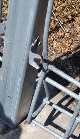 Roading/Streets —
 The fencing next to the highway is damaged and disconnected at various points. This is a safety issue as dogs and small children can get th
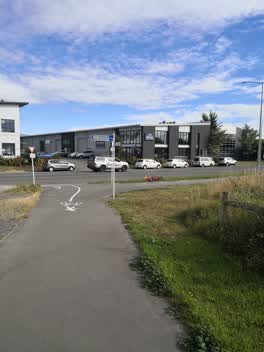 Roading/Streets —
 Cycling directional sign is pointing the wrong way.
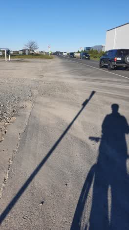 Roading/Streets —
 Gravel on roadway where cars and bikes move left to avoid the stationary cars turning right into hayton rd
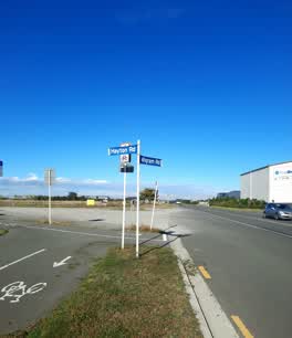 Roading/Streets —
 can a foot path or cycle track continue on Wigram Road to meet up with the one further along
Graffiti —
Roading/Streets —
This is a walkway/cycleway used by many people daily,next weekend a half marathon will run on this same ww/cw. This is a fairly serious "saf
Roading/Streets —
Overgrowth blocking cycleway causing cyclists to pass on narrow trail.
Roading/Streets —
Gravel needs to be swept from the cycleway - this is dangerous to cyclists.
Roading/Streets —
There is excess of gravel and stones on this cycleway preventing safe use by Rollerbladers. Any chance it could be kept clean? Many thanks i
Roading/Streets —
This cycle Lane has confusing and contradictory signs. A give way and stop sign are 2 meters apart. Another sign indicates to turn right yet
Also reported on Wigram Road
- 124 Wigram Road — 15 reports
- 92 Wigram Road — 8 reports
- 306 Wigram Road — 6 reports
- 291R Wigram Road — 6 reports
- 82 Wigram Road — 5 reports
- 243A Wigram Road — 5 reports
- 187 Wigram Road — 5 reports
- 101 Wigram Road — 5 reports
The street’s crash record
NZTA’s record names Wigram Road in 19 crashes that hurt somebody since 2006 — 5 seriously hurt, nobody killed.
The green nearby
- Nga Puna Wai North — you are in it · Sports ground · 11 ha
- Hayton Stream 2 Drainage Reserve — 90 m to the edge · 3 ha
- Nga Puna Wai — 180 m to the edge · Sports ground · 83 ha
Parks within half a kilometre, measured to the boundary — the council’s open data.
On the doorstep
- CoolDrive — 96 m away · Car parts
- Ash Air — 138 m away · Trade
- Curtis Vision — 138 m away · Optometrists
- Inex Metals — 146 m away · Trade
Businesses within four hundred metres, measured at the pin — OpenStreetMap and the council directories.
The tracks through here
- Walk and bike track through Wigram — 14 m to the line · walk · bike
- Walk and bike track through Wigram — 386 m to the line · walk · bike
Tracks whose line passes within half a kilometre, measured to the line itself — the council’s open data.
The named ground
Named water within 500 m of this address, measured to the line or the edge; Named places within 1.5 km of this address — the open map’s record.
Renting nearby
new bonds in Wigram ran about $697 a week — $147 above the city median of $550 — the suburb page keeps the rent record →.
The civic layer
This ground votes in Halswell ward — the Halswell-Hornby-Riccarton community board. Ward lines don’t always follow suburb lines; this one is measured at the pin, not the suburb’s centre.
What stood on this ground → · On the map → · From the air — the Crown’s aerials back to 1936; search the address on RetroLens →
Questions, answered briefly
39 council reports on record since February 2019 — most often roading/streets (9), graffiti (9), dumped rubbish (7).
Wigram, Christchurch — on Wigram Road.
Nothing on the heritage register at this exact spot — the record around this ground →
Nga Puna Wai North — the address is inside it, 11 ha.