140 Smith Street, Woolston
45 reports on record since June 2015 · 30 with photographs. The street’s heaviest record is 180 Smith Street — 218 reports on file. Indicative rating valuation and school zones, hazards, bin day and what stood here before.
What gets reported here
- Dumped Rubbish — 14
- Overgrown Vegetation — 6
- Rubbish/Recycling — 4
- Graffiti — 4
- General - Abandoned Trolley — 3
- Parks — 2
Photographed here 30 on record




Reported here
 Dumped Rubbish —
 Wooden rubbish thrown in creek
 Roads - General —
 Bike track damage path
 Pavement - Damaged —
 Tree roots under path
 Dumped Rubbish —
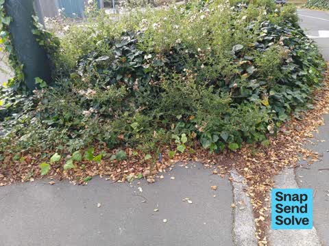
  Overgrown Vegetation —
 overgrown thistles and ivy
 Accessibility —
 these tgsi are incorrectly installed they are too close to the kerb and are not aligned to the path of travel
 Dumped Rubbish —
 ru
 Dumped Rubbish —
 There is a printer and boxes dumped on the side of the road near the community garden fence on smith street. Abonded rubbish
 Overgrown Vegetation —
 Old man’s beard over Linwood Drain. It is flowering and taking over trees
 Park - General Request —
  Overgrown Vegetation —
 Shoulder high weeds in ccc roadside garden bed
 Dumped Rubbish —
 A double mattress has been dumped on the grass verge on the park side of smith street near the tennis courts Is it possible to get cameras
 General Request —
 would it be possible to have the grass cut on the verges of 140 smith street and 138 smith street the occupants do not seem to care or do no
 Dumped Rubbish —
 numerous old tyres have appeared to be dumped on smith street next to the community gardens opposite the tennis courts
 Dumped Rubbish —
 Dumped rubbish outside 140 smith st , woolston
 Graffiti somewhere else —
 Graffiti tree
 Water General —
 Missing Toby cover
 Graffiti somewhere else —
 Tree and board along walk way has graffiti on it
 Graffiti —
  Street Gutters / Storm Water —
 This drain needs e a good clean out please
 Litter —
 Someone has dumped a suitcase on the side of smith street at the end of the pools carpark across from the community gardens empty suitcase
- Dumped Rubbish —
- Dumped Rubbish —
- Dumped Rubbish —
- Dumped Rubbish —
- Dumped Rubbish —
- Dumped Rubbish —
- Graffiti —
- Dumped Rubbish —
- Overgrown Vegetation —
- Graffiti —
- Overgrown Vegetation —
- Overgrown Vegetation —
- General - Abandoned Trolley —
- General - Abandoned Trolley —
- General - Abandoned Trolley —
 Parks —
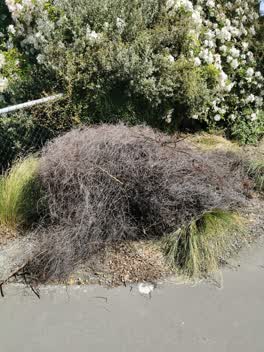
 Green waste left by contractors
 Graffiti - Public Property —
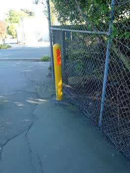
 entrance to walkway
Rubbish/Recycling —
Rubbish/Recycling —
Parks —
The entrance to Linwood Park here is dangerous for cyclists. The central bollard means cyclists going into the park have to go at a sharp an
Roading/Streets —
How much longer does this TV have to stay about 300 meters from Smith Street yard
Rubbish/Recycling —
TV just down road from Smith St service centre
Rubbish/Recycling —
Graffiti —
Also reported on Smith Street
- 180 Smith Street — 218 reports
- 117 Smith Street — 81 reports
- 119 Smith Street — 38 reports
- 8 Smith Street — 35 reports
- 19P Smith Street — 29 reports
- 141 Smith Street — 26 reports
- 18 Smith Street — 13 reports
- 130 Smith Street — 12 reports
The street’s crash record
NZTA’s record names Smith Street in 18 crashes that hurt somebody since 2006 — 3 seriously hurt, nobody killed.
The green nearby
- Linwood Park — 19 m to the edge · Sports ground · 9 ha
- Linwood Nursery — 19 m to the edge · 1 ha
- Linwood Esplanade Reserve — 239 m to the edge
- Arran Playground — 406 m to the edge
Parks within half a kilometre, measured to the boundary — the council’s open data.
The civic shelf nearby
- Linwood Service Centre — 468 m away · Service centre
Libraries, halls and the rest within half a kilometre — the council’s open data.
On the doorstep
- Linwood Pool: Te Pou Toetoe — 168 m away · Sports centres
- Linwood Ave Rotary Market — 334 m away · Markets
Businesses within four hundred metres, measured at the pin — OpenStreetMap and the council directories.
The bus nearby
- Eastgate Mall (Linwood Ave) — 316 m away · route 140
- Linwood Ave near Tilford St — 337 m away · route 140
The closest Metro stops, within four hundred and fifty metres.
The tracks through here
- Walk and bike track through Woolston — 36 m to the line · walk · bike
- Walk and bike track through Woolston — 50 m to the line · walk · bike
- Walk and bike track through Woolston — 136 m to the line · walk · bike
- Walk and bike track through Woolston — 156 m to the line · walk · bike
- Walk and bike track through Woolston — 228 m to the line · walk · bike
Tracks whose line passes within half a kilometre, measured to the line itself — the council’s open data.
The named ground
the council’s own structure register — bridges, boardwalks and steps standing nearby — the open map’s record.
The remembered names nearby
- Christchurch City Council / Parks and Recreation Depot — 116 m away ·
CHRISTCHURCH CITY COUNCIL / PARKS AND RECREATION DEPOT / OFFICIALLY OPENED BY / THE MAYOR
· 1899 - This Tree Was Planted to Commemorate the Coronation — 186 m away ·
This tree was planted to commemorate the coronation of H.M. Elizabeth II 1953
· 2009
Inscribed plaques within two hundred and fifty metres — the register’s pins, not surveyed spots. The whole roll is at /plaques.
Renting nearby
new bonds in Woolston ran about $511 a week — $39 below the city median of $550 — the suburb page keeps the rent record →.
The civic layer
This ground votes in Linwood ward — the Coastal-Burwood-Linwood community board. Ward lines don’t always follow suburb lines; this one is measured at the pin, not the suburb’s centre.
What stood on this ground → · On the map → · From the air — the Crown’s aerials back to 1936; search the address on RetroLens →
Questions, answered briefly
45 council reports on record since June 2015 — most often dumped rubbish (14), overgrown vegetation (6), rubbish/recycling (4).
Woolston, Christchurch — on Smith Street.
Nothing on the heritage register at this exact spot — the record around this ground →
Linwood Park — 19 m to its edge, 9 ha.