141 Smith Street, Woolston
26 reports on record since June 2015 · 23 with photographs. The street’s heaviest record is 180 Smith Street — 218 reports on file. Indicative rating valuation and school zones, hazards, bin day and what stood here before.
What gets reported here
Photographed here 23 on record




Reported here
 Graffiti on a fence, building or structure —
 Graffiti on railing
 Graffiti on a sign, mural or public art —
 Graffiti on pool sign
 Graffiti on a fence, building or structure —
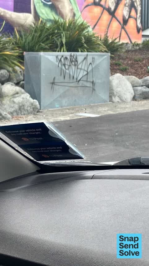
 Graffiti on steel box outside Linwood pool
 Graffiti somewhere else —
  Vandalism - General —
 Multi tags on cream wall
 Graffiti on a fence, building or structure —
 On side wall of council building on Smith Street
 Graffiti on a fence, building or structure —
  Graffiti on a fence, building or structure —
  Water General —
 Is this a broken cover to a water tap? Dangerous anyway
 Graffiti somewhere else —
  Graffiti somewhere else —
  Graffiti somewhere else —
 Utility outside Smith Street Council building has graffiti on it
- Water Leak —
- Dumped Rubbish —
- Dumped Rubbish —
 Graffiti —
 Parks —
No toilet roll in the Linwood park 252
Graffiti —
Graffiti —
Parks —
This needs trimming as well
Parks —
What's happening with the toilet block both locked today Can we at least try and get both open together. I thought armourguard did it needs
Roading/Streets —
Trailer load of branches dumped on roadside
Graffiti —
Graffiti —
Rubbish/Recycling —
More matresses
Rubbish/Recycling —
Also reported on Smith Street
- 180 Smith Street — 218 reports
- 117 Smith Street — 81 reports
- 140 Smith Street — 45 reports
- 119 Smith Street — 38 reports
- 8 Smith Street — 35 reports
- 19P Smith Street — 29 reports
- 18 Smith Street — 13 reports
- 130 Smith Street — 12 reports
The street’s crash record
NZTA’s record names Smith Street in 18 crashes that hurt somebody since 2006 — 3 seriously hurt, nobody killed.
The green nearby
- Linwood Park — 36 m to the edge · Sports ground · 9 ha
- Linwood Nursery — 36 m to the edge · 1 ha
- Linwood Esplanade Reserve — 230 m to the edge
Parks within half a kilometre, measured to the boundary — the council’s open data.
The civic shelf nearby
- Linwood Service Centre — 389 m away · Service centre
Libraries, halls and the rest within half a kilometre — the council’s open data.
On the doorstep
- Linwood Pool: Te Pou Toetoe — 54 m away · Sports centres
- Linwood Ave Rotary Market — 279 m away · Markets
- On The Go — 327 m away · Car repair
- KFC — 346 m away · Fast food
Businesses within four hundred metres, measured at the pin — OpenStreetMap and the council directories.
The bus nearby
- Eastgate Mall (Linwood Ave) — 249 m away · route 140
- Linwood Ave near Tilford St — 282 m away · route 140
The closest Metro stops, within four hundred and fifty metres.
The tracks through here
- Walk and bike track through Woolston — 103 m to the line · walk · bike
- Walk and bike track through Woolston — 125 m to the line · walk · bike
- Walk and bike track through Woolston — 133 m to the line · walk · bike
- Walk and bike track through Woolston — 133 m to the line · walk · bike
- Walk and bike track through Woolston — 146 m to the line · walk · bike
Tracks whose line passes within half a kilometre, measured to the line itself — the council’s open data.
The named ground
the council’s own structure register — bridges, boardwalks and steps standing nearby — the open map’s record.
The remembered names nearby
- Christchurch City Council / Parks and Recreation Depot — 30 m away ·
CHRISTCHURCH CITY COUNCIL / PARKS AND RECREATION DEPOT / OFFICIALLY OPENED BY / THE MAYOR
· 1899 - This Tree Was Planted to Commemorate the Coronation — 152 m away ·
This tree was planted to commemorate the coronation of H.M. Elizabeth II 1953
· 2009
Inscribed plaques within two hundred and fifty metres — the register’s pins, not surveyed spots. The whole roll is at /plaques.
Renting nearby
new bonds in Woolston ran about $511 a week — $39 below the city median of $550 — the suburb page keeps the rent record →.
The civic layer
This ground votes in Linwood ward — the Coastal-Burwood-Linwood community board. Ward lines don’t always follow suburb lines; this one is measured at the pin, not the suburb’s centre.
What stood on this ground → · On the map → · From the air — the Crown’s aerials back to 1936; search the address on RetroLens →
Questions, answered briefly
26 council reports on record since June 2015 — most often graffiti on a fence, building or structure (5), graffiti (5), graffiti somewhere else (4).
Woolston, Christchurch — on Smith Street.
Nothing on the heritage register at this exact spot — the record around this ground →
Linwood Park — 36 m to its edge, 9 ha.