3 Deans Avenue, Addington
39 reports on record since September 2017 · 18 with photographs. The most-reported address on Deans Avenue. Indicative rating valuation and school zones, hazards, bin day and what stood here before.
What gets reported here
Photographed here 18 on record


Reported here
- Pothole —
Pot hole in intersection.
 Graffiti on a fence, building or structure —
 Tagged street light (fence, building or structure)
 Graffiti on a fence, building or structure —
 Tagged street light (fence, building or structure)
 Road Signage —
 the current 60km sign (only one) is too small and blocked by business busy signage. people only start to go 60km on blenheim road out of ins
 Graffiti on a fence, building or structure —
 - Pothole —
Still there ... years have passed!
 Overgrown Vegetation —
 Blind corner for shared pedestrian /bike path, busses overgrown on both sides, absolute hazard (no space/no visibility around corner)
 Graffiti on a traffic light pole or cabinet, or wa —
 Lamppost cnr Blenheim and deans Avenue
- Pothole —
Small pot hole deans AVE northbound lane affects traffic turning right from Moorhouse onto deans. The pothole is next to the traffic island
 Graffiti somewhere else —
 Graffiti on lampost
 Graffiti somewhere else —
  Graffiti on a playground or in a park —
 On Belly bin at hagley park south corner
 Vandalism - General —
  Pavement - General —
 A thought: "yellow" signs needs Spray-and-Walk-Away or waterblasting. Very busy intersection for foot traffic - current yellow is almost inv
- Pothole —
Pothole just as you exit the intersection. Sorry no photo as it’s a busy intersection
 Road Signage —
 Significant trip hazard exists here. (I tripped on it). Three sockets with no signs. Suggest should urgently have a cone put over these
- Poles and Signage - General —
- Graffiti —
- Graffiti —
- Damaged Street Sign —
- Damaged Street Sign —
- Roads - General —
- Graffiti —
- Pavement - General —
- Pothole —
- General Request —
- Graffiti —
- Pavement - General —
- Graffiti —
- Rubbish and Bins - General —
- Dumped Rubbish —
- Graffiti —
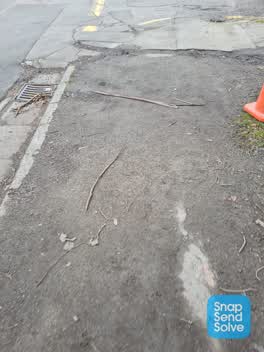 Pavement - Damaged —
 Again having to write and complain about state of footpath on Deans Ave from Hospital carpark to Lester Lane. It is absolutely dangerous to
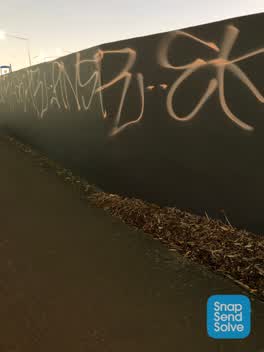 Graffiti —
 Along the footpath
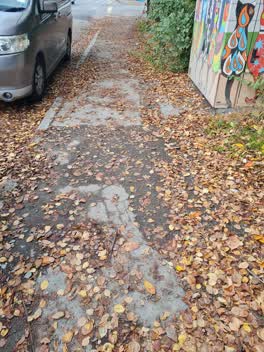 Roading/Streets —
 The footpath from the Hospital Carpark on Deans Ave towards Lester Lane is absolutely disgusting and extremely dangerous. With all the leav
Graffiti —
Roading/Streets —
Rubbish from car crash
Graffiti —
- Roading/Streets —
The pedestrian lights on Moorhouse Ave crossing Deans Ave don't work. No green or red signal and no beeping noise. Pedestrians only walk whe
Also reported on Deans Avenue
- 25 Deans Avenue — 37 reports
- 55 Deans Avenue — 36 reports
- 11 Deans Avenue — 29 reports
- 53 Deans Avenue — 20 reports
- 27 Deans Avenue — 6 reports
- 65 Deans Avenue — 5 reports
- 49 Deans Avenue — 5 reports
- 35 Deans Avenue — 4 reports
The street’s crash record
NZTA’s record names Deans Avenue in 38 crashes that hurt somebody since 2006 — 5 seriously hurt, nobody killed.
The green nearby
- Hagley Park South — 43 m to the edge · Sports ground · 71 ha
- Mountfort Park — 344 m to the edge · Botanic
- Christchurch Railway Station Reserve — 349 m to the edge · Botanic
- Walsall Reserve — 401 m to the edge
- Longley Reserve — 438 m to the edge
Parks within half a kilometre, measured to the boundary — the council’s open data.
On the doorstep
- mtf Finance — 70 m away · Company
- The Good Street Deli — 113 m away · Restaurants
- WSP — 128 m away · Business
- NZ Blood — 139 m away · Blood Donation
Businesses within four hundred metres, measured at the pin — OpenStreetMap and the council directories.
The bus nearby
- Lincoln Rd near Dickens St — 282 m away · route 7, route 120
- Lincoln Rd near Hazeldean Rd — 310 m away · route 7
The closest Metro stops, within four hundred and fifty metres.
The tracks through here
- Walk and bike track through Addington — the line crosses here · walk · bike
- Walk and bike track through Addington — 91 m to the line · walk · bike
- Walk and bike track through Addington — 100 m to the line · walk · bike
- Walk and bike track through Addington — 117 m to the line · walk · bike
- Walk and bike track through Addington — 287 m to the line · walk · bike
Tracks whose line passes within half a kilometre, measured to the line itself — the council’s open data.
The named ground
Named water within 500 m of this address, measured to the line or the edge; Named places within 1.5 km of this address — the open map’s record.
Renting nearby
new bonds in Addington ran about $502 a week — $48 below the city median of $550 — the suburb page keeps the rent record →.
The civic layer
This ground votes in Riccarton ward — the Halswell-Hornby-Riccarton community board. Ward lines don’t always follow suburb lines; this one is measured at the pin, not the suburb’s centre.
What stood on this ground → · On the map → · From the air — the Crown’s aerials back to 1936; search the address on RetroLens →
Questions, answered briefly
39 council reports on record since September 2017 — most often graffiti (9), pothole (5), roading/streets (3).
Addington, Christchurch — on Deans Avenue.
Nothing on the heritage register at this exact spot — the record around this ground →
Hagley Park South — 43 m to its edge, 71 ha.