178 Cashel Street, Christchurch Central City
28 reports on record since February 2021 · 21 with photographs. The street’s heaviest record is 210 Cashel Street — 53 reports on file. Indicative rating valuation and school zones, hazards, bin day and what stood here before.
What gets reported here
Photographed here 21 on record





Reported here
- General Request —
If you are pedestrian wanting to cross from the residential side to the other side where the Sweaty Betty retail store is, the lights are fa
 Overgrown Vegetation —
Basal shoots need removing from this tree please. They are almost encroaching onto the road. Directly opposite Sweaty Betty on MANCHESTER ST
 Traffic Signals —
The pedestrian button at this traffic light is broken, it is not popping back out.
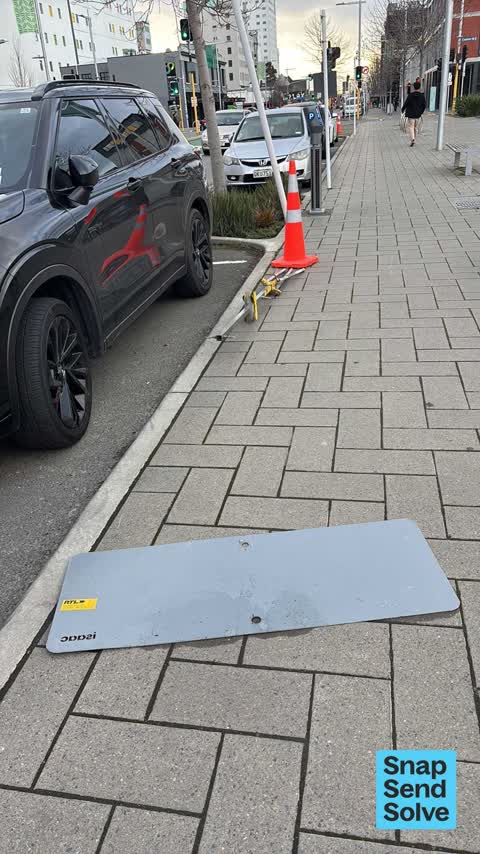
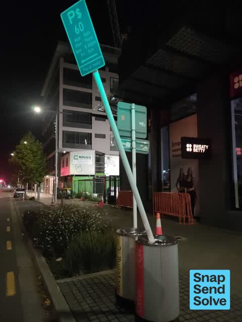
 Poles and Signage - General —
missing both poles/signs with the P60 restrictions as per photo
 Pavement - Damaged —
Underground service cover sinking. Major trip hazard.
 Graffiti on a traffic light pole or cabinet, or wa —
Black paint tag on traffic light pole on Lichfield Street corner of Manchester Street.
 Graffiti on a fence, building or structure —
Graffiti on wall
 General Request —
Black paint tags and sticky tags on steel lamp pole near 178 Cashel Street, on Manchester Street.
 Pavement - General —
Road signage needs removal or reerecting in Manchester Street near 178 Cashel Street.
 Graffiti on a fence, building or structure —
Black paint tags on tramlines pole (?) by the corner of 178 Cashel and Manchester Streets.
 Hazard — vehicle —
Parking meter is broken
 Poles and Signage - General —
Drunks came along and lifted out about 00.25 am. Your camera will see them
 Graffiti on a fence, building or structure —
Black paint tag on pedestrians traffic controller by 178 Cashel Street corner of Manchester Street.
 Graffiti on a cabinet, pole or railway asset —
 Pavement - Damaged —
Old pole needs to be taken down flush with the footpath at the corner of Cashel and Manchester Street. It’s an OHS issue for pedestrians saf
 Facility - General Request —
Chch earthquake CTV building memorial sign at Te Aio memorial garden badlyneeds cleaning / delaminated coating repaired. Speaks volumes of o
 Graffiti on a fence, building or structure —
Sea green paint tag on steel rubbish bin lid at the corner of Manchester and Cashel Street.
 Road Signage —
Not proper. Facing wrong way.
 Graffiti on a sign, mural or public art —
Black paint tag (plus a sticker) on bus sign at the corner of Cashel and Manchester Streets.
- Graffiti —
- Graffiti —
- Graffiti —
- Road Signage —
- Graffiti —
- Graffiti —
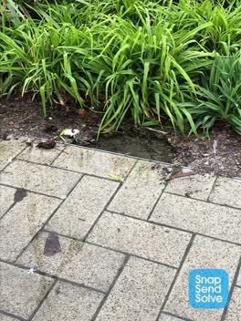 Pavement - General —
Water leak in pavement bed. Flooded in flower bed and pavement
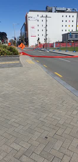 Roading/Streets —
Blowing over on road
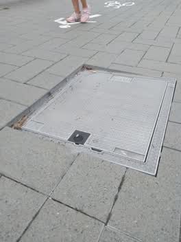 Roading/Streets —
partially submerge edge of man hole cover, trip hazard and hazard to bikes scooter etc
Also reported on Cashel Street
- 210 Cashel Street — 53 reports
- 219 Cashel Street — 46 reports
- 202 Cashel Street — 42 reports
- 208 Cashel Street — 41 reports
- 76 Cashel Street — 39 reports
- 7 Cashel Street — 37 reports
- 135 Cashel Street — 37 reports
- 75 Cashel Street — 34 reports
The street’s crash record
NZTA’s record names Cashel Street in 103 crashes that hurt somebody since 2006 — 1 person killed, 9 seriously hurt.
The green nearby
- Excelsior Hotel Reserve — 117 m to the edge · Botanic
- City Mall — 132 m to the edge
- High Street Triangles — 159 m to the edge
- The Stewart Plaza — 239 m to the edge
- Latimer Square — 250 m to the edge · Botanic · 2 ha
Parks within half a kilometre, measured to the boundary — the council’s open data.
The civic shelf nearby
- Triangle — 223 m away · Car park
- Re:start - Lichfield St — 335 m away · Car park
- Turanga Library — 416 m away · Library · Cathedral Square, Christchurch
- St Asaph — 438 m away · Car park
Libraries, halls and the rest within half a kilometre — the council’s open data.
On the doorstep
- Gelatiamo — 17 m away · Fast food
- Kai Run — 17 m away · Fast food
- Sweaty Betty — 27 m away · Clothing
- Pink Lady Rooftop — 38 m away · Bars & pubs
Businesses within four hundred metres, measured at the pin — OpenStreetMap and the council directories.
The bus nearby
- Bus Interchange (Platform D) — 184 m away · route 1, route 7, route 8, route 27, route 44, route 91, route 92, route 95
- Hereford St near Latimer Square — 190 m away · route 60
The closest Metro stops, within four hundred and fifty metres.
The tracks through here
- Walk and bike track through Christchurch Central City — 9 m to the line · walk · bike
- Walk and bike track through Christchurch Central City — 215 m to the line · walk · bike
- Walk and bike track through Christchurch Central City — 241 m to the line · walk · bike
- Walk and bike track through Christchurch Central City — 271 m to the line · walk · bike
- Walk and bike track through Christchurch Central City — 410 m to the line · walk · bike
Tracks whose line passes within half a kilometre, measured to the line itself — the council’s open data.
The named ground
Named places within 1.5 km of this address; the council’s own structure register — bridges, boardwalks and steps standing nearby — the open map’s record.
The remembered names nearby
- Te Kiheru Wai o Tahu / the Canoe Bailer of Tahu / 2015 — 104 m away ·
Te Kiheru Wai o Tahu / The Canoe Bailer of Tahu / 2015 / (MÄori text and English translat
· 2015 - The First Public Water Supply Well Was Drilled Near This — 210 m away ·
THE FIRST PUBLIC WATER SUPPLY WELL was drilled near this site on 10 February 1864 by the C
· 2009 - ‘corgis on High’ — Christchurch City Public Artwork — 215 m away ·
‘Corgis on High’ — Christchurch City public artwork, 6 December 2003
· 2009
Inscribed plaques within two hundred and fifty metres — the register’s pins, not surveyed spots. The whole roll is at /plaques.
Renting nearby
new bonds in Christchurch Central City ran about $508 a week — $42 below the city median of $550 — the suburb page keeps the rent record →.
What was here — 159 Manchester Street
41 m away · 159 Manchester Street · located to ±14 m · the place’s own record →
On the register. Nothing researched here yet.
What was here — Triangle Reserve and Setting
65 m away · 192F High Street · located to ±17 m · the place’s own record →
On the register. Nothing researched here yet.
What was here — Commercial Building and Setting
93 m away · 225 High Street · located to ±19 m · the place’s own record →
On the register. Nothing researched here yet.
What was here — Triangle Reserve and Setting
94 m away · 220F High Street · located to ±17 m · the place’s own record →
On the register. Nothing researched here yet.
What was here — Triangle Reserve and Setting
130 m away · 215F High Street · located to ±17 m · the place’s own record →
On the register. Nothing researched here yet.
The civic layer
This ground votes in Central ward — the Papanui-Innes-Central community board. Ward lines don’t always follow suburb lines; this one is measured at the pin, not the suburb’s centre.
What stood on this ground → · On the map → · From the air — the Crown’s aerials back to 1936; search the address on RetroLens →
Questions, answered briefly
28 council reports on record since February 2021 — most often graffiti (5), graffiti on a fence, building or structure (4), roading/streets (2).
Christchurch Central City, Christchurch — on Cashel Street.
The heritage register names 5 places at or beside it — 159 Manchester Street, Triangle Reserve and Setting.
Excelsior Hotel Reserve — 117 m to its edge.