195 Hereford Street, Christchurch Central City
41 reports on record since September 2020 · 33 with photographs. The street’s heaviest record is 53 Hereford Street, 125 reports on file. Indicative rating valuation and school zones, hazards, bin day and what stood here before.
What gets reported here
Photographed here 33 on record


Reported here
 Graffiti on a playground or in a park,
Tagging on lamps and green box
 Park - General Request,
VANDALISM: How long does our city need to be held ransom to youths causing wilful damage and destruction to public property, enabled by Lime
 Graffiti on a playground or in a park,
Someone has put sheep/poo pellets all over this public seating area. Usually a lot of people use this space including food distribution to r
 Graffiti on a playground or in a park,
 Damaged Street Light,
Tagging on lamppost behind club
 Graffiti on a road, footpath or bridge,
Tagging on concrete road edges plus sign pole lying on ground
 Graffiti on a road, footpath or bridge,
More tagging on road edge Hereford Street by Huanui Lane
 Graffiti on a fence, building or structure,
On council bollard near Semisi Potauaine art work
 Graffiti on a fence, building or structure,
On a container inside Christchurch or Canterbury Club.
 Poles and Signage - General,
Graffiti
 Graffiti on a fence, building or structure,
graffiti on ccc cabinet
 Graffiti on a playground or in a park,
 Graffiti on a playground or in a park,
TAGGING on some kind of phone or power boxes. Throughout Rauora Park.
 Graffiti on a road, footpath or bridge,
TAGGING on median strip.
 Graffiti on a playground or in a park,
TAGGING on multiple light poles throughout Rauora Park. There is also tagging along the gutters by the pathway. Please remove chemically or
 Graffiti on a playground or in a park,
TAGGING on raised concrete border of Rauora Park. Please remove chemically or with water blasting. Grey paint ruins the aesthetic of the con
 Hazard, vehicle,
Repeat illegal parking next to the construction site on the lane way . Every day there is illegally parked vehicle on the road and also park
 Damaged Street Sign,
Damaged recycle bins
 Graffiti on a fence, building or structure,
 Graffiti on a fence, building or structure,
Tagging along multiple structures in and around Rauora Park.
 Graffiti somewhere else,
 Street Light Outage,
North West corner of Christchurch club on Roara Park, between Hereford and Worcester.
 Graffiti,
Oppsite 1/197 Hereford st apartments
 Pavement - General,
Something has been split on the concrete and it looks terrible I tried to hose it off and didn’t work can somebody please come and sort asap
- Water Leak,
- Graffiti,
- Graffiti,
- Pavement - Damaged,
- Graffiti,
- Poles and Signage - General,
- Hazard, vehicle,
- Hazard, vehicle,
 Graffiti,
 Graffiti,
 General Request,
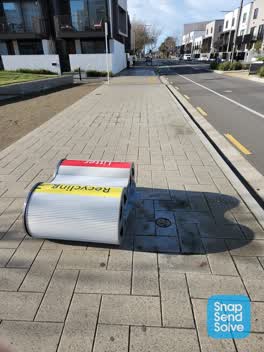 Rubbish/Recycling,
Bin knocked over
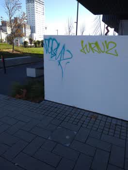 Graffiti,
Please fix this it's on the south wall of 197 Hereford Street
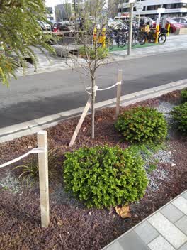 Roading/Streets,
Many of the kowhai trees along Oxford terrace adjacent to the earthquake memorial have broken support stakes. It would seem as if most of th
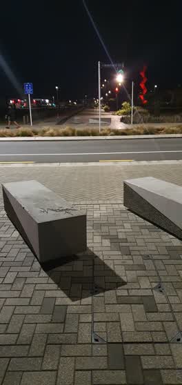 Graffiti,
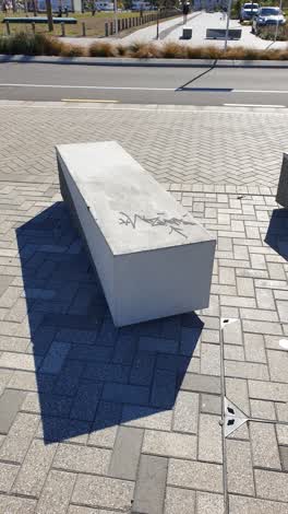 Graffiti,
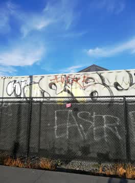 Graffiti,
On the crate and also along the black fenceline
Also reported on Hereford Street
- 53 Hereford Street, 125 reports
- 71 Hereford Street, 91 reports
- 48 Hereford Street, 76 reports
- 197 Hereford Street, 62 reports
- 141 Hereford Street, 62 reports
- 262 Hereford Street, 59 reports
- 214 Hereford Street, 53 reports
- 147 Hereford Street, 46 reports
From the air, then
Sourced from Canterbury Maps and partners. LINZ, CC BY 3.0 NZ. Each frame is cut from Environment Canterbury’s historic imagery MapServer for that decade, only where the Footprints layer names a CC BY survey (NZAM-covered spots stay out). RetroLens holds more Crown aerials →
The street’s crash record
NZTA’s record names Hereford Street in 154 crashes that hurt somebody since 2006, 1 person killed, 25 seriously hurt.
The green nearby
- Latimer Square, 118 m to the edge · Botanic · 2 ha
- Cathedral Square, 257 m to the edge · Botanic
- City Mall, 260 m to the edge
- High Street Triangles, 283 m to the edge
- The Stewart Plaza, 311 m to the edge
Parks within half a kilometre, measured to the boundary, the council’s open data.
The civic shelf nearby
- Triangle, 321 m away · Car park
- Turanga Library, 330 m away · Library · Cathedral Square, Christchurch
Libraries, halls and the rest within half a kilometre, the council’s open data.
On the doorstep
- Christchurch Club, 71 m away · Clubs
- Mexico, 110 m away · Restaurants
- Mexico Restaurant, 111 m away · Restaurants
- Paddy McNaughton's, 114 m away · Bars & pubs
Businesses within four hundred metres, measured at the pin: OpenStreetMap and the council directories.
The bus nearby
- Hereford St near Latimer Square, 73 m away · route 60
- Hereford St near Latimer Square, 77 m away · route 60
The closest Metro stops, within four hundred and fifty metres.
The tracks through here
- Walk and bike track through Christchurch Central City, 74 m to the line · walk · bike
- Walk and bike track through Christchurch Central City, 90 m to the line · walk · bike
- Walk and bike track through Christchurch Central City, 316 m to the line · walk · bike
- Walk and bike track through Christchurch Central City, 351 m to the line · walk · bike
- Walk and bike track through Christchurch Central City, 388 m to the line · walk · bike
Tracks whose line passes within half a kilometre, measured to the line itself, the council’s open data.
The named ground
Named water within 500 m of this address, measured to the line or the edge; Named places within 1.5 km of this address; the council’s own structure register, bridges, boardwalks and steps standing nearby, the open map’s record.
The remembered names nearby
- In Memory of / Jaime Robert McDowell Gilbert, 188 m away ·
IN MEMORY OF / JAIME ROBERT MCDOWELL GILBERT / WHO LOST HIS LIFE / AT THIS LOCATION IN THE
· 2018
Inscribed plaques within two hundred and fifty metres, the register’s pins, not surveyed spots. The whole roll is at /plaques.
Renting nearby
new bonds in Christchurch Central City ran about $508 a week, $42 below the city median of $550, the suburb page keeps the rent record →.
What was here, Christchurch Club and Setting
79 m away · 154 Worcester Street · located to ±16 m · the place’s own record →
On the register. Nothing researched here yet.
What was here, Shands Emporium: Former Commercial Building
109 m away · 217 Manchester Street · located to ±6 m · the place’s own record →
On the register. Nothing researched here yet.
What was here, Former Trinity Congregational Church and Setting
119 m away · 124 Worcester Street · located to ±14 m · the place’s own record →
On the register. Nothing researched here yet.
What was here, 167 Hereford Street
133 m away · 167 Hereford Street · located to ±11 m · the place’s own record →
On the register. Nothing researched here yet.
What was here, Commercial Building and Setting, Former State Insurance
134 m away · 58/28 Cathedral Square · located to ±28 m · the place’s own record →
On the register. Nothing researched here yet.
The civic layer
This ground votes in Central ward, the Papanui-Innes-Central community board. Ward lines don’t always follow suburb lines; this one is measured at the pin, not the suburb’s centre.
What stood on this ground → · On the map → · From the air, the Crown’s aerials back to 1936; search the address on RetroLens →
Questions, answered briefly
41 council reports on record since September 2020, most often graffiti (10), graffiti on a playground or in a park (7), graffiti on a fence, building or structure (5).
Christchurch Central City, Christchurch, on Hereford Street.
The heritage register names 5 places at or beside it, Christchurch Club and Setting, Shands Emporium: Former Commercial Building.
Latimer Square, 118 m to its edge, 2 ha.