204 Manchester Street, Christchurch Central City
45 reports on record since May 2022 · 32 with photographs. The street’s heaviest record is 297-299 Manchester Street — 102 reports on file. Indicative rating valuation and school zones, hazards, bin day and what stood here before.
What gets reported here
Photographed here 32 on record


Reported here
 Graffiti on a fence, building or structure —
graffiti on bin
 Graffiti on a fence, building or structure —
graffiti on black fence
 General Request —
thank you!
 Graffiti on a fence, building or structure —
- Street Light Outage —
The entire block, Manchester between Worcester and Gloucester had no street lighting yesterday or today
 Roads - General —
Please can you take down
 Graffiti on a road, footpath or bridge —
 Graffiti somewhere else —
 Graffiti somewhere else —
 Graffiti on a fence, building or structure —
Cream paint tag on roller park path by 204 Manchester Street.
 Graffiti on a cabinet, pole or railway asset —
Silver and white paint tags on anonymous locked asset by 204 Manchester Street.
 Graffiti somewhere else —
Traffic signals control box at Manchester St Gloucester St
 Graffiti somewhere else —
Near one central northside
- Graffiti on a road, footpath or bridge —
 Graffiti on a cabinet, pole or railway asset —
 Graffiti somewhere else —
Middle island
 Graffiti somewhere else —
 Graffiti on a playground or in a park —
Parks team couldn't remove
 Graffiti somewhere else —
 Graffiti on a fence, building or structure —
Black paint tags on 2 bins at the corner of Manchester and Gloucester Streets.
 Graffiti on a cabinet, pole or railway asset —
 Graffiti somewhere else —
On green utility box by cycle stands near bus stop. By vacant lot
 Graffiti somewhere else —
 Graffiti on a fence, building or structure —
Pink paint tag on anonymous dark green asset by 204 Manchester Street.
 Graffiti somewhere else —
 Graffiti —
 Graffiti —
Tags on the posts of both traffic lights on the corner of Manchester St and Gloucester St ( the side of the empty/old car park site)
 Pavement - General —
Sign lying in carpak
 Graffiti —
Graffiti located on bin
- Graffiti —
- General Request —
- Graffiti —
- Graffiti —
- Graffiti —
- Graffiti —
- Pavement - General —
- Graffiti —
- Graffiti —
- Graffiti —
- Graffiti —
 Graffiti —
Central city team can't remove
 Graffiti —
Central city team can't remove
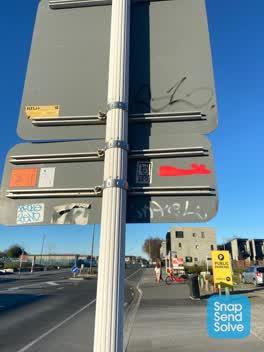 Graffiti —
Black and white paint tags on both sides of the sign on the corner of Gloucester and Manchester Streets.
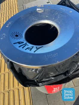 Graffiti —
PKAY black paint tag on steel rubbish bin lid on the corner of Manchester and Gloucester Streets.
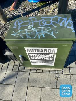 Graffiti —
Blue and white paint tags on anonymous locked asset just north of bus shelter on Manchester Street near Gloucester Street, by a car park fac
Also reported on Manchester Street
- 297-299 Manchester Street — 102 reports
- 293 Manchester Street — 72 reports
- 214 Manchester Street — 72 reports
- 153 Manchester Street — 52 reports
- 218 Manchester Street — 48 reports
- 76 Manchester Street — 45 reports
- 192 Manchester Street — 40 reports
- 39 Manchester Street — 39 reports
The street’s crash record
NZTA’s record names Manchester Street in 235 crashes that hurt somebody since 2006 — 1 person killed, 38 seriously hurt.
The green nearby
- Latimer Square — 186 m to the edge · Botanic · 2 ha
- Cathedral Square — 202 m to the edge · Botanic
- Edmonds Band Rotunda — 221 m to the edge · Botanic
- Poplars Reserve — 302 m to the edge · Botanic
- Victoria Square — 305 m to the edge · Botanic · 2 ha
Parks within half a kilometre, measured to the boundary — the council’s open data.
The civic shelf nearby
- Turanga Library — 214 m away · Library · Cathedral Square, Christchurch
- Triangle — 383 m away · Car park
Libraries, halls and the rest within half a kilometre — the council’s open data.
On the doorstep
- Fletcher Living — 25 m away · Business
- Crew Technology Recruitment — 37 m away · Recruitment
- Purple Dragon Noodles Food Cart — 48 m away · Fast food
- Sampan House — 50 m away · Restaurants
Businesses within four hundred metres, measured at the pin — OpenStreetMap and the council directories.
The bus nearby
- Manchester St Super Stop — 91 m away · route 1, route 5, route 7, route 8, route 27, route 29, route 44, route 86, route 91, route 92, route 95
- Gloucester St near Latimer Square — 124 m away · route 5, route 7
The closest Metro stops, within four hundred and fifty metres.
The tracks through here
- Walk and bike track through Christchurch Central City — 15 m to the line · walk · bike
- Walk and bike track through Christchurch Central City — 110 m to the line · walk · bike
- Walk and bike track through Christchurch Central City — 132 m to the line · walk · bike
- Walk and bike track through Christchurch Central City — 200 m to the line · walk · bike
- Walk and bike track through Christchurch Central City — 263 m to the line · walk · bike
Tracks whose line passes within half a kilometre, measured to the line itself — the council’s open data.
The named ground
Named water within 500 m of this address, measured to the line or the edge; Named places within 1.5 km of this address; the council’s own structure register — bridges, boardwalks and steps standing nearby — the open map’s record.
The remembered names nearby
- In Memory of / Jaime Robert McDowell Gilbert — 11 m away ·
IN MEMORY OF / JAIME ROBERT MCDOWELL GILBERT / WHO LOST HIS LIFE / AT THIS LOCATION IN THE
· 2018 - Margaret Mahy Family Playground — 157 m away ·
MARGARET MAHY FAMILY PLAYGROUND / Officially opened on 22 December 2015 by / Elsie Mahy /
· 2017 - Godley Statue Reserve plaque — 220 m away · 1899
Inscribed plaques within two hundred and fifty metres — the register’s pins, not surveyed spots. The whole roll is at /plaques.
Renting nearby
new bonds in Christchurch Central City ran about $508 a week — $42 below the city median of $550 — the suburb page keeps the rent record →.
What was here — New Regent Street Shops and Setting
112 m away · 17 New Regent Street · located to ±48 m · the place’s own record →
On the register. Nothing researched here yet.
What was here — Former MED Converter Station and Substation
129 m away · 102/210 Armagh Street · located to ±30 m · the place’s own record →
On the register. Nothing researched here yet.
What was here — Commercial Building Façade and Setting, Former A W Smith and Son's Central Garage/Mayfair-Cinerama Theatre
138 m away · 115A Worcester Street · located to ±12 m · the place’s own record →
On the register. Nothing researched here yet.
What was here — Theatre Royal Façade, Dome, Staircase and Setting
141 m away · 145 Gloucester Street · located to ±24 m · the place’s own record →
On the register. Nothing researched here yet.
What was here — Former Trinity Congregational Church and Setting
142 m away · 124 Worcester Street · located to ±14 m · the place’s own record →
On the register. Nothing researched here yet.
The civic layer
This ground votes in Central ward — the Papanui-Innes-Central community board. Ward lines don’t always follow suburb lines; this one is measured at the pin, not the suburb’s centre.
What stood on this ground → · On the map → · From the air — the Crown’s aerials back to 1936; search the address on RetroLens →
Questions, answered briefly
45 council reports on record since May 2022 — most often graffiti (17), graffiti somewhere else (10), graffiti on a fence, building or structure (6).
Christchurch Central City, Christchurch — on Manchester Street.
The heritage register names 5 places at or beside it — New Regent Street Shops and Setting, Former MED Converter Station and Substation.
Latimer Square — 186 m to its edge, 2 ha.