76 Manchester Street, Christchurch Central City
45 reports on record since November 2019 · 29 with photographs. The street’s heaviest record is 297-299 Manchester Street — 102 reports on file. Indicative rating valuation and school zones, hazards, bin day and what stood here before.
What gets reported here
Photographed here 29 on record


Reported here
 Dumped Rubbish —
Street rubbish
 Graffiti on a fence, building or structure —
Graffiti on a wall
 Graffiti on a traffic light pole or cabinet, or wa —
 Dumped Rubbish —
Very heavy sign board dumped on the verge by the corner of St Asaph and Manchester Street needs repair or removal ASAP.
 Rubbish and Bins - General —
Metal sign and rubbish bin that doesn't belong here
 Accessibility —
Flag sign hanging less than 2m above the continuous accessible path of travel. If contained upright from the base it would be within non fen
 Graffiti on a fence, building or structure —
Graffiti on side of the building.
 Graffiti somewhere else —
 Graffiti on a fence, building or structure —
Graffiti on side of the building.
 Graffiti on a fence, building or structure —
Graffiti on the side of the building.
 Graffiti somewhere else —
 Graffiti on a fence, building or structure —
2 gas assets badly tagged on Manchester Street a tad south of St Asaph Street.
 Graffiti on a fence, building or structure —
Graffiti on building.
 Graffiti somewhere else —
At meter box
 Graffiti —
 Graffiti —
 Graffiti —
- Graffiti —
- Graffiti —
- Poles and Signage - General —
- Graffiti —
- Graffiti —
- Graffiti —
- Graffiti —
- Graffiti —
- Graffiti —
- Graffiti —
- Graffiti —
- Graffiti —
- Graffiti —
- Graffiti —
- Graffiti —
 Graffiti —
Rockgas, outside Moment cafe.
 Graffiti —
Black paint tags on white wooden railing on the corner of St Asaph and Manchester Streets facing the footpath.
 Pavement - General —
Broken Glass in the cycleway
 Pavement - General —
Broken Glass in the cycleway
 Pavement - General —
Broken Glass in the cycleway
- Roading/Streets —
Lights at St Asaph Manchester only allowing 2-3 north/southbound vehicles through intersection at night. Right turning traffic onto St Asaph
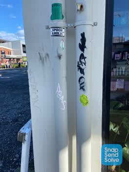 Graffiti —
Black and pink paint tags (plus sticky tags) on wall of True Grit facing the footpath on Manchester Street a tad north of Welles Street.
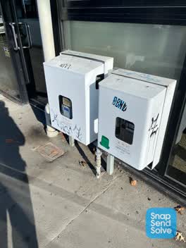 Graffiti —
Black and blue paint tags on 2 Rockgas assets by 87 Manchester Street.
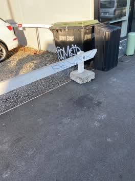 Graffiti —
RELAX blue paint tag on white wooden railing facing the footpath on Manchester Street close to St Asaph Street.
 Graffiti —
Manchester Street, Two plastic recycling bins, at Reserved EnableMe carparks area. Christchurch city areas.
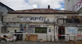 Graffiti —
Manchester Street and St Asaph Street at the corner of Reserved parking places. Christchurch city areas.
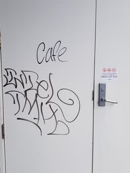 Graffiti —
245 St Asaph Street, Christchurch city areas. in front of Fairview building.
Roading/Streets —
light on bar stick out on an angle, with east corner of Manchester and St Asaph Sts
Also reported on Manchester Street
- 297-299 Manchester Street — 102 reports
- 293 Manchester Street — 72 reports
- 214 Manchester Street — 72 reports
- 153 Manchester Street — 52 reports
- 218 Manchester Street — 48 reports
- 204 Manchester Street — 45 reports
- 192 Manchester Street — 40 reports
- 39 Manchester Street — 39 reports
The street’s crash record
NZTA’s record names Manchester Street in 235 crashes that hurt somebody since 2006 — 1 person killed, 38 seriously hurt.
The green nearby
- Excelsior Hotel Reserve — 210 m to the edge · Botanic
- Wilson Park — 242 m to the edge
- City Mall — 394 m to the edge
- High Street Triangles — 420 m to the edge
- Gasson Reserve — 448 m to the edge
Parks within half a kilometre, measured to the boundary — the council’s open data.
The civic shelf nearby
- St Asaph — 314 m away · Car park
- Re:start - Lichfield St — 348 m away · Car park
- Triangle — 469 m away · Car park
Libraries, halls and the rest within half a kilometre — the council’s open data.
On the doorstep
- Concentrate — 9 m away · Business
- Turbo Staff — 21 m away · Recruitment
- Moment — 24 m away · Cafés
- Mish Mash — 28 m away · Bars & pubs
Businesses within four hundred metres, measured at the pin — OpenStreetMap and the council directories.
The bus nearby
- Manchester St near Welles St — 113 m away · route 27
- Manchester St near Allen St — 181 m away · route 27, route 84, route 85, route 95
The closest Metro stops, within four hundred and fifty metres.
The tracks through here
- Walk and bike track through Christchurch Central City — 11 m to the line · walk · bike
- Walk and bike track through Christchurch Central City — 136 m to the line · walk · bike
- Walk and bike track through Christchurch Central City — 175 m to the line · walk · bike
- Walk and bike track through Christchurch Central City — 234 m to the line · walk · bike
- Walk and bike track through Christchurch Central City — 379 m to the line · walk · bike
Tracks whose line passes within half a kilometre, measured to the line itself — the council’s open data.
The named ground
Named places within 1.5 km of this address; the council’s own structure register — bridges, boardwalks and steps standing nearby — the open map’s record.
The remembered names nearby
- ‘corgis on High’ — Christchurch City Public Artwork — 171 m away ·
‘Corgis on High’ — Christchurch City public artwork, 6 December 2003
· 2009 - The First Public Water Supply Well Was Drilled Near This — 171 m away ·
THE FIRST PUBLIC WATER SUPPLY WELL was drilled near this site on 10 February 1864 by the C
· 2009
Inscribed plaques within two hundred and fifty metres — the register’s pins, not surveyed spots. The whole roll is at /plaques.
Renting nearby
new bonds in Christchurch Central City ran about $508 a week — $42 below the city median of $550 — the suburb page keeps the rent record →.
What was here — Former R. Buchanan & Sons' City Foundry and Setting
111 m away · 2/210 St Asaph Street · located to ±14 m · the place’s own record →
On the register. Nothing researched here yet.
What was here — Former P & D Duncan Ltd Building and Setting
134 m away · 7/204 St Asaph Street · located to ±18 m · the place’s own record →
On the register. Nothing researched here yet.
What was here — Commercial Building and Setting, Lawrie and Wilson Auctioneers
134 m away · 210 Tuam Street · located to ±14 m · the place’s own record →
On the register. Nothing researched here yet.
What was here — Former Tuam Street Hall and Setting
135 m away · 214 Tuam Street · located to ±12 m · the place’s own record →
On the register. Nothing researched here yet.
What was here — Commercial Building Façade and Setting, Former A J Whites
159 m away · 181 High Street · located to ±20 m · the place’s own record →
On the register. Nothing researched here yet.
The civic layer
This ground votes in Central ward — the Papanui-Innes-Central community board. Ward lines don’t always follow suburb lines; this one is measured at the pin, not the suburb’s centre.
What stood on this ground → · On the map → · From the air — the Crown’s aerials back to 1936; search the address on RetroLens →
Questions, answered briefly
45 council reports on record since November 2019 — most often graffiti (25), graffiti on a fence, building or structure (6), pavement - general (3).
Christchurch Central City, Christchurch — on Manchester Street.
The heritage register names 5 places at or beside it — Former R. Buchanan & Sons' City Foundry and Setting, Former P & D Duncan Ltd Building and Setting.
Excelsior Hotel Reserve — 210 m to its edge.