286 Oxford Terrace, Christchurch Central City
69 reports on record since May 2018 · 43 with photographs. The street’s heaviest record is 159 Oxford Terrace — 180 reports on file. Indicative rating valuation and school zones, hazards, bin day and what stood here before.
What gets reported here
- Graffiti — 28
- Graffiti on a fence, building or structure — 9
- Graffiti on a sign, mural or public art — 5
- Graffiti somewhere else — 3
- Graffiti on a road, footpath or bridge — 3
- General Request — 3
Photographed here 43 on record


Reported here
 Graffiti on a fence, building or structure —
  Graffiti on a playground or in a park —
  Graffiti on a fence, building or structure —
 Parks team couldn’t remove
 Graffiti on a sign, mural or public art —
 grafitti
 Traffic Signals —
 Broken pedestrian button
 Graffiti on a road, footpath or bridge —
 Parks team couldn’t remove
 Poles and Signage - General —
 Yet another stolen plaque
 General Request —
 Black paint tag on Orion metal lamp pole by the corner of 286 Oxford Terrace and Madras Street.
 Damaged Street Sign —
 Blown off in the wind?
 Graffiti on a sign, mural or public art —
 As per photo - graffiti on give way sign
 Graffiti on a fence, building or structure —
 Graffiti on light lamp post
 Graffiti on a fence, building or structure —
  Graffiti on a sign, mural or public art —
 Black and blue paint tags on reverse side of road sign on Madras Street at the corner of 286 Oxford Terrace.
 Graffiti somewhere else —
 Graffiti steps beside bridge madras oxford corner
 Graffiti somewhere else —
  Graffiti on a road, footpath or bridge —
  Graffiti on a fence, building or structure —
  Graffiti on a fence, building or structure —
 White paint tag on the top rail of the River Avon bridge on Madras Street western side.
 General Request —
 An escxoter is in the river please remove it
 Graffiti on a sign, mural or public art —
 Black graffiti on back of give way sign. Entrance to Firefighters Reserve. Corner of Oxford Tce and Madras St.
 Graffiti somewhere else —
  Pavement - Damaged —
 There’s a huge hole in the footpath on the bridge which has been there for months and not repaired…,
 Graffiti on a road, footpath or bridge —
 Black graffiti on blue sign. Corner of Madras St and Oxford Tce, basically on the bridge.
 Graffiti on a fence, building or structure —
 On the dedication at Edmonds clock tower
 Trees - General —
 can you pick up this branch
 Graffiti on a fence, building or structure —
 Green and gray paint tag on Avon River concrete post by the corner of Oxford Terrace and Madras Street.
 Graffiti on a sign, mural or public art —
 Black paint tag (plus sticky tags) on reverse side of Give Way sign at the corner of Madras Street and Oxford Terrace.
 Graffiti on a fence, building or structure —
  Graffiti —
  Graffiti —
 At the bottom of stairs on the side of the bridge at fire fighters reserve, parks team unable to remove
 Damaged Street Sign —
 Someone has tried to remove the brass plaque on the madras street bridge that goes over the Avon river. I am concerned they may come back t
 Graffiti —
  Graffiti —
 - Graffiti —
- Graffiti —
- Graffiti —
- General Request —
- Pavement - Damaged —
- Graffiti —
- Graffiti —
- Graffiti —
- Graffiti —
- Graffiti —
- Graffiti —
- Graffiti —
- Graffiti —
- Graffiti —
- Graffiti —
- Graffiti —
- Damaged Street Sign —
- Street Gutters / Storm Water —
- Street Gutters / Storm Water —
- Graffiti —
- Graffiti —
- General - Abandoned Trolley —
- Graffiti —
- Graffiti —
- Damaged Street Light —
- Damaged Street Light —
 Overgrown Vegetation —
 Design plan shows how it should be. Call me at CCC design office 9416697 Nigel Weston
 Graffiti —
  Street Light Outage —
 1 of the 4 round lights is dead/flickering. Time is also off, but not such a pressing issue
 Damaged Street Light —
 Constantly flickering light
 Graffiti —
  Graffiti —
 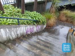 Graffiti —
 On concrete of memorial. CCC Parks staff can't remove. Thanks
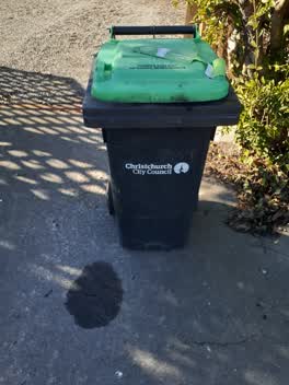 Rubbish/Recycling —
 This bin is of no fixed abode and has turned up outside a property that I property manage. The address off the property is 36 Gilby Street.
Graffiti —
Graffiti —
SE corner of bridge in firefighters reserve
Also reported on Oxford Terrace
- 159 Oxford Terrace — 180 reports
- 153 Oxford Terrace — 174 reports
- 95 Oxford Terrace — 126 reports
- 211 Oxford Terrace — 125 reports
- 182 Oxford Terrace — 122 reports
- 184 Oxford Terrace — 109 reports
- 294 Oxford Terrace — 92 reports
- 152 Oxford Terrace — 87 reports
The street’s crash record
NZTA’s record names Oxford Terrace in 56 crashes that hurt somebody since 2006 — 1 person killed, 11 seriously hurt.
The green nearby
- Poplars Reserve — 13 m to the edge · Botanic
- Fire Fighters Reserve — 18 m to the edge
- Cambridge Reserve — 38 m to the edge
- Edmonds Band Rotunda — 263 m to the edge · Botanic
- Latimer Square — 314 m to the edge · Botanic · 2 ha
Parks within half a kilometre, measured to the boundary — the council’s open data.
On the doorstep
- Pillars Cafe — 18 m away · Cafés
- Christchurch Sea Kayaking — 128 m away · Attractions
- Table at Monks — 161 m away · Restaurants
- Kea Coffee Cafe Cart — 174 m away · Cafés
Businesses within four hundred metres, measured at the pin — OpenStreetMap and the council directories.
The bus nearby
- Manchester St near Kilmore St — 256 m away · route 44, route 91, route 92
- Manchester St near Kilmore St — 259 m away · route 1, route 27, route 29, route 44, route 91, route 92, route 95
The closest Metro stops, within four hundred and fifty metres.
The tracks through here
- Walk and bike track through Christchurch Central City — 1 m to the line · walk · bike
- Walk and bike track through Christchurch Central City — 2 m to the line · walk · bike
- Walk and bike track through Christchurch Central City — 63 m to the line · walk · bike
- Walk and bike track through Christchurch Central City — 88 m to the line · walk · bike
- Walk and bike track through Christchurch Central City — 132 m to the line · walk · bike
Tracks whose line passes within half a kilometre, measured to the line itself — the council’s open data.
The named ground
Named water within 500 m of this address, measured to the line or the edge; Named places within 1.5 km of this address; the council’s own structure register — bridges, boardwalks and steps standing nearby — the open map’s record.
The remembered names nearby
- City Care — 29 m away ·
city care (logo paving stone)
· 2009 - John Rhind Funeral Directors Since 1881 — 40 m away ·
JOHN RHIND Funeral Directors Since 1881 ... a continuing family tradition
· 2009 - This Clock Tower, Telephone Cabinet and All Standard Lights — 42 m away ·
THIS CLOCK TOWER, TELEPHONE CABINET AND ALL STANDARD LIGHTS IN POPLAR CRESCENT WERE PRESEN
· 2009
Inscribed plaques within two hundred and fifty metres — the register’s pins, not surveyed spots. The whole roll is at /plaques.
Renting nearby
new bonds in Christchurch Central City ran about $508 a week — $42 below the city median of $550 — the suburb page keeps the rent record →.
What was here — Edmonds Clock Tower, Telephone Cabinet and Setting
51 m away · 295F Madras Street · located to ±15 m · the place’s own record →
On the register. Nothing researched here yet.
What was here — Dwellings and Setting
92 m away · 86 Chester Street East · located to ±15 m · the place’s own record →
On the register. Nothing researched here yet.
What was here — Dwellings and Setting
108 m away · 100 Chester Street East · located to ±13 m · the place’s own record →
On the register. Nothing researched here yet.
What was here — Poplars, Lamp Standards and Setting
on this spot · located to ±139 m · the place’s own record →
On the register. Nothing researched here yet.
What was here — Former Vicarage of the Church of St Luke the Evangelist and Setting
191 m away · 185 Kilmore Street · located to ±12 m · the place’s own record →
On the register. Nothing researched here yet.
The civic layer
This ground votes in Central ward — the Papanui-Innes-Central community board. Ward lines don’t always follow suburb lines; this one is measured at the pin, not the suburb’s centre.
What stood on this ground → · On the map → · From the air — the Crown’s aerials back to 1936; search the address on RetroLens →
Questions, answered briefly
69 council reports on record since May 2018 — most often graffiti (28), graffiti on a fence, building or structure (9), graffiti on a sign, mural or public art (5).
Christchurch Central City, Christchurch — on Oxford Terrace.
The heritage register names 5 places at or beside it — Edmonds Clock Tower, Telephone Cabinet and Setting, Dwellings and Setting.
Poplars Reserve — 13 m to its edge.