32 Oxford Terrace, Christchurch Central City
29 reports on record since November 2019 · 20 with photographs. The street’s heaviest record is 159 Oxford Terrace — 180 reports on file. Indicative rating valuation and school zones, hazards, bin day and what stood here before.
What gets reported here
Photographed here 20 on record


Reported here
 Overgrown Vegetation —
 trees overgrown over shared use path. This is probably the busiest shared use path in town. at least a 1/4 of it is blocked by these trees (
 Overgrown Vegetation —
 trees overhanging the shared pathway blocking a third of the width.
 Overgrown Vegetation —
 overgrown trees partially obstructing footpath causing congestion and increased risk of trip/fall incidents or pedestrian v scooter/bike inc
 Pavement - General —
 the new sign is pointing the wrong way
 Graffiti on a fence, building or structure —
 - Pavement - General —
I cycle to work at 32 Oxford Terrace. The entrance to the bike shed is on Tuam Street, at the back of the building. The contractors building
 Graffiti on a fence, building or structure —
 Black and white paint tags on glass of FFP fire cabinet in Tuam Street opposite Miles VW, facing the footpath.
 Graffiti on a cabinet, pole or railway asset —
 Various graffiti on metal communications box. Opposite Miles Continental (VW).
 Graffiti on a fence, building or structure —
  Graffiti on a fence, building or structure —
 Multiple black and white paint tags on Contact gas asset on Tuam Street opposite VW.
 Graffiti on a fence, building or structure —
 Black paint tag on end of wooden fence by a large construction site facing the footpath on Tuam Street opposite VW car yard.
 Vandalism - General —
 graffiti on the sign
 Graffiti somewhere else —
 Gas box?
 Graffiti —
 Tuam st near eats on Oxford
 Rubbish and Bins - General —
 Yet another Lime Scooter trashed in River Avon , needs collection ,
- Vandalism - General —
- Overgrown Vegetation —
- Overgrown Vegetation —
- Fallen Tree —
- Hazard — vehicle —
- Park - General Request —
- Fallen Tree —
- Graffiti —
 Pit and Equipment - General —
 I get they may need to temporarily block the footpath but really? Who put up a fence that blocked the footpath and left a bin blocking the o
 Overgrown Vegetation —
 There's about 4 new Kowhai trees in the rain gardens that have been bent over recently. They need re-staking before they get comfortable in
 Fallen Tree —
 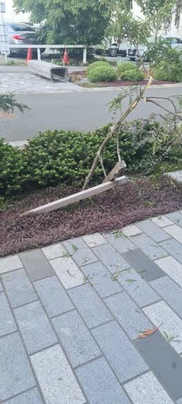 Roading/Streets —
 many trees snapped in half between Montreal and the hospital on the walk way other trees have branches broken
 Graffiti —
 Roading/Streets —
I believe this is no parking area.
Also reported on Oxford Terrace
- 159 Oxford Terrace — 180 reports
- 153 Oxford Terrace — 174 reports
- 95 Oxford Terrace — 126 reports
- 211 Oxford Terrace — 125 reports
- 182 Oxford Terrace — 122 reports
- 184 Oxford Terrace — 109 reports
- 294 Oxford Terrace — 92 reports
- 152 Oxford Terrace — 87 reports
The street’s crash record
NZTA’s record names Oxford Terrace in 56 crashes that hurt somebody since 2006 — 1 person killed, 11 seriously hurt.
The green nearby
- Botanic Gardens — 237 m to the edge · Botanic · 21 ha
- Tiffany Reserve — 245 m to the edge
- Friendship Corner — 325 m to the edge · Botanic
- Bridge Of Remembrance — 341 m to the edge · Botanic
- Nurses Memorial Chapel — 408 m to the edge · Botanic
Parks within half a kilometre, measured to the boundary — the council’s open data.
The civic shelf nearby
- Scales — 200 m away · Car park
- Civic Offices — 389 m away · Council office
- Christchurch Hospital Grounds — 442 m away · Car park
- Rolleston Avenue — 497 m away · Car park
Libraries, halls and the rest within half a kilometre — the council’s open data.
On the doorstep
- Black and White coffee Cartel — 6 m away · Cafés
- MetroMart — 12 m away · Dairies & convenience
- Taste of Malaysia Kitchen - Eats on Oxford — 18 m away · Fast food
- Canterbury District Health Board — 21 m away · Government
Businesses within four hundred metres, measured at the pin — OpenStreetMap and the council directories.
The bus nearby
- Christchurch Hospital Main Stop EB — 167 m away · route 3, route 5, route 7, route 60, route 80, route 81, route 84, route 85, route 86, route 91, route 92
- St Asaph St near Montreal St — 188 m away · route 3, route 5, route 7, route 60, route 80, route 81, route 84, route 85, route 86
The closest Metro stops, within four hundred and fifty metres.
The tracks through here
- Walk and bike track through Christchurch Central City — 49 m to the line · walk · bike
- Walk and bike track through Christchurch Central City — 150 m to the line · walk · bike
- Walk and bike track through Christchurch Central City — 157 m to the line · walk · bike
- Walk and bike track through Christchurch Central City — 158 m to the line · walk · bike
- Walk and bike track through Christchurch Central City — 163 m to the line · walk · bike
Tracks whose line passes within half a kilometre, measured to the line itself — the council’s open data.
The named ground
Named water within 500 m of this address, measured to the line or the edge; Named places within 1.5 km of this address; the council’s own structure register — bridges, boardwalks and steps standing nearby — the open map’s record.
Renting nearby
new bonds in Christchurch Central City ran about $508 a week — $42 below the city median of $550 — the suburb page keeps the rent record →.
What was here — Former Dwelling and Setting
83 m away · 14 Oxford Terrace · located to ±15 m · the place’s own record →
On the register. Nothing researched here yet.
What was here — Antigua Boatsheds and Setting
160 m away · 2 Cambridge Terrace · located to ±22 m · the place’s own record →
On the register. Nothing researched here yet.
What was here — Commercial Building and Setting
191 m away · 65 Cambridge Terrace · located to ±25 m · the place’s own record →
On the register. Nothing researched here yet.
What was here — Dwelling and Setting
224 m away · 23 Cashel Street · located to ±11 m · the place’s own record →
On the register. Nothing researched here yet.
The civic layer
This ground votes in Central ward — the Papanui-Innes-Central community board. Ward lines don’t always follow suburb lines; this one is measured at the pin, not the suburb’s centre.
What stood on this ground → · On the map → · From the air — the Crown’s aerials back to 1936; search the address on RetroLens →
Questions, answered briefly
29 council reports on record since November 2019 — most often overgrown vegetation (6), graffiti on a fence, building or structure (5), graffiti (3).
Christchurch Central City, Christchurch — on Oxford Terrace.
The heritage register names 4 places at or beside it — Former Dwelling and Setting, Antigua Boatsheds and Setting.
Botanic Gardens — 237 m to its edge, 21 ha.