366 Montreal Street, Christchurch Central City
18 reports on record since February 2017 · 16 with photographs. The street’s heaviest record is 310 Montreal Street — 49 reports on file. Indicative rating valuation and school zones, hazards, bin day and what stood here before.
What gets reported here
Photographed here 16 on record


Reported here
 Road Signage —
Signs at each end don't match. I think sign closest to Montreal probably wrong, since all others on street are the same, reading as: P$60 M
 Graffiti on a fence, building or structure —
graffiti on light lamp post pole
 Street Gutters / Storm Water —
Grate doesn't fit into slot and can be lifted
 Graffiti on a fence, building or structure —
Building on Northside of this graffiti every where
 Pavement - Damaged —
Slump trench causing the man hole to be a trip hazard
 Dumped Rubbish —
Bag of rubbish dumped on the footpath by 366 Montreal Street needs removal ASAP.
 Street Gutters / Storm Water —
There is water flowing in the stormwater system which I presume is not sw as it is not raining. The sump in Peterborough and Montreal is ful
 Graffiti on a cabinet, pole or railway asset —
WEAK Black paint tag (plus sticky tags) on metal lamp pole by the corner of Peterborough and Montreal Streets.
 Graffiti on a cabinet, pole or railway asset —
Black paint tag on metal lamp pole by the corner of Peterborough and Montreal Streets.
 Roads - General —
Confusing road sign for Byls and parking
 Graffiti —
- Pit and Equipment - General —
- Hazard — vehicle —
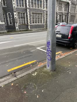 Graffiti —
Purple paint tag on concrete lamp pole on Montreal Street opposite the old teachers college.
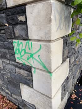 Graffiti —
Green and silver paint tags on concrete wall facing the footpath corner of Peterborough and Montreal Streets.
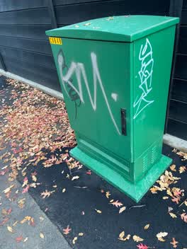 Graffiti —
White, black and silver paint tags on green CN848 asset on the corner of Peterborough and Montreal Streets.
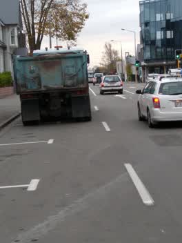 Roading/Streets —
For CTOC Shoulder used by cyclists on Victoria St detour route blocked by Fulton Hogan truck waiting to deliver gravel to site
Graffiti —
Lamp post
Also reported on Montreal Street
- 310 Montreal Street — 49 reports
- 262 Montreal Street — 48 reports
- 245 Montreal Street — 43 reports
- 325 Montreal Street — 39 reports
- 248 Montreal Street — 35 reports
- 327 Montreal Street — 34 reports
- 208 Montreal Street — 32 reports
- 338 Montreal Street — 30 reports
The street’s crash record
NZTA’s record names Montreal Street in 118 crashes that hurt somebody since 2006 — 18 seriously hurt, nobody killed.
The green nearby
- Victoria Triangles — 143 m to the edge
- Cranmer Square — 149 m to the edge · Botanic · 2 ha
- Hagley Park North — 207 m to the edge · Sports ground · 91 ha
- Aldred Reserve — 299 m to the edge
- Armagh Reserve — 375 m to the edge
Parks within half a kilometre, measured to the boundary — the council’s open data.
The civic shelf nearby
- Aldersgate — 358 m away · Car park
- Armagh St — 387 m away · Car park
Libraries, halls and the rest within half a kilometre — the council’s open data.
On the doorstep
- The Polo Bar at Hotel Montreal — 32 m away · Restaurants
- The Tack Rooms — 50 m away · Motels
- Black & White Coffee Cartel — 64 m away · Cafés
- Mr Sushi — 65 m away · Fast food
Businesses within four hundred metres, measured at the pin — OpenStreetMap and the council directories.
The bus nearby
- Victoria St near Peterborough St — 78 m away · route 1, route 29, route 95
- Salisbury St near Victoria St — 135 m away · route 1, route 29, route 95
The closest Metro stops, within four hundred and fifty metres.
The tracks through here
- Walk and bike track through Christchurch Central City — 74 m to the line · walk · bike
- Walk and bike track through Christchurch Central City — 201 m to the line · walk · bike
- Walk and bike track through Christchurch Central City — 211 m to the line · walk · bike
- Walk and bike track through Christchurch Central City — 213 m to the line · walk · bike
- Walk and bike track through Christchurch Central City — 228 m to the line · walk · bike
Tracks whose line passes within half a kilometre, measured to the line itself — the council’s open data.
The named ground
Named water within 500 m of this address, measured to the line or the edge; Named places within 1.5 km of this address; the council’s own structure register — bridges, boardwalks and steps standing nearby — the open map’s record.
The remembered names nearby
- Removed / From Intersection of / High & Manchester Streets — 69 m away ·
REMOVED / FROM INTERSECTION OF / HIGH & MANCHESTER STREETS / AND RE-ERECTED / OCTOBER 1990
· 2009 - Victoria Triangles plaque — 70 m away · 2009
- Diamondjubilee / 1837 - 1897 — 71 m away ·
DiamondJubilee / 1837 - 1897
· 2009
Inscribed plaques within two hundred and fifty metres — the register’s pins, not surveyed spots. The whole roll is at /plaques.
Renting nearby
new bonds in Christchurch Central City ran about $508 a week — $42 below the city median of $550 — the suburb page keeps the rent record →.
What was here — Victoria Mansions and Setting
47 m away · F/91 Victoria Street · located to ±21 m · the place’s own record →
On the register. Nothing researched here yet.
What was here — Former Christchurch Teachers College and Setting
56 m away · located to ±45 m · the place’s own record →
On the register. Nothing researched here yet.
What was here — Jubilee Clock Tower and Setting
71 m away · 95 Victoria Street · located to ±5 m · the place’s own record →
On the register. Nothing researched here yet.
What was here — Dwelling and Setting, Ironside House
84 m away · 32 Salisbury Street · located to ±15 m · the place’s own record →
On the register. Nothing researched here yet.
What was here — Former Shop/Dwelling and Setting
160 m away · 40 Cranmer Square · located to ±6 m · the place’s own record →
On the register. Nothing researched here yet.
The civic layer
This ground votes in Central ward — the Papanui-Innes-Central community board. Ward lines don’t always follow suburb lines; this one is measured at the pin, not the suburb’s centre.
What stood on this ground → · On the map → · From the air — the Crown’s aerials back to 1936; search the address on RetroLens →
Questions, answered briefly
18 council reports on record since February 2017 — most often graffiti (5), street gutters / storm water (2), graffiti on a fence, building or structure (2).
Christchurch Central City, Christchurch — on Montreal Street.
The heritage register names 5 places at or beside it — Victoria Mansions and Setting, Former Christchurch Teachers College and Setting.
Victoria Triangles — 143 m to its edge.