478 Hagley Avenue, Christchurch Central City
24 reports on record since June 2015 · 20 with photographs. The street’s heaviest record is 550 Hagley Avenue — 140 reports on file. Indicative rating valuation and school zones, hazards, bin day and what stood here before.
What gets reported here
Photographed here 20 on record


Reported here
 Graffiti on a sign, mural or public art —
multiple graffiti stickers on sign
 Trees - General —
Tree branches at head height protruding onto busy sidewalk - very hard to see now that there are no leaves on the tree and it gets dark quic
 Graffiti on a fence, building or structure —
Tagged street light (fence, building or structure)
 Pothole —
potholes
 Graffiti on a playground or in a park —
Tagging on entrance post to park near Selwyn street
 General Request —
A "reduced to clear" trolley abandoned
 Graffiti on a bus stop or public toilet —
On bus shelter and Seat opposite Hagley high school
 Graffiti on a cabinet, pole or railway asset —
 Graffiti on a sign, mural or public art —
 Graffiti on a sign, mural or public art —
Graffiti on both arrow signs and pedestrian rail bent
 Graffiti somewhere else —
Staggers have tagged the wall here
 Graffiti somewhere else —
Sign in centre island
 Graffiti —
478 Hagley ave
- Graffiti —
- Dumped Rubbish —
- Fallen Tree —
- Water Leak —
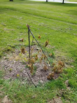 Parks —
Three newly planted trees in Hagley park have been snapped and need replacing. Looks like vandalism.
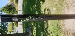 Graffiti —
another pole in same area. perimeter of Hagley Park walkway opposite Selwyn st
Roading/Streets —
another central median that is overlooked and soon to be one of our new 'Central Median Shrubbery'
Graffiti —
Graffiti —
Roading/Streets —
Drain Grate missing
Roading/Streets —
Give way sign on the corner of hagley ave and Selwyn st has been hit and bent to 45 degrees. Pole is bent at the base.
Also reported on Hagley Avenue
- 550 Hagley Avenue — 140 reports
- 510 Hagley Avenue — 100 reports
- 455 Hagley Avenue — 53 reports
- 445 Hagley Avenue — 34 reports
- 420 Hagley Avenue — 34 reports
- 510A Hagley Avenue — 31 reports
- 480–488 Hagley Avenue — 29 reports
- 447 Hagley Avenue — 18 reports
The street’s crash record
NZTA’s record names Hagley Avenue in 51 crashes that hurt somebody since 2006 — 13 seriously hurt, nobody killed.
The green nearby
- Hagley Park South — 369 m to the edge · Sports ground · 71 ha
- Nurses Memorial Chapel — 440 m to the edge · Botanic
Parks within half a kilometre, measured to the boundary — the council’s open data.
On the doorstep
- Hagley Theatre Company — 126 m away · Cinemas & theatres
- Coming: Health Precinct — 173 m away · Doctors & clinics
- Hagley Community College Pre-school — 183 m away · Business
- MIG Cars — 197 m away · Car dealers
Businesses within four hundred metres, measured at the pin — OpenStreetMap and the council directories.
The bus nearby
- Hagley Ave near Selwyn St — 73 m away · route 7, route 60, route 81
- Hagley Ave near Hagley High Sch — 90 m away · route 7, route 60, route 81, route 84, route 85
The closest Metro stops, within four hundred and fifty metres.
The tracks through here
- Walk and bike track through Christchurch Central City — 2 m to the line · walk · bike
- Walk and bike track through Christchurch Central City — 42 m to the line · walk · bike
- Walk and bike track through Christchurch Central City — 57 m to the line · walk · bike
- Walk and bike track through Christchurch Central City — 241 m to the line · walk · bike
- Walk and bike track through Christchurch Central City — 241 m to the line · walk · bike
Tracks whose line passes within half a kilometre, measured to the line itself — the council’s open data.
The named ground
Named water within 500 m of this address, measured to the line or the edge; Named places within 1.5 km of this address; the council’s own structure register — bridges, boardwalks and steps standing nearby — the open map’s record.
Renting nearby
new bonds in Christchurch Central City ran about $508 a week — $42 below the city median of $550 — the suburb page keeps the rent record →.
What was here — Former West Christchurch School/Hagley Community College and Setting
181 m away · 510E Hagley Avenue · located to ±63 m · the place’s own record →
On the register. Nothing researched here yet.
The civic layer
This ground votes in Central ward — the Papanui-Innes-Central community board. Ward lines don’t always follow suburb lines; this one is measured at the pin, not the suburb’s centre.
What stood on this ground → · On the map → · From the air — the Crown’s aerials back to 1936; search the address on RetroLens →
Questions, answered briefly
24 council reports on record since June 2015 — most often graffiti (5), roading/streets (3), graffiti on a sign, mural or public art (3).
Christchurch Central City, Christchurch — on Hagley Avenue.
The heritage register names a place at or beside it — Former West Christchurch School/Hagley Community College and Setting.
Hagley Park South — 369 m to its edge, 71 ha.