2 Tidal View
2 council reports since January 2021, 2 carrying a photograph. The street’s heaviest record is 4 Tidal View, 21 reports on file.
On the register here
- Former Dwelling and Setting, 2A Main Road (230m)
From the air, then
Sourced from Canterbury Maps and partners. RNZAF, CC BY 3.0 NZ. Each frame is cut from Environment Canterbury’s historic imagery MapServer for that decade, only where the Footprints layer names a CC BY survey (NZAM-covered spots stay out). RetroLens holds more Crown aerials →
The green nearby
- Settlers Reserve, 116 m to the edge · 13 ha
- Scott Park Ferrymead, 183 m to the edge · 2 ha
- Charlesworth Reserve, 365 m to the edge · Regional · 24 ha
- Te Awakura Reserve, 429 m to the edge
- Ferrymead Reserve, 455 m to the edge · Botanic · 1 ha
Parks within half a kilometre, measured to the boundary, the council’s open data. The whole roll is at /parks.
On the doorstep
- Connect Chiropractic, 25 m away · Alternative
- Anytime Fitness, 46 m away · Gyms & fitness
- Best Turkish Food Co., 61 m away · Restaurants
- The Kebab King Ferrymead, 65 m away · Fast food
Businesses within four hundred metres, measured at the pin, OpenStreetMap and the council directories.
The bus nearby
- Ferry Rd near Settlers Cres, 219 m away · route 3, route 140, route 155
- Ferry Rd near Settlers Cres, 221 m away · route 3, route 140, route 155
The closest Metro stops, within four hundred and fifty metres.
The tracks through here
- Walk and bike track through Ferrymead, 3 m to the line · walk · bike
- Walk and bike track through Ferrymead, 79 m to the line · walk · bike
- Walk and bike track through Ferrymead, 79 m to the line · walk · bike
- Walk and bike track through Ferrymead, 126 m to the line · walk · bike
- Walk and bike track through Ferrymead, 139 m to the line · walk · bike
Tracks whose line passes within half a kilometre, the council’s open data.
The named ground
Named water within 500 m of this address, measured to the line or the edge; the council’s own structure register, bridges, boardwalks and steps standing nearby, the open map’s record.
The remembered names nearby
- Christchurch / City Council / 1967 / H2o – S10 – T16, 113 m away ·
CHRISTCHURCH / CITY COUNCIL / 1967 / H2O – S10 – T16
· 1998 - Donated by Friends and Family / in Memory of / Keith Murray, 126 m away ·
Donated by friends and family / in memory of / Keith Murray / (1966 – 2005) / who loved th
· 2005
Inscribed plaques within two hundred and fifty metres, the register’s pins, not surveyed spots. The whole roll is at /plaques.
What gets reported here
- Roading/Streets, 1
- Parks, 1
Photographed here 2 on record
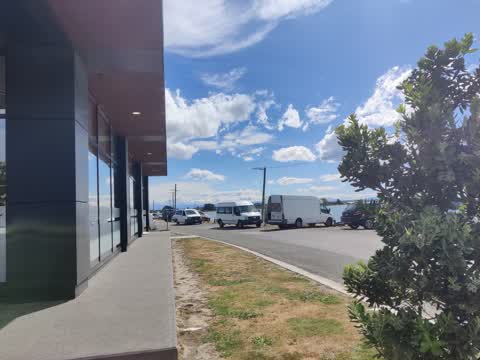
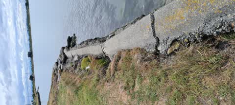
What’s on record
 Roading/Streets, 6 Mar 2021
 these two vehicles park on broken yellow lines every Saturday. This blocks the road itself.
 Parks, 21 Jan 2021
 large sections of the wall have fallen into the estuary and many more are eroded, dangerous and in danger of falling in also
Elsewhere on Tidal View
- 4 Tidal View, 21 reports
- 5 Tidal View, 15 reports
- 9 Tidal View, 9 reports
- 7 Tidal View, 4 reports
- 21E Tidal View, 4 reports
- 8 Tidal View, 2 reports
- 13 Tidal View, 2 reports
- 1 Tidal View, 2 reports
The street’s crash record
NZTA’s record names Tidal View in 4 crashes that hurt somebody since 2006, 1 seriously hurt, nobody killed.
The civic layer
This ground votes in Heathcote ward, the Spreydon-Cashmere-Heathcote community board is its local layer. Ward lines don’t always follow suburb lines; this one is measured at the pin, not the suburb’s centre. The whole roll is at /wards.
Tidal View, the whole record → · Everything about Ferrymead → · What stood on this ground → · On the map → · From the air, RetroLens holds the Crown’s aerials back to 1936; search the address there →
Questions, answered briefly
2 council reports on record since January 2021, most often roading/streets (1), parks (1).
Ferrymead, Christchurch, on Tidal View.
The heritage register names a place at or beside it, Former Dwelling and Setting.
Settlers Reserve, 116 m to its edge, 13 ha.