51 Bridle Path Road
8 council reports since November 2022, 7 carrying a photograph. The street’s heaviest record is 45 Bridle Path Road, 63 reports on file.
From the air, then
Sourced from Canterbury Maps and partners. RNZAF, CC BY 3.0 NZ. Each frame is cut from Environment Canterbury’s historic imagery MapServer for that decade, only where the Footprints layer names a CC BY survey (NZAM-covered spots stay out). RetroLens holds more Crown aerials →
The green nearby
- Heathcote Domain, you are in it · Sports ground · 4 ha · playground, 52 pieces
- Birdsey Reserve, 44 m to the edge · 3 ha
- Scotts Valley Reserve, 199 m to the edge · Regional · 130 ha
- Bridle Path Walkway, 297 m to the edge · Regional · 9 ha
- Castle Rock Reserve, 339 m to the edge · Regional · 89 ha
Parks within half a kilometre, measured to the boundary, the council’s open data. The whole roll is at /parks.
On the doorstep
- Heathcote Cricket Club, 147 m away · Clubs
- Christchurch Gondola, 376 m away · Attractions
- Red Rock Cafe, 378 m away · Restaurants
Businesses within four hundred metres, measured at the pin, OpenStreetMap and the council directories.
The bus nearby
- Bridle Path Rd near Port Hills Rd, 74 m away · route 8, route 155
- Bridle Path Rd near Port Hills Rd, 98 m away · route 8, route 155
The closest Metro stops, within four hundred and fifty metres.
The tracks through here
- Walk and bike track through Heathcote Valley, 329 m to the line · walk · bike
Tracks whose line passes within half a kilometre, the council’s open data.
The named ground
Named places within 1.5 km of this address; the council’s own structure register, bridges, boardwalks and steps standing nearby, the open map’s record.
The remembered names nearby
- Heathcote / Cricket Club / 2002 – 2003 / [ Small Text], 51 m away ·
HEATHCOTE / CRICKET CLUB / 2002 – 2003 / [illegible small text]
· 1899 - In Memory of / Roger Georgieff, 52 m away ·
In memory of/ ROGER GEORGIEFF/ Who lovingly tended this cricket ground for over 40 years/
· 2016 - Heathcote Domain plaque, 53 m away ·
(illegible – plaque partly obscured by foliage)
· 2013
Inscribed plaques within two hundred and fifty metres, the register’s pins, not surveyed spots. The whole roll is at /plaques.
Renting nearby
new bonds in Heathcote Valley ran about $750 a week, $200 above the city median of $550, the suburb page keeps the rent record →.
What gets reported here
Photographed here 7 on record


What’s on record
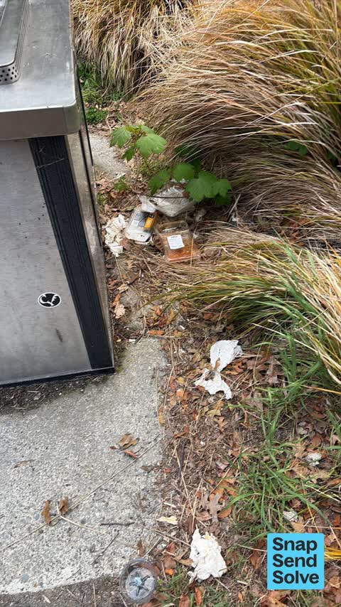
 Litter, 9 Oct 2026
 Litter behind BBQ, if there was a rubbish bin here maybe people would use it
 Bus Shelter Issue, 1 Sept 2026
 I do not know what it is, looks like a dark brown liquid poured or sprayed on the bus stop. I asked ChatGPT and it said it might be urine.
 Bus Shelter Issue, 14 Mar 2026
 Recently this bus shelter was hit by a bus trying to reverse so it could continue on its journey. The issue is that the shelter is too clos
 Graffiti on a fence, building or structure, 8 Dec 2025
 Please can you arrange removal of this tag? Many thanks!
 Hazard, vehicle, 19 May 2025
 Car repeatedly parked blocking the footpath
 Dumped Rubbish, 6 Oct 2024
 Burnt out van in the car park outside the heathcote sports club. Council property. Been there for weeks . Dangerous for children
 Park - General Request, 15 Aug 2024
 Hi there beside the Lampost there is a fire hydrant underneath a plywood cover. If this hydrant is operative can a sign be put on the Lampos
- Overgrown Vegetation, 17 Nov 2022
Elsewhere on Bridle Path Road
- 45 Bridle Path Road, 63 reports
- 60 Bridle Path Road, 18 reports
- 10 Bridle Path Road, 18 reports
- 111E Bridle Path Road, 14 reports
- 50 Bridle Path Road, 13 reports
- 111 Bridle Path Road, 12 reports
- 1 Bridle Path Road, 10 reports
- 96 Bridle Path Road, 9 reports
The street’s crash record
NZTA’s record names Bridle Path Road in 12 crashes that hurt somebody since 2006, 3 seriously hurt, nobody killed.
The civic layer
This ground votes in Heathcote ward, the Spreydon-Cashmere-Heathcote community board is its local layer. Ward lines don’t always follow suburb lines; this one is measured at the pin, not the suburb’s centre. The whole roll is at /wards.
Bridle Path Road, the whole record → · Everything about Heathcote Valley → · What stood on this ground → · On the map → · From the air, RetroLens holds the Crown’s aerials back to 1936; search the address there →
Questions, answered briefly
8 council reports on record since November 2022, most often bus shelter issue (2), park - general request (1), overgrown vegetation (1).
Heathcote Valley, Christchurch, on Bridle Path Road.
Nothing on the heritage register at this exact spot, the record around this ground →
Heathcote Domain, the address is inside it, 4 ha.