26A Oxford Street, Lyttelton
21 reports on record since September 2020 · 17 with photographs. The street’s heaviest record is 26 Oxford Street — 83 reports on file. Indicative rating valuation and school zones, hazards, bin day and what stood here before.
What gets reported here
Photographed here 17 on record


Reported here
 Graffiti on a playground or in a park —
 Graffiti spreading
- Graffiti on a playground or in a park —
Graffiti
 Graffiti on a fence, building or structure —
 Graffiti
 Graffiti on a fence, building or structure —
  Graffiti on a fence, building or structure —
 Please arrange removal of this tag.
 Graffiti on a fence, building or structure —
 Seeking your help (again) to arrange removal of these tags - many thanks!
 Graffiti on a traffic light pole or cabinet, or wa —
 Seeking your help to remove this tag - many thanks!
 Graffiti on a fence, building or structure —
 Please could you arrange removal of this tag - many thanks!
 Graffiti on a playground or in a park —
 Fresh graffiti on wall
 Graffiti on a fence, building or structure —
  Graffiti on a playground or in a park —
 New graffiti on wall
 Park - General Request —
 Grassy entrance needs attention - added soil due to water flooding
 Graffiti on a fence, building or structure —
 Tagging by muppets on playground historic walls
 Graffiti on a fence, building or structure —
 Lots of graffiti on a wall
 Graffiti on a playground or in a park —
 New graffiti on concrete wall needs removing
- Graffiti —
- Graffiti —
- Bus Shelter Issue —
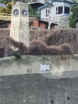 Graffiti —
 Roading/Streets —
Outside Lyttelton Primary school - there are yellow lines and still white parking lines too.
Graffiti —
Also reported on Oxford Street
- 26 Oxford Street — 83 reports
- 54 Oxford Street — 71 reports
- 6 Oxford Street — 35 reports
- 24 Oxford Street — 28 reports
- 20 Oxford Street — 27 reports
- 18 Oxford Street — 12 reports
- 25 Oxford Street — 10 reports
- 54A Oxford Street — 9 reports
The street’s crash record
NZTA’s record names Oxford Street in 3 crashes that hurt somebody since 2006 — 1 seriously hurt, nobody killed.
The green nearby
- Oxford Street Reserve — 10 m to the edge · Botanic
- Sumner Road Gardens — 101 m to the edge
- Baden Norris Reserve — 123 m to the edge
- Albion Square — 208 m to the edge · Botanic
- Urumau Reserve — 233 m to the edge · Regional · 26 ha
Parks within half a kilometre, measured to the boundary — the council’s open data.
The civic shelf nearby
- Lyttelton Cemetery — 160 m away · Cemetery
- Lyttelton Service Centre — 187 m away · Service centre
- Lyttelton Library — 207 m away · Library · 29 Winchester St, Lyttelton 8082
- Lyttelton Anglican Cemetery — 334 m away · Cemetery
Libraries, halls and the rest within half a kilometre — the council’s open data.
On the doorstep
- Everest Indian Restaurant & Takeaway — 84 m away · Restaurants
- The Garage Sale — 84 m away · Op shops
- Everest — 86 m away · Restaurants
- Lyttelton Arts Factory (Laf) — 87 m away · Cinemas & theatres
Businesses within four hundred metres, measured at the pin — OpenStreetMap and the council directories.
The bus nearby
- Oxford Street near Winchester Street — 20 m away · route 8, route 155
- Norwich Quay near Canterbury St — 246 m away · route 8, route 155
The closest Metro stops, within four hundred and fifty metres.
The named ground
Named places within 1.5 km of this address; the council’s own structure register — bridges, boardwalks and steps standing nearby — the open map’s record.
The remembered names nearby
- Opened 1928 F. E. Sutton Mayor — 27 m away ·
OPENED 1928 F. E. SUTTON MAYOR
· 2008 - Lyttelton Gaol on This Site Stood the Infamous Lyttelton — 33 m away ·
LYTTELTON GAOL ON THIS SITE STOOD THE INFAMOUS LYTTELTON GAOL BUILT IN 1851 AS A WOODEN LO
· 2008 - Erected in Grateful Memory of Charles Hazlitt Upham Mrcs — 68 m away ·
ERECTED IN GRATEFUL MEMORY OF CHARLES HAZLITT UPHAM MRCS LRCP (THE LITTLE DOCTOR) 1863 - 1
· 2008
Inscribed plaques within two hundred and fifty metres — the register’s pins, not surveyed spots. The whole roll is at /plaques.
Renting nearby
new bonds in Lyttelton ran about $600 a week — $50 above the city median of $550 — the suburb page keeps the rent record →.
What was here — Former Warder's House and Setting
34 m away · 39 Oxford Street · located to ±11 m · the place’s own record →
On the register. Nothing researched here yet.
What was here — Cobblestone Gutters and Setting
on this spot · located to ±116 m · the place’s own record →
On the register. Nothing researched here yet.
What was here — Former Lyttelton Gaol Site
on this spot · 26D Oxford Street · located to ±55 m · the place’s own record →
On the register. Nothing researched here yet.
What was here — Dwelling and Setting
52 m away · 3 Winchester Street · located to ±11 m · the place’s own record →
On the register. Nothing researched here yet.
What was here — Former Lyttelton Police Station Cells and Setting
72 m away · 5 Sumner Road · located to ±11 m · the place’s own record →
On the register. Nothing researched here yet.
The civic layer
This ground votes in Banks Peninsula ward — the Banks Peninsula community board. Ward lines don’t always follow suburb lines; this one is measured at the pin, not the suburb’s centre.
What stood on this ground → · On the map → · From the air — the Crown’s aerials back to 1936; search the address on RetroLens →
Questions, answered briefly
21 council reports on record since September 2020 — most often graffiti on a fence, building or structure (8), graffiti on a playground or in a park (5), graffiti (4).
Lyttelton, Christchurch — on Oxford Street.
The heritage register names 5 places at or beside it — Former Warder's House and Setting, Cobblestone Gutters and Setting.
Oxford Street Reserve — 10 m to its edge.