10 Main Road, Mount Pleasant
23 reports on record since January 2022 · 18 with photographs. The street’s heaviest record is 62 Main Road — 30 reports on file. Indicative rating valuation and school zones, hazards, bin day and what stood here before.
What gets reported here
Photographed here 18 on record


Reported here
 Pavement - Damaged —
 This foot path is on St Andrews Hill Rd Mt Pleasant. It is uneven, narrow & dangerous for pedestrians as it is a trip hazard.
 Park - General Request —
 Overnight camping is growing in Scott Park. I don't believe this is a permitted activity. Also, I don't believe the gate is being locked acc
 Trees - General —
 Trees need cutting back off footpath
 Water Leak —
 Suspected water leak
 Dumped Rubbish —
 I know it's not rubbish. Water has been coming out of storm water pipe for more than a month. Allan 021 361 434
 Water General —
 Continual/sporadic discharge of water from adjacent facility-the road is wet 100% of the time and is a hazard(slippery when cold and will gr
 Damaged Road —
 There has been a leak out of the road here for a while
 Water Leak —
 Water pouring out of storm water into road, outside telephone exchange, running down to a drain which is full. It has been like this for a l
- Water Leak —
 Water Leak —
 This water leak has been going for weeks now. Needs sorting.
- Water General —
Re previous snap 4978795 Water is still pouring continuously out onto the gutter, i think fro.a stormwater pipe. There has been no rain for
 Flooding —
 The drain is increasing its discharge of this huge amount of water over the road causing a traffic hazard
- Water General —
For days now there has been water leaking onto the road. It appears to be coming out of a drain pipe on the kerb.
 Street Gutters / Storm Water —
 This has been leaking for several weeks already and as it's on a busy road I'm surprised that council workers haven't reported it.
 Water Leak —
  Pavement - Damaged —
 Potholes to level fill & seal & cones to remove. Concrete foundation surrounding old empty building potholes & re leveling & cone to remove
 Water Leak —
 Water leaking out of path...
 Water Leak —
 Leak from meter on council property
 Water Leak —
  Water Leak —
 Leaking submain
- Water Leak —
- Water Leak —
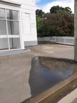 Water Leak —
 There's another one leaking 50m down the road towards Redcliffs too. This one is pouring at quite a rate
Also reported on Main Road
- 62 Main Road — 30 reports
- 28 Main Road — 16 reports
- 12 Main Road — 16 reports
- 32 Main Road — 14 reports
- 24 Main Road — 13 reports
- 2A Main Road — 11 reports
- 2 Main Road — 10 reports
- 10A Main Road — 10 reports
The street’s crash record
NZTA’s record names Main Road in 33 crashes that hurt somebody since 2006 — 1 person killed, 10 seriously hurt.
The green nearby
- Scott Park Ferrymead — 52 m to the edge · 2 ha
- Te Awakura Reserve — 170 m to the edge
- Settlers Reserve — 227 m to the edge · 13 ha
- The Brae — 268 m to the edge
- Ferrymead Reserve — 422 m to the edge · Botanic · 1 ha
Parks within half a kilometre, measured to the boundary — the council’s open data.
On the doorstep
- Connect Chiropractic — 276 m away · Alternative
- Anytime Fitness — 281 m away · Gyms & fitness
- The Kebab King Ferrymead — 281 m away · Fast food
- Best Turkish Food Co. — 285 m away · Restaurants
Businesses within four hundred metres, measured at the pin — OpenStreetMap and the council directories.
The bus nearby
- Main Rd near St Andrews Hill Rd — 43 m away · route 3
- Main Rd near Te Awakura Tce — 76 m away · route 3
The closest Metro stops, within four hundred and fifty metres.
The tracks through here
- Walk and bike track through Mount Pleasant — 7 m to the line · walk · bike
- Walk and bike track through Mount Pleasant — 7 m to the line · walk · bike
- Walk and bike track through Mount Pleasant — 61 m to the line · walk · bike
- Walk and bike track through Mount Pleasant — 231 m to the line · walk · bike
- Walk and bike track through Mount Pleasant — 254 m to the line · walk · bike
Tracks whose line passes within half a kilometre, measured to the line itself — the council’s open data.
The named ground
Named water within 500 m of this address, measured to the line or the edge; the council’s own structure register — bridges, boardwalks and steps standing nearby — the open map’s record.
The remembered names nearby
- Christchurch / City Council / 1967 / H2o – S10 – T16 — 190 m away ·
CHRISTCHURCH / CITY COUNCIL / 1967 / H2O – S10 – T16
· 1998
Inscribed plaques within two hundred and fifty metres — the register’s pins, not surveyed spots. The whole roll is at /plaques.
Renting nearby
new bonds in Mount Pleasant ran about $700 a week — $150 above the city median of $550 — the suburb page keeps the rent record →.
What was here — Former Dwelling and Setting
41 m away · 2A Main Road · located to ±7 m · the place’s own record →
On the register. Nothing researched here yet.
The civic layer
This ground votes in Heathcote ward — the Spreydon-Cashmere-Heathcote community board. Ward lines don’t always follow suburb lines; this one is measured at the pin, not the suburb’s centre.
What stood on this ground → · On the map → · From the air — the Crown’s aerials back to 1936; search the address on RetroLens →
Questions, answered briefly
23 council reports on record since January 2022 — most often water leak (12), water general (3), pavement - damaged (2).
Mount Pleasant, Christchurch — on Main Road.
The heritage register names a place at or beside it — Former Dwelling and Setting.
Scott Park Ferrymead — 52 m to its edge, 2 ha.