32 Main Road, Mount Pleasant
14 reports on record since November 2021 · 14 with photographs. The street’s heaviest record is 62 Main Road — 30 reports on file. Indicative rating valuation and school zones, hazards, bin day and what stood here before.
What gets reported here
Photographed here 14 on record




Reported here
 Hazard — vehicle —
 I walk past here most days I cannot remember when this car was not parked on the footpath. There is enough gap for a person to pass, but n
 Road Signage —
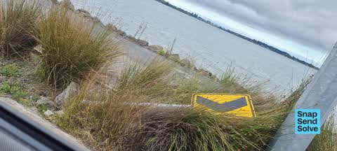
 safety sign is down again. I think is is probably the 7th time I have reported. Just standing it up again does not work. It requires a new c
 Road Signage —
 I think this is about the 6th time I have reported this safety sign as being down. Each time it has been stood back up with no attention to
 Road Signage —
 Chevron sign lying down
 Road Signage —
 safety marker down. last one heading to Redcliffs. needs a proper repair (new concrete) at the base.
 Road Signage —
 reported previously... Road safety sign needs a new concrete base.. (not just standing back up). now a hazard in the shared cycleway / walki
 Poles and Signage - General —
 This is the last Safety Sign on the left heading to Sumner after Scott Park. The concrete base has pulled out of the ground. Ive reported it
 Road Signage —
 Safety sign blown over. I've reported at least twice before. Needs concrete base re doing. Also last picture is of sign missing - next one t
 Road Signage —
 Hi - reported this before... safety signage is over. Needs new concrete base. Also added into this report that same signage is missing about
 Road Signage —
 Safety sign snapped off... no sign of sign ??
 Road Signage —
 Hi. I submitted this a couple of weeks back and it appeared it was stood back up in its existing hole. There's a block of concrete on the bo
 Road Signage —
 Safety sign needs putting back in place pls.
 Road Signage —
 Old road signage to remove & weeding required along cycle way to sumner
 Wastewater/Stormwater —
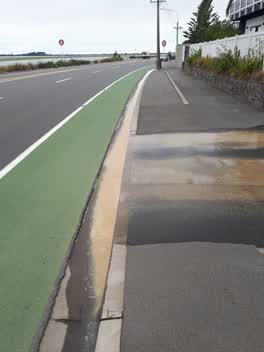
 Major sediment to stormwater and estuary
Also reported on Main Road
- 62 Main Road — 30 reports
- 10 Main Road — 22 reports
- 28 Main Road — 16 reports
- 12 Main Road — 16 reports
- 24 Main Road — 13 reports
- 2A Main Road — 11 reports
- 2 Main Road — 10 reports
- 10A Main Road — 10 reports
The street’s crash record
NZTA’s record names Main Road in 33 crashes that hurt somebody since 2006 — 1 person killed, 10 seriously hurt.
The green nearby
- Scott Park Ferrymead — 12 m to the edge · 2 ha
- The Brae — 61 m to the edge
- Te Awakura Reserve — 243 m to the edge
- King Park — 274 m to the edge · 2 ha
- Settlers Reserve — 445 m to the edge · 13 ha
Parks within half a kilometre, measured to the boundary — the council’s open data.
The bus nearby
The closest Metro stops, within four hundred and fifty metres.
The tracks through here
- Walk and bike track through Mount Pleasant — 10 m to the line · walk · bike
- Walk and bike track through Mount Pleasant — 10 m to the line · walk · bike
- Walk and bike track through Mount Pleasant — 137 m to the line · walk · bike
- Walk and bike track through Mount Pleasant — 288 m to the line · walk · bike
- Walk and bike track through Mount Pleasant — 427 m to the line · walk · bike
Tracks whose line passes within half a kilometre, measured to the line itself — the council’s open data.
The named ground
Named water within 500 m of this address, measured to the line or the edge; the council’s own structure register — bridges, boardwalks and steps standing nearby — the open map’s record.
The remembered names nearby
- Jonathan McGregor Smith / on Mt. D’Archiac — 123 m away ·
JONATHAN McGREGOR SMITH / on Mt. D’Archiac / May 6th 1955 – June 1st 2003 / Grandson of Ro
· 2009
Inscribed plaques within two hundred and fifty metres — the register’s pins, not surveyed spots. The whole roll is at /plaques.
Renting nearby
new bonds in Mount Pleasant ran about $700 a week — $150 above the city median of $550 — the suburb page keeps the rent record →.
The civic layer
This ground votes in Heathcote ward — the Spreydon-Cashmere-Heathcote community board. Ward lines don’t always follow suburb lines; this one is measured at the pin, not the suburb’s centre.
What stood on this ground → · On the map → · From the air — the Crown’s aerials back to 1936; search the address on RetroLens →
Questions, answered briefly
14 council reports on record since November 2021 — most often road signage (11), wastewater/stormwater (1), poles and signage - general (1).
Mount Pleasant, Christchurch — on Main Road.
Nothing on the heritage register at this exact spot — the record around this ground →
Scott Park Ferrymead — 12 m to its edge, 2 ha.