386A Estuary Road, South New Brighton
18 reports on record since September 2015 · 18 with photographs. The street’s heaviest record is 222 Estuary Road — 33 reports on file. Indicative rating valuation and school zones, hazards, bin day and what stood here before.
What gets reported here
- Graffiti on a fence, building or structure — 9
- Graffiti — 5
- Pest / Vermin — 1
- Pavement - Damaged — 1
- Graffiti somewhere else — 1
- Facility - General Request — 1
Photographed here 18 on record

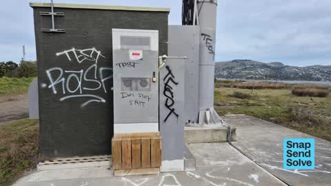


Reported here
 Graffiti on a fence, building or structure —
 tagging
 Graffiti on a fence, building or structure —
 tagging spray tag sharpie pen
 Graffiti on a fence, building or structure —
 written with sharpie pen or permanent pen...
 Facility - General Request —
 Boardwalk at south end of south brighton estuary edge walkway damaged by recent storm, needs resetting please
 Pavement - Damaged —
 The south brighton boardwalk has come off its posts. It's ripped apart.
 Graffiti on a fence, building or structure —
 Tags on kordia tower & building In estuary walkway
 Graffiti on a fence, building or structure —
  Graffiti on a fence, building or structure —
 Phone tower
 Graffiti on a fence, building or structure —
  Graffiti on a fence, building or structure —
 On tower and building
 Graffiti on a fence, building or structure —
 Tags on cell tower building Kordia
 Graffiti somewhere else —
 Tagging on cell tower base
 Pest / Vermin —
 I think the rodent trap has been dislodged by the tide?
Graffiti —
Can we please have this removed??
Graffiti —
Still there...
Graffiti —
South brighton reserve
Graffiti —
Graffiti —
Also reported on Estuary Road
- 222 Estuary Road — 33 reports
- 204B Estuary Road — 27 reports
- 404 Estuary Road — 20 reports
- 392A Estuary Road — 19 reports
- 190 Estuary Road — 19 reports
- 236 Estuary Road — 15 reports
- 402 Estuary Road — 13 reports
- 239 Estuary Road — 11 reports
The street’s crash record
NZTA’s record names Estuary Road in 17 crashes that hurt somebody since 2006 — 3 people killed, 5 seriously hurt.
The green nearby
- South New Brighton Park — you are in it · Sports ground · 30 ha
Parks within half a kilometre, measured to the boundary — the council’s open data.
On the doorstep
- S Brighton Holiday Park — 303 m away · Campgrounds
- South New Brighton Holiday Park — 337 m away · Campgrounds
Businesses within four hundred metres, measured at the pin — OpenStreetMap and the council directories.
The bus nearby
The closest Metro stops, within four hundred and fifty metres.
The tracks through here
- Walk and bike track through South New Brighton — 54 m to the line · walk · bike
Tracks whose line passes within half a kilometre, measured to the line itself — the council’s open data.
The named ground
Named places within 1.5 km of this address; the council’s own structure register — bridges, boardwalks and steps standing nearby — the open map’s record.
The remembered names nearby
- South New Brighton Park plaque — 214 m away
Inscribed plaques within two hundred and fifty metres — the register’s pins, not surveyed spots. The whole roll is at /plaques.
Renting nearby
new bonds in South New Brighton ran about $640 a week — $90 above the city median of $550 — the suburb page keeps the rent record →.
The civic layer
This ground votes in Coastal ward — the Coastal-Burwood-Linwood community board. Ward lines don’t always follow suburb lines; this one is measured at the pin, not the suburb’s centre.
What stood on this ground → · On the map → · From the air — the Crown’s aerials back to 1936; search the address on RetroLens →
Questions, answered briefly
18 council reports on record since September 2015 — most often graffiti on a fence, building or structure (9), graffiti (5), pest / vermin (1).
South New Brighton, Christchurch — on Estuary Road.
Nothing on the heritage register at this exact spot — the record around this ground →
South New Brighton Park — the address is inside it, 30 ha.