404 Estuary Road, South New Brighton
20 reports on record since March 2020 · 14 with photographs. The street’s heaviest record is 222 Estuary Road — 33 reports on file. Indicative rating valuation and school zones, hazards, bin day and what stood here before.
What gets reported here
- Graffiti — 7
- Graffiti somewhere else — 3
- Dumped Rubbish — 3
- Rubbish/Recycling — 1
- Pothole — 1
- Pit and Equipment - General — 1
Photographed here 14 on record


Reported here
 Abandoned Vehicle —
Bus, doesn't appear to have warrant or registration has been parked at end of Estuary Road carpark by cellphone tower for a few days.
- Dumped Rubbish —
some useless idiot has dumped a significant amount of their rubbish by / and bear the bin ( 2 piles )
 Dumped Rubbish —
Statues dumped in estuary by small jetty
 Dumped Rubbish —
Around rubbish bin at Estuary Rd and ebbtide st carpark, near start of boardwalk
 Litter —
Looks like trash from a car or maybe from stolen property
 Graffiti on a fence, building or structure —
 Pothole —
Lots of pot holes in carpark
 Graffiti somewhere else —
 Graffiti somewhere else —
 Graffiti somewhere else —
- Graffiti —
- Pit and Equipment - General —
- Graffiti —
- Graffiti —
- Graffiti —
 Graffiti —
 Park - General Request —
This car has been camping here for over a week
 Graffiti —
Obviously cannot spell!!!! :)
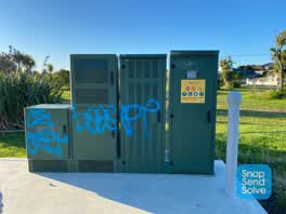 Graffiti —
Rubbish/Recycling —
trash dumped
Also reported on Estuary Road
- 222 Estuary Road — 33 reports
- 204B Estuary Road — 27 reports
- 392A Estuary Road — 19 reports
- 190 Estuary Road — 19 reports
- 386A Estuary Road — 18 reports
- 236 Estuary Road — 15 reports
- 402 Estuary Road — 13 reports
- 239 Estuary Road — 11 reports
The street’s crash record
NZTA’s record names Estuary Road in 17 crashes that hurt somebody since 2006 — 3 people killed, 5 seriously hurt.
The green nearby
- South New Brighton Park — 81 m to the edge · Sports ground · 30 ha
Parks within half a kilometre, measured to the boundary — the council’s open data.
The bus nearby
The closest Metro stops, within four hundred and fifty metres.
The tracks through here
- Walk and bike track through South New Brighton — 97 m to the line · walk · bike
Tracks whose line passes within half a kilometre, measured to the line itself — the council’s open data.
The named ground
Named places within 1.5 km of this address; the council’s own structure register — bridges, boardwalks and steps standing nearby — the open map’s record.
Renting nearby
new bonds in South New Brighton ran about $640 a week — $90 above the city median of $550 — the suburb page keeps the rent record →.
The civic layer
This ground votes in Coastal ward — the Coastal-Burwood-Linwood community board. Ward lines don’t always follow suburb lines; this one is measured at the pin, not the suburb’s centre.
What stood on this ground → · On the map → · From the air — the Crown’s aerials back to 1936; search the address on RetroLens →
Questions, answered briefly
20 council reports on record since March 2020 — most often graffiti (7), graffiti somewhere else (3), dumped rubbish (3).
South New Brighton, Christchurch — on Estuary Road.
Nothing on the heritage register at this exact spot — the record around this ground →
South New Brighton Park — 81 m to its edge, 30 ha.