20 Worcester Street, Christchurch Central City
24 reports on record since July 2022 · 12 with photographs. The street’s heaviest record is 142 Worcester Street — 103 reports on file. Indicative rating valuation and school zones, hazards, bin day and what stood here before.
What gets reported here
- Graffiti — 7
- General Request — 4
- Graffiti on a fence, building or structure — 3
- Road Blockage — 2
- Graffiti somewhere else — 2
- Vandalism - General — 1
Photographed here 12 on record



Reported here
 Graffiti on a fence, building or structure —
Graffiti on phone box
 Graffiti on a sign, mural or public art —
Graffiti on a sign
 Pavement - Damaged —
There is a board missing on a manhole that needs replacing urgently.
 Rubbish and Bins - General —
- Graffiti on a fence, building or structure —
Black paint tag on side of concrete rubbish bin by 20 Worcester Street.
 General Request —
Hi. One of many sites that have road cones that have not been collected. I was told to report abandoned road cones under the roads and signa
 Graffiti on a fence, building or structure —
 Road Blockage —
A week has gone by .. no action?
 Road Blockage —
 Graffiti somewhere else —
GNOME white paint tag on tree trunk by 20 Worcester Street. Hope this awful tag can be removed?
 Vandalism - General —
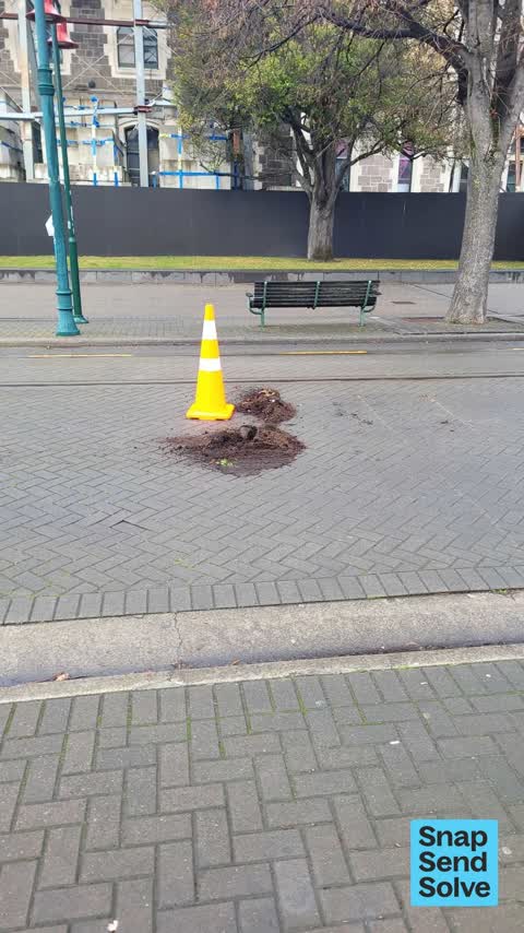
Planting box moved and some contents dumped onto road. Road cone also put there to mark? Not blocking tramp, but Inconvenience for motorists
 Graffiti on a cabinet, pole or railway asset —
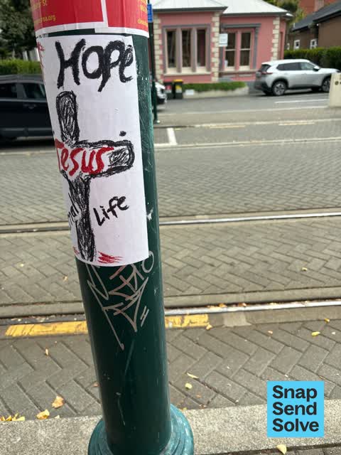
Silver paint tag (plus sticky tags) on tram pole by 20 Worcester Street.
 Graffiti somewhere else —
White paint tag on tree trunk by 20 Worcester Street. Here’s hoping it can be removed (the tag, not the tree!)
- General Request —
- General Request —
- Graffiti —
- Graffiti —
- Graffiti —
- General Request —
- Graffiti —
- Graffiti —
- Graffiti —
- Graffiti —
- Roading/Streets —
I don’t have any photos sorry but I was using an e scooter this morning coming down Worcester, just by where the work site entrance is for t
Also reported on Worcester Street
- 142 Worcester Street — 103 reports
- 3 Worcester Street — 78 reports
- 78 Worcester Street — 69 reports
- 67 Worcester Street — 60 reports
- 138 Worcester Street — 60 reports
- 151 Worcester Street — 50 reports
- 40 Worcester Street — 40 reports
- 154 Worcester Street — 34 reports
The street’s crash record
NZTA’s record names Worcester Street in 64 crashes that hurt somebody since 2006 — 9 seriously hurt, nobody killed.
The green nearby
- Botanic Gardens — 127 m to the edge · Botanic · 21 ha
- Hagley Park North — 262 m to the edge · Sports ground · 91 ha
- Armagh Reserve — 263 m to the edge
- Cranmer Square — 278 m to the edge · Botanic · 2 ha
- Scott Statue Reserve — 379 m to the edge · Botanic
Parks within half a kilometre, measured to the boundary — the council’s open data.
The civic shelf nearby
- Rolleston Avenue — 84 m away · Car park
- Civic Offices — 250 m away · Council office
- Scales — 319 m away · Car park
- Armagh St — 433 m away · Car park
- Christchurch Hospital Grounds — 434 m away · Car park
- Aldersgate — 490 m away · Car park
Libraries, halls and the rest within half a kilometre — the council’s open data.
On the doorstep
- Paint 'n' Sip Studio — 26 m away · Bars & pubs
- Opening 2022: Boutique Arts Hotel — 27 m away · Venues & events
- The Arts Centre Walking Tours — 30 m away · Attractions
- The Classic Villa — 35 m away · Hotels
Businesses within four hundred metres, measured at the pin — OpenStreetMap and the council directories.
The bus nearby
- Rolleston Ave near Gloucester St — 128 m away · route 8
- Rolleston Ave near Gloucester St — 195 m away · route 8
The closest Metro stops, within four hundred and fifty metres.
The tracks through here
- Walk and bike track through Christchurch Central City — 6 m to the line · walk · bike
- Walk and bike track through Christchurch Central City — 139 m to the line · walk · bike
- Walk and bike track through Christchurch Central City — 181 m to the line · walk · bike
- Walk and bike track through Christchurch Central City — 233 m to the line · walk · bike
- Walk and bike track through Christchurch Central City — 247 m to the line · walk · bike
Tracks whose line passes within half a kilometre, measured to the line itself — the council’s open data.
The named ground
Named water within 500 m of this address, measured to the line or the edge; Named places within 1.5 km of this address; the council’s own structure register — bridges, boardwalks and steps standing nearby — the open map’s record.
The remembered names nearby
- Botanic Gardens — 120 m away ·
BOTANIC GARDENS / THIS FENCE, ERECTED TO COMMEMORATE THE CENTENARY OF THE BOTANIC GARDENS
· 2004 - Botanic Gardens — 122 m away ·
BOTANIC GARDENS / ADMINISTERED BY THE CHRISTCHURCH DOMAINS BOARD UNTIL 1946 AND SINCE BY T
· 2004 - Christchurch Botanic Gardens - Donated by Llewellyn — 123 m away ·
CHRISTCHURCH BOTANIC GARDENS - DONATED BY LLEWELLYN J MITCHELL
· 1998
Inscribed plaques within two hundred and fifty metres — the register’s pins, not surveyed spots. The whole roll is at /plaques.
Renting nearby
new bonds in Christchurch Central City ran about $508 a week — $42 below the city median of $550 — the suburb page keeps the rent record →.
What was here — Hydraulic Laboratory, School of Engineering, and Setting
26 m away · 28 Worcester Street · located to ±17 m · the place’s own record →
On the register. Nothing researched here yet.
What was here — Mechanical Laboratory, School of Engineering, and Setting
30 m away · located to ±14 m · the place’s own record →
On the register. Nothing researched here yet.
What was here — Dwelling and Setting
43 m away · 15 Worcester Street · located to ±14 m · the place’s own record →
On the register. Nothing researched here yet.
What was here — Former Dwelling and Setting
44 m away · 17 Worcester Street · located to ±21 m · the place’s own record →
On the register. Nothing researched here yet.
What was here — Electrical Engineering Laboratory, School of Engineering, and Setting
45 m away · 13 Hereford Street · located to ±16 m · the place’s own record →
On the register. Nothing researched here yet.
The civic layer
This ground votes in Central ward — the Papanui-Innes-Central community board. Ward lines don’t always follow suburb lines; this one is measured at the pin, not the suburb’s centre.
What stood on this ground → · On the map → · From the air — the Crown’s aerials back to 1936; search the address on RetroLens →
Questions, answered briefly
24 council reports on record since July 2022 — most often graffiti (7), general request (4), graffiti on a fence, building or structure (3).
Christchurch Central City, Christchurch — on Worcester Street.
The heritage register names 5 places at or beside it — Hydraulic Laboratory, School of Engineering, and Setting, Mechanical Laboratory, School of Engineering, and Setting.
Botanic Gardens — 127 m to its edge, 21 ha.