315 Manchester Street, Christchurch Central City
11 reports on record since August 2015 · 7 with photographs. The street’s heaviest record is 297-299 Manchester Street — 102 reports on file. Indicative rating valuation and school zones, hazards, bin day and what stood here before.
What gets reported here
Photographed here 7 on record



Reported here
 Rubbish and Bins - General —
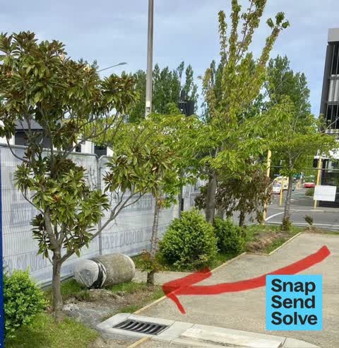
Rubbish bin at bus stop has been knocked over and is now in the road. either hit by a car or pushed over by a very strong person
 Graffiti on a traffic light pole or cabinet, or wa —
Black paint tag on traffic controller at 315 Manchester Street corner of Kilmore Street.
 Graffiti somewhere else —
 Rubbish and Bins - General —
Can you please get the bin on the corner of Kilmore and Manchester Street (north west corner) reinstated the contractor doing the paving on
 Vandalism - General —
- Graffiti —
- Graffiti —
- Graffiti —
- Graffiti —
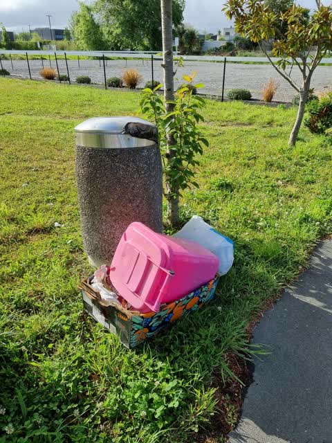
 Rubbish/Recycling —
Dumped 5.50pm Sat 13 Nov. Man in white car EZA950
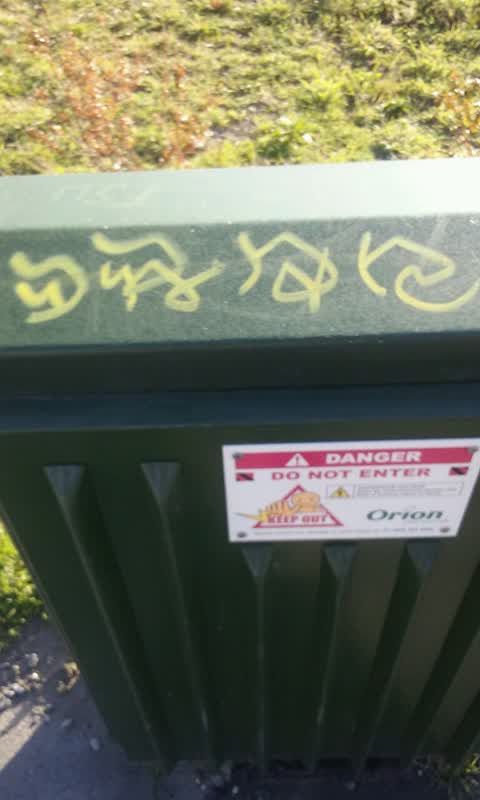
Graffiti —
Mid green Orion
Also reported on Manchester Street
- 297-299 Manchester Street — 102 reports
- 293 Manchester Street — 72 reports
- 214 Manchester Street — 72 reports
- 153 Manchester Street — 52 reports
- 218 Manchester Street — 48 reports
- 76 Manchester Street — 45 reports
- 204 Manchester Street — 45 reports
- 192 Manchester Street — 40 reports
The street’s crash record
NZTA’s record names Manchester Street in 235 crashes that hurt somebody since 2006 — 1 person killed, 38 seriously hurt.
The green nearby
- Edmonds Band Rotunda — 146 m to the edge · Botanic
- Cambridge Reserve — 180 m to the edge
- Poplars Reserve — 217 m to the edge · Botanic
- Victoria Square — 260 m to the edge · Botanic · 2 ha
- Fire Fighters Reserve — 268 m to the edge
Parks within half a kilometre, measured to the boundary — the council’s open data.
The civic shelf nearby
- Turanga Library — 451 m away · Library · Cathedral Square, Christchurch
Libraries, halls and the rest within half a kilometre — the council’s open data.
On the doorstep
- Forte 2 — 89 m away · Doctors & clinics
- Urology Associates — 136 m away · Doctors & clinics
- Forte Health — 140 m away · Hospital
- Southern Eye Speicalists — 142 m away · Doctors & clinics
Businesses within four hundred metres, measured at the pin — OpenStreetMap and the council directories.
The bus nearby
- Manchester St near Kilmore St — 13 m away · route 44, route 91, route 92
- Manchester St near Kilmore St — 29 m away · route 1, route 27, route 29, route 44, route 91, route 92, route 95
The closest Metro stops, within four hundred and fifty metres.
The tracks through here
- Walk and bike track through Christchurch Central City — 9 m to the line · walk · bike
- Walk and bike track through Christchurch Central City — 192 m to the line · walk · bike
- Walk and bike track through Christchurch Central City — 253 m to the line · walk · bike
- Walk and bike track through Christchurch Central City — 255 m to the line · walk · bike
- Walk and bike track through Christchurch Central City — 260 m to the line · walk · bike
Tracks whose line passes within half a kilometre, measured to the line itself — the council’s open data.
The named ground
Named water within 500 m of this address, measured to the line or the edge; Named places within 1.5 km of this address; the council’s own structure register — bridges, boardwalks and steps standing nearby — the open map’s record.
The remembered names nearby
- This Rotunda Shelter and Circular Seat Were Presented — 165 m away ·
THIS ROTUNDA SHELTER AND CIRCULAR SEAT WERE PRESENTED BY T.J. EDMONDS TO CELEBRATE FIFTY Y
· 2009 - Poplar Crescent 1929 — 172 m away ·
POPLAR CRESCENT 1929
· 2009 - Scottish Pioneer Tribute — 207 m away ·
SCOTTISH PIONEER TRIBUTE / This plaque celebrates and pays tribute to the Scottish Pioneer
Inscribed plaques within two hundred and fifty metres — the register’s pins, not surveyed spots. The whole roll is at /plaques.
Renting nearby
new bonds in Christchurch Central City ran about $508 a week — $42 below the city median of $550 — the suburb page keeps the rent record →.
What was here — Former Church of St Luke the Evangelist Bell Tower and Setting
37 m away · 258 Manchester Street · located to ±4 m · the place’s own record →
On the register. Nothing researched here yet.
What was here — Former Vicarage of the Church of St Luke the Evangelist and Setting
92 m away · 185 Kilmore Street · located to ±12 m · the place’s own record →
On the register. Nothing researched here yet.
What was here — Edmonds Band Rotunda Area including Rotunda, Shelter, Balustrades, Landing and Lamp Standards and Setting
171 m away · 230 Cambridge Terrace · located to ±57 m · the place’s own record →
On the register. Nothing researched here yet.
What was here — Poplars, Lamp Standards and Setting
178 m away · located to ±139 m · the place’s own record →
On the register. Nothing researched here yet.
What was here — Colombo Street Bridge and Setting
245 m away · located to ±24 m · the place’s own record →
On the register. Nothing researched here yet.
The civic layer
This ground votes in Central ward — the Papanui-Innes-Central community board. Ward lines don’t always follow suburb lines; this one is measured at the pin, not the suburb’s centre.
What stood on this ground → · On the map → · From the air — the Crown’s aerials back to 1936; search the address on RetroLens →
Questions, answered briefly
11 council reports on record since August 2015 — most often graffiti (5), rubbish and bins - general (2), vandalism - general (1).
Christchurch Central City, Christchurch — on Manchester Street.
The heritage register names 5 places at or beside it — Former Church of St Luke the Evangelist Bell Tower and Setting, Former Vicarage of the Church of St Luke the Evangelist and Setting.
Edmonds Band Rotunda — 146 m to its edge.