90 Lichfield Street, Christchurch Central City
25 reports on record since February 2017 · 19 with photographs. The street’s heaviest record is 160 Lichfield Street — 37 reports on file. Indicative rating valuation and school zones, hazards, bin day and what stood here before.
What gets reported here
Photographed here 19 on record




Reported here
 Road Signage —
 This sign deters unauthorised motorists from driving into the Bus Interchange. It was facing the wrong way - I’ve just twisted it back arou
- Damaged Street Sign —
post over
 Graffiti on a traffic light pole or cabinet, or wa —
 grafiti on traffic light
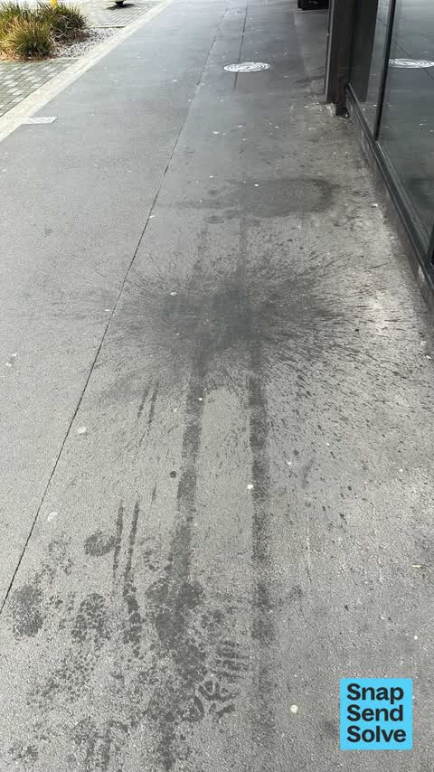
 Pavement - General —
 Vomit stains on pavement outside 79 Lichfield Street, since electric avenue
 Graffiti on a traffic light pole or cabinet, or wa —
 graffiti and posters on cabinet.
- Litter —
Broken glass/bottles across entire footpath for a few metres
 Graffiti on a fence, building or structure —
 Graffiti on abandoned building
 Poles and Signage - General —
 No left turn sign for entry into bus interchange out of alignment
 Graffiti somewhere else —
  Graffiti somewhere else —
  Animal - Deceased —
  Pavement - Damaged —
 Major sinking outside Lichfield Exit - Bus Interchange. Hundreds of buses drive over this every day - needs looking at urgently. Road cra
 Trees - General —
 Hey Team, the tree outside Pilgrim was hit by a truck a couple of years ago and has never been the same since. It would be wonderful if it c
 Road Signage —
 Sign pole has been turned round as the bolt is loose down the bottom which has caused the road signs to face the wrong way and drivers can n
 Graffiti —
 Toilet block in the bus exchange
- Graffiti —
- Graffiti —
- Graffiti —
- Graffiti —
 Pavement - Damaged —
 Grills need replacing . Trip hazard
 Public Toilet —
 Bus station. Unused toilet roll holder ? It’s covered in Dirt
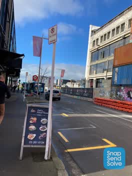 Roading/Streets —
 Taxi stand sign is facing towards footpath & needs to be turned around to face the street. Pole has been hit by vehicle & is bent & the bott
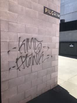 Graffiti —
 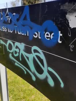 Graffiti —
 this is the third off it's not the first time I have recorded graffiti on this you have to do something about it put it up higher or have so
Roading/Streets —
conflicting sign when part of area is painted with byl.
Also reported on Lichfield Street
- 160 Lichfield Street — 37 reports
- 84 Lichfield Street — 27 reports
- 71 Lichfield Street — 25 reports
- 116 Lichfield Street — 22 reports
- 60 Lichfield Street — 19 reports
- 140 Lichfield Street — 19 reports
- 81 Lichfield Street — 18 reports
- 75 Lichfield Street — 18 reports
The street’s crash record
NZTA’s record names Lichfield Street in 71 crashes that hurt somebody since 2006 — 14 seriously hurt, nobody killed.
The green nearby
- Excelsior Hotel Reserve — 111 m to the edge · Botanic
- City Mall — 117 m to the edge
- High Street Triangles — 142 m to the edge
- The Stewart Plaza — 225 m to the edge
- Cathedral Square — 342 m to the edge · Botanic
Parks within half a kilometre, measured to the boundary — the council’s open data.
The civic shelf nearby
- Triangle — 192 m away · Car park
- Re:start - Lichfield St — 197 m away · Car park
- Turanga Library — 467 m away · Library · Cathedral Square, Christchurch
- St Asaph — 471 m away · Car park
Libraries, halls and the rest within half a kilometre — the council’s open data.
On the doorstep
- Pilgrim — 14 m away · Cafés
- Zak's Kebabs — 15 m away · Fast food
- Zak's Kebab House — 18 m away · Fast food
- ElectrifyNZ — 21 m away · Business
Businesses within four hundred metres, measured at the pin — OpenStreetMap and the council directories.
The bus nearby
- Bus Interchange (Platform D) — 40 m away · route 1, route 7, route 8, route 27, route 44, route 91, route 92, route 95
- Bus Interchange (Platform C) — 64 m away · route 3, route 5, route 29, route 60, route 80, route 81, route 84, route 85, route 86
The closest Metro stops, within four hundred and fifty metres.
The tracks through here
- Walk and bike track through Christchurch Central City — 99 m to the line · walk · bike
- Walk and bike track through Christchurch Central City — 120 m to the line · walk · bike
- Walk and bike track through Christchurch Central City — 250 m to the line · walk · bike
- Walk and bike track through Christchurch Central City — 379 m to the line · walk · bike
- Walk and bike track through Christchurch Central City — 389 m to the line · walk · bike
Tracks whose line passes within half a kilometre, measured to the line itself — the council’s open data.
The named ground
Named water within 500 m of this address, measured to the line or the edge; Named places within 1.5 km of this address; the council’s own structure register — bridges, boardwalks and steps standing nearby — the open map’s record.
The remembered names nearby
- Te Kiheru Wai o Tahu / the Canoe Bailer of Tahu / 2015 — 111 m away ·
Te Kiheru Wai o Tahu / The Canoe Bailer of Tahu / 2015 / (MÄori text and English translat
· 2015 - The First Public Water Supply Well Was Drilled Near This — 211 m away ·
THE FIRST PUBLIC WATER SUPPLY WELL was drilled near this site on 10 February 1864 by the C
· 2009 - ‘corgis on High’ — Christchurch City Public Artwork — 217 m away ·
‘Corgis on High’ — Christchurch City public artwork, 6 December 2003
· 2009
Inscribed plaques within two hundred and fifty metres — the register’s pins, not surveyed spots. The whole roll is at /plaques.
Renting nearby
new bonds in Christchurch Central City ran about $508 a week — $42 below the city median of $550 — the suburb page keeps the rent record →.
What was here — Commercial Building and Setting, Former Sargood Son and Ewen
37 m away · 92 Lichfield Street · located to ±28 m · the place’s own record →
On the register. Nothing researched here yet.
What was here — Commercial Building and Setting, Former Wellington Woollen Mills Manufacturing Company
50 m away · 96 Lichfield Street · located to ±28 m · the place’s own record →
On the register. Nothing researched here yet.
What was here — Commercial Building and Setting
51 m away · 225 High Street · located to ±19 m · the place’s own record →
On the register. Nothing researched here yet.
What was here — Triangle Reserve and Setting
86 m away · 192F High Street · located to ±17 m · the place’s own record →
On the register. Nothing researched here yet.
What was here — Triangle Reserve and Setting
102 m away · 220F High Street · located to ±17 m · the place’s own record →
On the register. Nothing researched here yet.
The civic layer
This ground votes in Central ward — the Papanui-Innes-Central community board. Ward lines don’t always follow suburb lines; this one is measured at the pin, not the suburb’s centre.
What stood on this ground → · On the map → · From the air — the Crown’s aerials back to 1936; search the address on RetroLens →
Questions, answered briefly
25 council reports on record since February 2017 — most often graffiti (7), roading/streets (2), road signage (2).
Christchurch Central City, Christchurch — on Lichfield Street.
The heritage register names 5 places at or beside it — Commercial Building and Setting, Former Sargood Son and Ewen, Commercial Building and Setting, Former Wellington Woollen Mills Manufacturing Company.
Excelsior Hotel Reserve — 111 m to its edge.