71 Lichfield Street, Christchurch Central City
25 reports on record since August 2018 · 20 with photographs. The street’s heaviest record is 160 Lichfield Street — 37 reports on file. Indicative rating valuation and school zones, hazards, bin day and what stood here before.
What gets reported here
Photographed here 20 on record


Reported here
 Roads - General —
Please put a zebra crossing here. People walking should be prioritised next to the public transport hub of the city
 Graffiti on a fence, building or structure —
 Graffiti on a fence, building or structure —
Graffiti on wall
 Graffiti on a fence, building or structure —
Red paint tag on large rubbish bin by 71 Lichfield Street.
 Graffiti on a bus stop or public toilet —
 Litter —
Litter yet again and graffiti Why do you not clean this street like all the others
 Hazard — vehicle —
Parked in bus stop
 Vandalism - General —
 Pavement - General —
Footpath covered in pigeon mess. Can this be cleaned please?
 Graffiti —
Purple paint tag on bus stop seat at 71 Lichfield Street.
 Litter —
Lots of litter on street. Have picked up some. Guy vomiting on street and against bus interchange wall
 Graffiti —
 Litter —
Outside bus interchange Lichfield st. As usual there is rubbish everywhere. This area never gets cleaned or swept. Not once in 7 months have
- Litter —
- Graffiti —
- Graffiti —
- Graffiti —
- Graffiti —
 Rubbish and Bins - General —
Rubbish bin needs to be cleared
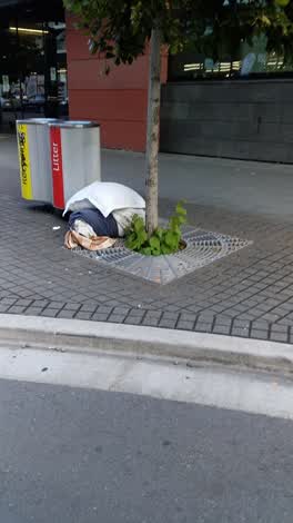 Rubbish/Recycling —
outside bus Lichfield st
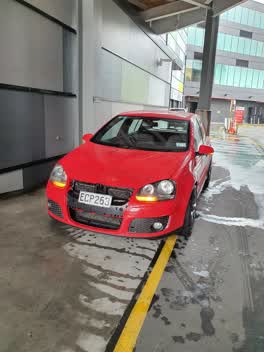 Roading/Streets —
From 4.16pm to 4.31pm 28/12/21, this car was parked in a Restricted Park (limited to FreshChoice City Market Staff). Occupants were not em
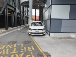 Roading/Streets —
Illegally Parked on private property. Over the yellow line in a No Parking Lane / Loading Zone
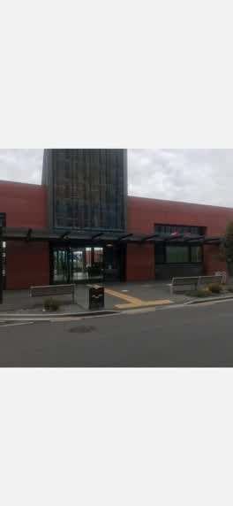 Roading/Streets —
I m one of the council tenants located inside the Bus Interchange. I don't know if this is the right area to report this. But This is only
Roading/Streets —
There is a major section of missing footpath at the entrance to the crossing carpark. This creates a major issue with effectively an uncont
Roading/Streets —
Front of the entrance on Bus Interchange via Lichfield Street.Cabage trees vandalized.
Also reported on Lichfield Street
- 160 Lichfield Street — 37 reports
- 84 Lichfield Street — 27 reports
- 90 Lichfield Street — 25 reports
- 116 Lichfield Street — 22 reports
- 60 Lichfield Street — 19 reports
- 140 Lichfield Street — 19 reports
- 81 Lichfield Street — 18 reports
- 75 Lichfield Street — 18 reports
The street’s crash record
NZTA’s record names Lichfield Street in 71 crashes that hurt somebody since 2006 — 14 seriously hurt, nobody killed.
The green nearby
- City Mall — 100 m to the edge
- High Street Triangles — 120 m to the edge
- Excelsior Hotel Reserve — 185 m to the edge · Botanic
- The Stewart Plaza — 187 m to the edge
- Cathedral Square — 310 m to the edge · Botanic
Parks within half a kilometre, measured to the boundary — the council’s open data.
The civic shelf nearby
- Re:start - Lichfield St — 138 m away · Car park
- Triangle — 151 m away · Car park
- Turanga Library — 444 m away · Library · Cathedral Square, Christchurch
Libraries, halls and the rest within half a kilometre — the council’s open data.
On the doorstep
- Espresso Car Wash — 4 m away · Business
- Flight Centre — 6 m away · Business
- Fresh Choice City Market — 6 m away · Supermarkets
- Lil’ Ruby — 11 m away · Cafés
Businesses within four hundred metres, measured at the pin — OpenStreetMap and the council directories.
The bus nearby
- Bus Interchange (Intercity stop) — 39 m away · route 3, route 8, route 80
- Bus Interchange (Platform C) — 41 m away · route 3, route 5, route 29, route 60, route 80, route 81, route 84, route 85, route 86
The closest Metro stops, within four hundred and fifty metres.
The tracks through here
- Walk and bike track through Christchurch Central City — 133 m to the line · walk · bike
- Walk and bike track through Christchurch Central City — 172 m to the line · walk · bike
- Walk and bike track through Christchurch Central City — 315 m to the line · walk · bike
- Walk and bike track through Christchurch Central City — 317 m to the line · walk · bike
- Walk and bike track through Christchurch Central City — 322 m to the line · walk · bike
Tracks whose line passes within half a kilometre, measured to the line itself — the council’s open data.
The named ground
Named water within 500 m of this address, measured to the line or the edge; Named places within 1.5 km of this address; the council’s own structure register — bridges, boardwalks and steps standing nearby — the open map’s record.
The remembered names nearby
- Te Kiheru Wai o Tahu / the Canoe Bailer of Tahu / 2015 — 126 m away ·
Te Kiheru Wai o Tahu / The Canoe Bailer of Tahu / 2015 / (MÄori text and English translat
· 2015
Inscribed plaques within two hundred and fifty metres — the register’s pins, not surveyed spots. The whole roll is at /plaques.
Renting nearby
new bonds in Christchurch Central City ran about $508 a week — $42 below the city median of $550 — the suburb page keeps the rent record →.
What was here — Former Beaths Department Store (components)
101 m away · 201/690 Colombo Street · located to ±21 m · the place’s own record →
On the register. Nothing researched here yet.
What was here — Commercial Building and Setting, Former Sargood Son and Ewen
103 m away · 92 Lichfield Street · located to ±28 m · the place’s own record →
On the register. Nothing researched here yet.
What was here — Commercial Building and Setting
113 m away · 225 High Street · located to ±19 m · the place’s own record →
On the register. Nothing researched here yet.
What was here — Commercial Building and Setting, Former Wellington Woollen Mills Manufacturing Company
121 m away · 96 Lichfield Street · located to ±28 m · the place’s own record →
On the register. Nothing researched here yet.
What was here — Triangle Reserve and Setting
124 m away · 220F High Street · located to ±17 m · the place’s own record →
On the register. Nothing researched here yet.
The civic layer
This ground votes in Central ward — the Papanui-Innes-Central community board. Ward lines don’t always follow suburb lines; this one is measured at the pin, not the suburb’s centre.
What stood on this ground → · On the map → · From the air — the Crown’s aerials back to 1936; search the address on RetroLens →
Questions, answered briefly
25 council reports on record since August 2018 — most often graffiti (6), roading/streets (5), litter (4).
Christchurch Central City, Christchurch — on Lichfield Street.
The heritage register names 5 places at or beside it — Former Beaths Department Store (components), Commercial Building and Setting, Former Sargood Son and Ewen.
City Mall — 100 m to its edge.