Park - General RequestCanterbury
A large tree has come down in the domain, breaking the fence and stye.
41 council reports since November 2017, the 106th busiest suburb in the city. 25 photographs on record.
The record also holds 2023 Census snapshot· 25 photographs· 2 old photographs· 2 parks· 2 civic facilities· 1 place of worship· 14 names on the map· the record drew water over 10% of the outline· inside the broad slope-instability overlay· the Ngāi Tahu schedule covers 1% of the outline· ecological sites over 1% of the outline· landscape schedules over 84% of the outline· setback strips over 6% of the outline· 5 SCIRT photographs filed on this ground· 2 remembered names on this ground· 6 drawn rules bind this ground· 1 parcels of made ground· 1 council structure on the register· 4 recreation register records· 41 trees on the register· the plan’s word on this ground· 1 place on the heritage schedule· 1 injury crashes· 2 recorded victimisations· the council’s fix times· 40 documents· 4 mentions on the wire
Link-outs to the source’s own live pages, chch.live does not copy their live values or source text.
The ground: the flood record drew water over 10% of it, the rest of the watch is drawn further down.
Day to day it holds 2 parks, 2 civic facilities and 1 place of worship, each is counted further down.
Lately the record’s mostly trees & parks, 8 reports in the year to 12 October 2026, the newest 10 June 2026.
One for the quiz, Le Bons Bay enters the written record on 22 August 1857, “Page 5 Advertisements Column 2 (Lyttelton Times, 22 August 1857)”, Papers Past.
About 651 people and 276 occupied private households in the “Banks Peninsula Eastern Bays” and “Diamond Harbour” areas, grouped from 6 SA1 areas. A wider statistical area stands in for this suburb, so this is a proxy rather than a count for the suburb boundary.
Ethnicity is a multiple-response measure, so those percentages are not meant to add to 100%.
Stats NZ’s 2023 Census uses fixed random rounding to base 3. Unavailable or confidential cells are left out, not treated as zero. individuals · households · geography · CC BY 4.0.
Placed by the record’s locality join or the name in its own title, a lead, not a claim each frame stood here.
A large tree has come down in the domain, breaking the fence and stye.


location is a guess, as no reception on summit road in between lebons bay and okains Bay summit road. water damage on side of road, taken away roadng and…
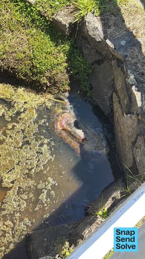
Something is dead in the water way in Rue De la Mer in Le Bons bay. It is decaying and smells putrid.

Dog control/vehicle on beach: today at 2.30pm FSN206 white truck drove on to beach then let brown labrador run with vehicle to river mouth and back and then…
Neighbours are singing outside with loud music. Becoming a regular weekend occurrence around holiday periods

Red light shows spasmodic indicating over load water level. Can hear pump going. Light eventually goes out. Suspect blockage at disposal field which has to my…
The septic tank at le bons public toilet is showing a red light, which indicates there is an issue in the system. It may be full and need emptying, or it might…


Tree Lucerne overhanging onto the road making it tight for traffic to pass
The median council work order pinned in Le Bons Bay took 4 weeks to resolve, the city-wide median is 3 days, so this ground runs slower than the city as a whole. The slowest tenth waited 4 months or longer. 9 tickets are open here now, the oldest was filed 18 July 2023.
Work orders, not the resident reports above, the council’s MyCouncilTicket stream, and one job can appear in both. A median counts only finished jobs; open ones are named as open, never averaged in. The ticket roll · the whole city’s fix times.
Zoned for Aidanfield Christian School · Christchurch Adventist School · Middleton Grange School · St Thomas of Canterbury College · Villa Maria College · Duvauchelle School (part), the drawn zone is indicative; the Ministry’s written scheme is the legal boundary.
Parks and reserves in the council’s open data, a park lands in the suburb its centre falls inside. The whole roll is at /parks.
Libraries, halls, cemeteries and the rest in the council’s open data, a facility lands in the suburb its point or centre falls inside. The whole shelf is at /facilities.
Places of worship in the open map’s record, one lands in the suburb its building stands in. The whole roll is at /worship.
The flood record drew water over 10.1% of this outline, about 674 hectares, across 1 named event. A patch is one event’s observation, not a live hazard finding; the whole record is drawn at /floods.
No named slope-hazard band reaches this outline. The broad remaining-instability overlay covers 82% of it besides, the plan’s background watch over the hill country. Shares read from a sampled join; a management overlay, not a prediction. The whole watch is drawn at /slope.
The files record 1 parcel of made or characterised ground inside this outline. A record is the file’s word on what was laid, not a fresh survey; the whole layer is drawn at /fill.
The council’s structure register stands 1 asset on this ground, 1 shelter, sited at Le Bons Bay Cemetery. The register’s site names are its own labels for the ground an asset stands in; the layer is drawn at the map.
The recreation register keeps 4 records inside this outline, bookable surfaces for 2 tennis, 1 cricket, 1 basketball. Seasons and surfaces are the register’s record, not this week’s draw; the layer is drawn at the map.
The register counts 41 living trees inside this outline, 13 veterans among them, 5 carrying a protection, mostly English Oak, Austrian Pine, Podaocarp. The file remembers 4 trees felled here. A tree record is the register’s word on what stands or stood; the whole canopy is drawn at /trees.
The plan files 80% of this outline under Rural Banks Peninsula, the rest mostly Open Space Natural 5%, 84% of the outline fell inside a mapped zone. A zone is a permission, not a description, the mix is read from a sampled join of the plan’s polygons; the whole district is drawn at /zones.
The plan’s heritage schedule protects 1 place by name in this suburb, Peace Memorial Library and Setting. A setting is the ground the item stands in, each files under the suburb holding its centroid; the whole schedule is at /heritage.
The plan’s schedule of sites significant to Ngāi Tahu covers 1% of this outline, about 39 hectares, ngā wai. Shares read from a sampled join; a recognition overlay, not a catalogue. The whole schedule is drawn at /cultural.
The plan’s ecological schedules cover 1% of this outline, about 77 hectares across 2 scheduled sites, 1% of it Schedule B, identified on private land but not yet protected. Shares read from a sampled join; a recognition overlay, not a survey. The whole ledger is drawn at /ecology.
The plan’s landscape schedules cover 84% of this outline, about 5,616 hectares across 18 scheduled areas, 25% of it outstanding, the plan’s strongest landscape standing, and 13% of it sits inside the coastal environment. 3 main ridgelines run through, the skyline itself is protected. Shares read from a sampled join; a protection overlay, not a ranking of views. The kept view is drawn at /landscape.
The plan’s water-margin layers cross this outline, 175 classified reaches, the plan calling Le Bons Stream and Hughes Drain by name, 6% of it inside the setback strips, the widest holding 20 m off the bank. The margin is the plan’s drawing, not a survey of the bank; the reaches, strips and held edges are mapped at /water-margin.
The plan’s allowed shape holds this outline, 1 hill density line holds the high ground low. The shape is the plan’s permission, not a survey of what stands; the allowed shape is drawn at /density.
The rebuild’s cameras filed 5 photographs on this ground, stormwater work mostly. Each frame is a receipt the dig left behind, a work log, not a survey of what stands now; the whole record is drawn at /rebuild.
The remembered names stand on this ground, 2 inscribed plaques, Le Bons Bay Cemetery, Le Bons Bay Domain among the grounds. The plaque is the register’s pin, not a surveyed spot; the whole roll is kept at /plaques.
The rulebook binds this ground, 6 drawn instruments, 6 of them dog rules; the outline sits inside the takiwā of Te Runanga o Koukourarata and Te Runanga o Onuku. The bylaw is the instrument, this the map of it, the whole rulebook is drawn at /rules.
The named waterways, bays, headlands, monuments, summits and old sites OpenStreetMap puts inside this outline, a pin is the mapper’s own; a waterway belongs to every suburb it crosses. Every roll, counted: /geography.
1 crash that hurt somebody on record inside Le Bons Bay's outline, 0 seriously hurt, nobody killed.
The corner that keeps appearing: Le Bons Bay Road at Panama Road, 1 injury crash.
2 victimisations on the Police record inside Le Bons Bay’s outline, September 2022–August 2026, mostly burglary, about 1 a year per 1,000 residents. Reported is not all, how much never reaches the record depends on the offence.
What the archive’s sources say about Le Bons Bay, titled for it, turned up by a search for one of its places, or carrying its name in the text. These are leads and citations: the originals live at the provider, linked from each row.
…christchurch m j burke timaru beechey ghristchurch bilton christchurch carew akaroa cuff le bons bay coxhead christchurch campion timaru joshua cuff akaroa g dunnage purarikanui dorsett christchurch…Lyttelton Times · Papers Past · National Library of New Zealand · · text held
…eechey christchurch bilton christchurch a f n blakiston ferry ka carew akaroa 7 koad cuff le bons bay coxhead christehurch campion timaru joshua cuff akaroa g dunnage purarikanui dorsett christehurch…Lyttelton Times · Papers Past · National Library of New Zealand · · text held
…arket dray ton richmond chandler salford barrett exall andrews reading w williams bedford le bons bay to be sold3o acres bush situated in the above bay adjoining 1 cuff mill for particulars apply to j…Lyttelton Times · Papers Past · National Library of New Zealand · · text held
…period for which they would be held on terms apply to mr ollivier cashel and high streets le bons bay to be sold3o acres bush situated in the above bay adjoining cuff mill for particulars apply to j a…Lyttelton Times · Papers Past · National Library of New Zealand · · text held
…peter fox 55 bs duvauchelle bay lyell akaroa and okatite bay j b parker 60 german bay and le bons bay a 0 condon 30 i waiau and hanmerplaim thomas fraser 70 christchnrch and akaroa via halswell tai ta…Timaru Herald · Papers Past · National Library of New Zealand · · text held
…ldine 260 acee fenced good house temuka 500 aores banks peninsula 1803 acres pastoral 219 le bons bay 1000 aero aehley 400 aores 2 10s per acre 227-hieds 1880 acres 238 little river 722 acres good hou…Star · Papers Past · National Library of New Zealand · · text held
The rest are a search away, the whole shelf, for the name →
Compare Le Bons Bay with Okains Bay · Akaroa · Duvauchelle · Wainui · Pigeon Bay · Little River, same record, side by side.
A suburb of Christchurch, New Zealand, the public record holds 41 council reports for it, the first filed in November 2017.
About 651 people and 276 occupied private households (wider SA2 stand-in): grouped from Stats NZ SA1 areas through this site’s suburb join. Indicative, not a LIM.
41 reports on record, most often trees & parks (17), water & drains (7), roads & footpaths (6). 8 of them in the year to 12 October 2026.
1 injury crash on the police record inside the suburb’s outline, 0 seriously hurt, nobody killed. The suburb’s crashes, mapped →
Every suburb in Christchurch → · Its decade, charted → · the whole A–Z →
Work orders, not the resident reports above, the council’s MyCouncilTicket stream, and one job can appear in both. A median counts only finished jobs; open ones are named as open, never averaged in. The ticket roll · the whole city’s fix times.
The council’s bylaw zones and the Local Alcohol Policy’s buffer list, read from the Regulatory open-data service. A ban rules drinking in public places; it says nothing about whether a premises may sell, that is the licence register’s job.
Ministry of Education directory, the final decile and the current Equity Index describe the community a school draws from, not how well it teaches. Zones are indicative; the written enrolment scheme rules.
Parks and reserves in the council’s open data, the park lands in the suburb its centre falls inside; one that straddles the line keeps its own address.
Libraries, halls, cemeteries and the rest in the council’s open data, a facility lands in the suburb its point or centre falls inside.
Places of worship in the open map’s record, one lands in the suburb its building stands in. The whole roll is at /worship.
Marae in the region’s roll, a marae stands where it stands; the join names the suburb the roll files it under. The whole roll is at /maraes.
Walking, biking, horse and off-road tracks in the council’s open data, a line belongs to every suburb it passes through.
OpenStreetMap’s own record, inside this outline, a pin is the mapper’s; a waterway belongs to every suburb it crosses. Every roll, counted: /geography.
Heritage places the council’s district plan or Heritage New Zealand list inside this suburb, each with what is known about it and the document it is known from.
The register’s era records for places in this suburb, what stood on the ground, and when.
Each of these is a decade of reports, the heritage places on the register, what is known about them, and the documents behind it, everything the archive holds about the part of the city it names.