
Cass Bay, Christchurch
538 council reports since June 2015, the 86th busiest suburb in the city. 429 photographs on record.
The record also holds about $600 a week to rent· 2023 Census snapshot· 429 photographs· 2 old photographs· 5 parks· 3 names on the map· the mapped tsunami reach covers 1% of the outline· slope-hazard bands cover 21% of the outline· the Ngāi Tahu schedule covers 17% of the outline· landscape schedules over 90% of the outline· setback strips over 10% of the outline· 122 SCIRT photographs filed on this ground· 0.1 km of cycleway crosses the outline· 8 drawn rules bind this ground· 1 parcels on the dangerous-work register· 5 parcels of made ground· 762 surveyed rocks· 1 parcels with a cleanup on file· the 2019 model grades this ground mostly unlikely· 21 council structures on the register· 17 trees on the register· the plan’s word on this ground· 11 epicentres inside the outline· 16 injury crashes· 4 recorded victimisations· 2 bus stops· 1 business· the council’s fix times· 40 documents
Live source links
Link-outs to the source’s own live pages, chch.live does not copy their live values or source text.
Living here rent · the ground · the day-to-day
$600/week
middle half $473–$640
New bonds here ran at about $600 a week in the April–June 2026 quarter, the middle half of them between $473 and $640, across 24 bonds lodged, up 9% on a year ago. That’s about $50 a week above the city’s own quarter median of $550. Tenancy Services counts these under the Lyttelton area, which takes in this coast with its neighbours.
By dwelling type and bedrooms, April–June 2026 quarter
- 1-bedroom house, $630 a week · 9 new bonds
Median and quartiles of weekly rents on new private bonds, by quarter. New bonds are fresh lodgements, not the whole rental stock; under five bonds the rent is withheld, and counts are randomly rounded. Source: Tenancy Services rental bond data: provisional while the bond system migrates.
The ground: the mapped tsunami reach covers 1% of it, the rest of the watch is drawn further down.
Day to day it holds 5 parks and 2 bus stops, each is counted further down.
Lately the record’s mostly water & drains, 73 reports in the year to 12 October 2026, the newest 11 October 2026.
One for the quiz, Its busiest day on record was 16 January 2022, 8 reports in a single day.
2023 Census snapshot SA1 areas grouped here
About 3,117 people and 1,353 occupied private households in the “Lyttelton” statistical area, grouped from 19 SA1 areas. Nearby statistical areas stand in for this place, so this is a proxy rather than a count for the suburb boundary.
More of the 2023 Census
- Born overseas27% of stated birthplace
- European ethnicity92% of ethnicity responses
- Māori ethnicity12% of ethnicity responses
- Pacific Peoples ethnicity2% of ethnicity responses
- Asian ethnicity3% of ethnicity responses
- Households with internet86% of stated households
- Households with two or more vehicles56% of stated households
Ethnicity is a multiple-response measure, so those percentages are not meant to add to 100%.
Stats NZ’s 2023 Census uses fixed random rounding to base 3. Unavailable or confidential cells are left out, not treated as zero. individuals · households · geography · CC BY 4.0.
As reported 429 on record
The suburb, back then 2 in the archive
Placed by the record’s locality join or the name in its own title, a lead, not a claim each frame stood here.
The shape of it outline © OpenStreetMap · recent reports, pinned
The record on Cass Bay
- Cass Bay enters the written record on 17 April 1852, “Page 1 Advertisements Column 3 (Lyttelton Times, 17 April 1852)”, Papers Past.
- “Cass Bay” appears somewhere in 43 of the archive’s records, title, description or body.
- A Papers Past search for the name surfaced 31 records, leads by provenance, not by phrase.
- The first report the feed ever carried here: water supply, 9 June 2015, at 48 Bayview Pl.
- Its busiest day on record was 16 January 2022, 8 reports in a single day.
- The street that keeps coming up is Bayview Place, reported on 110 separate days.
- For elections the suburb’s centre falls inside Banks Peninsula ward, the Banks Peninsula community board is its local layer. The whole roll is at /wards.
Lately the newest reports

Playground Equipment50 Bayview Pl
It looks like the weekenders today were a bit too much for the New playground. Recommending securing the connection to a top bolt with a washer rather than…

Sewer - Leak / Blockage4 Cass Bay Place
the reserve between 4 and 6 cass bay place. at bottom of stairs bad sewer leak

Playground Equipment50 Bayview Pl
Playground bird stolen, community reported to police as they have cctv footage. Sending a report to capture theft in data.


Park - General Request50 Bayview Pl
Water from dog bowl causing a very wet patch on lawn. Also will be an issue in heavy rain as this is a low point. Needs a slot drain installed
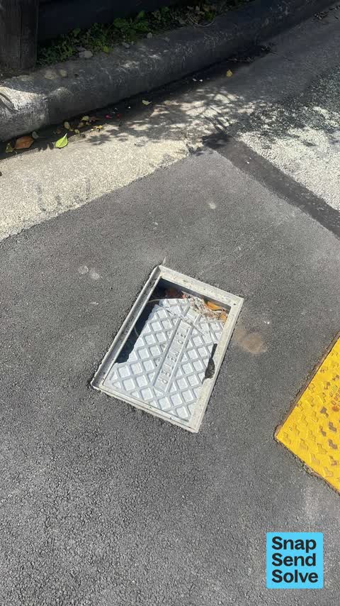
Roads - General8 Kaikomako Pl
I have reported this before and it has not been Fixed. This morning a young child was riding his bike and went over this and fell off - he’s ok. It scraped his…

Graffiti on a playground or in a park64 Governors Bay Rd
The graffiti on the steadfast park is on one of the newly refurbished buildings new roof and new cladding it’s not derelict it’s New the police were called out…

Facility - General Request31 Harbour View Terrace
Man with a tent has pitched up Saturday 12th September. he is talking to himself, approaching the public and just hassled a lady with her dog. concerned for…
Reports per year up 11% 2024→2025
15
3
16
3
17
9
18
19
19
21
20
35
21
58
22
69
23
87
24
87
25
97
What gets reported
Exactly what people say
How fast the council fixes things here 930 finished jobs on record
The median council work order pinned in Cass Bay took 7 days to resolve, the city-wide median is 3 days, so this ground runs slower than the city as a whole. The slowest tenth waited 4 months or longer. 23 tickets are open here now, the oldest was filed 16 March 2019.
Work orders, not the resident reports above, the council’s MyCouncilTicket stream, and one job can appear in both. A median counts only finished jobs; open ones are named as open, never averaged in. The ticket roll · the whole city’s fix times.
The suburb today
Schools here
Zoned for Christchurch Adventist School · Hillview Christian School · Lyttelton Primary School · Marian College · Middleton Grange School · St Anne's School (Woolston) · and 4 more zones, the drawn zone is indicative; the Ministry’s written scheme is the legal boundary.
The green here 5
- Hmnzs SteadfastRegional · 23 ha
- Pony PointRegional · 7 ha
- Cass Bay Playgroundplayground, 22 pieces
- Cass Bay Walkway
- Police Reserve
Parks and reserves in the council’s open data, a park lands in the suburb its centre falls inside. The whole roll is at /parks.
The names on this ground 3
The mapped tsunami extent covers 1% of this outline. The sea’s modelled reach, not a prediction, the plan’s inundation line, not the evacuation zones; the share is read from a sampled join. The whole extent is drawn at /tsunami.
The plan’s slope-hazard bands cover 21% of this outline, about 56 hectares, rockfall management area 1, rockfall management area 2. The broad remaining-instability overlay covers 79% of it besides, the plan’s background watch over the hill country. Shares read from a sampled join; a management overlay, not a prediction. The whole watch is drawn at /slope.
1 parcel inside this outline sits on the hazardous-activities register, mostly chemical manufacture, application and bulk storage. A listing records the work, not a soil test; the whole register is drawn at /hazards.
The files record 5 parcels of made or characterised ground inside this outline, mostly loess, sand. A record is the file’s word on what was laid, not a fresh survey; the whole layer is drawn at /fill.
The rockfall survey mapped 762 rocks inside this outline across 234 survey pins, 419 came down, 71 still wobble easy. A pin may stand for a cluster and marks where the survey saw the rock, not where it is now; the whole survey is drawn at /boulders.
1 parcel inside this outline carries a cleanup on the file. A cleanup on the file is the register’s word, not a clearance; the whole register is drawn at /remediated.
The 2019 liquefaction study put 2% of this outline in the "unlikely" class, 2% of the outline fell inside an assessed area. A class is the model’s verdict on a patch of ground, not a finding about an address; the whole study is drawn at /vulnerability.
The council’s structure register stands 21 assets on this ground, 9 sets of steps, 5 bridges, 3 shelters, 2 boat ramps, sited at Pony Point, Corsair Bay Reserve, Hmnzs Steadfast, Cass Bay Walkway. The register’s site names are its own labels for the ground an asset stands in; the layer is drawn at the map.
The register counts 17 living trees inside this outline, mostly Cherry, Flowering Cherry, Macrocarpa. The file remembers 16 trees felled here. A tree record is the register’s word on what stands or stood; the whole canopy is drawn at /trees.
The plan files 52% of this outline under Rural Banks Peninsula, 7% residential, the rest mostly Open Space Natural 32%, Residential Banks Peninsula 7%. A zone is a permission, not a description, the mix is read from a sampled join of the plan’s polygons; the whole district is drawn at /zones.
The plan’s schedule of sites significant to Ngāi Tahu covers 17% of this outline, about 45 hectares, ngā tūranga tūpuna, wāhi tapu/wāhi taonga. A silent-file precinct covers 56% of it besides, sensitive ground the plan flags without naming the sites. Shares read from a sampled join; a recognition overlay, not a catalogue. The whole schedule is drawn at /cultural.
The plan’s landscape schedules cover 90% of this outline, about 242 hectares across 6 scheduled areas, 60% of it outstanding, the plan’s strongest landscape standing, and 4% of it sits inside the coastal environment. 1 main ridgeline runs through, the skyline itself is protected. Shares read from a sampled join; a protection overlay, not a ranking of views. The kept view is drawn at /landscape.
The plan’s water-margin layers cross this outline, 12 classified reaches, 10% of it inside the setback strips, the widest holding 20 m off the bank. The margin is the plan’s drawing, not a survey of the bank; the reaches, strips and held edges are mapped at /water-margin.
The plan’s allowed shape holds this outline, 1 hill density line holds the high ground low. The shape is the plan’s permission, not a survey of what stands; the allowed shape is drawn at /density.
The rebuild’s cameras filed 122 photographs on this ground, 2011–2014, stormwater work mostly. Each frame is a receipt the dig left behind, a work log, not a survey of what stands now; the whole record is drawn at /rebuild.
The pedal network threads this ground, 0.1 km of cycleway crosses the outline. A segment counts under every suburb its path enters; the whole network is drawn at /cycleways.
The rulebook binds this ground, 8 drawn instruments, 7 of them dog rules, 1 camping zone, Rāpaki Prohibited Area bans camping outright; the outline sits inside the takiwā of Rapaki Runanga and Te Ngai Tuahuriri Runanga. The bylaw is the instrument, this the map of it, the whole rulebook is drawn at /rules.
GeoNet’s catalogue puts 11 magnitude-3+ epicentres inside this outline since the sequence opened, the biggest a M4.2 in 2011. An epicentre is where the instruments placed the break, not a measure of the shaking here; the whole catalogue is counted at /sequence, the live record is /quakes, and the story in plain language is the earthquakes explainer.
- Cass Baybeach
- Ōtūherekioheadland
- Watchtower lookoutlookout
The named waterways, bays, headlands, monuments, summits and old sites OpenStreetMap puts inside this outline, a pin is the mapper’s own; a waterway belongs to every suburb it crosses. Every roll, counted: /geography.
The crash record 16 injury crashes
16 crashes that hurt somebody on record inside Cass Bay's outline, 2 seriously hurt, nobody killed.
The corner that keeps appearing: Governors Bay Road at Mariners Cove, 7 injury crashes.
The crime record 4 recorded victimisations
4 victimisations on the Police record inside Cass Bay’s outline, September 2022–August 2026, mostly burglary, about 0 a year per 1,000 residents. Reported is not all, how much never reaches the record depends on the offence.
The buses through it 2 stops
2 Metro stops inside Cass Bay's outline, in ECan’s stop record, served by route 8.
- Governors Bay Rd
- Governors Bay Rd near Mariners Cv
Businesses here 1 in the directory
1 premises in Cass Bay across 1 kind, from OpenStreetMap, the council’s licensed-premises register and its 2024 Find Christchurch directory. Each kind below opens at this suburb’s shelf.
Before any of that
Documents 40
What the archive’s sources say about Cass Bay, titled for it, turned up by a search for one of its places, or carrying its name in the text. These are leads and citations: the originals live at the provider, linked from each row.
261850s
41860s
1870s
51900s
151910s
21920s
32000s
32010s
Page 1 Advertisements Column 3 (Lyttelton Times, 17 April 1852)
…eehold land on the heathcote with va mile river frontage and 50 acres of freehold land in cass bay with or without 500 acres of pasturage adjoining the section on the heathcote may be had in lots of 5…Lyttelton Times · Papers Past · National Library of New Zealand · · text held
Page 4 Advertisements Column 1 (Lyttelton Times, 24 April 1852)
…reehold land on the heathcote with 1 mile river frontage and 50 acres of freehold land in cass bay with or without 500 acres of pasturage adjoining the section on the heathcote may be had in lots of 5…Lyttelton Times · Papers Past · National Library of New Zealand · · text held
Page 11 Advertisements Column 3 (Lyttelton Times, 01 May 1852)
…freehold land on the heathcote with mile river frontage and 50 acres of freehold land in cass bay with or without 500 acres of pasturage adjoining the section on the heathcote maybe had in lots of 5…Lyttelton Times · Papers Past · National Library of New Zealand · · text held
Page 2 Advertisements Column 2 (Lyttelton Times, 09 October 1852)
…lot of cattle are some of the best ever introduced into the colony and are to be seen at cass bay apply to mr james weight london street lyttelton robin hood hotel lyttelton to be sold by private tre…Lyttelton Times · Papers Past · National Library of New Zealand · · text held
Page 3 Advertisements Column 3 (Lyttelton Times, 11 December 1852)
…lot of cattle are some of tbe best ever introduced into the colony and are to be seen at cass bay apply to mr james wright london street lyttelton rams for sale por sale 3 first-rate rams now running…Lyttelton Times · Papers Past · National Library of New Zealand · · text held
Page 11 Advertisements Column 1 (Lyttelton Times, 04 June 1853)
…the lyttelton times shall receive the above reward two pounds reward lost from the run of cass bay a red heifer branded with s on the near rump supposed to have a calf with her whosoever will give inf…Lyttelton Times · Papers Past · National Library of New Zealand · · text held
Page 12 Advertisements Column 1 (Lyttelton Times, 11 June 1853)
…he lyttelton times shall receive the above reward two pounds reward t ost from the run of cass bay a a red heifer branded with s on the near rump supposed to have a calf with her whosoever will give i…Lyttelton Times · Papers Past · National Library of New Zealand · · text held
Page 2 Advertisements Column 1 (Lyttelton Times, 09 July 1853)
…ch the above reward will be given 28th june 1853 two pounds reward x lost from the bun of cass bay a red heifer branded with s on the near rump supposed to hare a calf with her whosoever will give inf…Lyttelton Times · Papers Past · National Library of New Zealand · · text held
ELECTORAL ROLL FOR THE DISTRICT OF CHRISTCHURCH, July 5th, 1853. (Lyttelton Times, 16 July 1853)
…on head on part of mr bray land freehold 100 acres on the river heathcote and 50 acres in cass bay a householder having resided 6 calandar months in a tenement avithout the limits of a town of the cle…Lyttelton Times · Papers Past · National Library of New Zealand · · text held
Page 11 Advertisements Column 1 (Lyttelton Times, 06 August 1853)
…ll receive the above reward christchorch aug 3rd i two pounds reward lost from the run of cass bay a red heifer branded with s on the near rump supposed to have a calf with her whosoever will give inf…Lyttelton Times · Papers Past · National Library of New Zealand · · text held
The rest are a search away, the whole shelf, for the name →
Next door
Compare Cass Bay with Corsair Bay · Lyttelton · Rapaki · Heathcote Valley · Te Rapaki o Te Rakiwhakaputa · Diamond Harbour, same record, side by side.
Questions, answered briefly
What is Cass Bay?
A suburb of Christchurch, New Zealand, the public record holds 538 council reports for it, the first filed in June 2015.
How many people does the 2023 Census count for Cass Bay?
About 3,117 people and 1,353 occupied private households (nearby SA1s): grouped from Stats NZ SA1 areas through this site’s suburb join. Indicative, not a LIM.
What gets reported in Cass Bay?
538 reports on record, most often water & drains (159), trees & parks (154), graffiti & vandalism (84). 73 of them in the year to 12 October 2026.
How many crashes has Cass Bay had?
16 injury crashes on the police record inside the suburb’s outline, 2 seriously hurt, nobody killed. The suburb’s crashes, mapped →
Did earthquakes strike under Cass Bay?
GeoNet’s catalogue puts 11 magnitude-3+ epicentres inside the suburb’s mapped outline since the September 2010 mainshock, the biggest a M4.2 in 2011. An epicentre is where the instruments placed the break, not a measure of the shaking felt here. The whole sequence, counted → · The story, in plain language →
Does Cass Bay have buses?
2 Metro stops inside the suburb’s outline, served by 8.
Every suburb in Christchurch → · Its decade, charted → · the whole A–Z →