
Scarborough, Christchurch
780 council reports since June 2015, the 82nd busiest suburb in the city. 620 photographs on record.
The record also holds about $620 a week to rent· 2023 Census snapshot· 620 photographs· 7 old photographs· 4 parks· 5 names on the map· 4.7% of the outline in the red zone· the mapped tsunami reach covers 1% of the outline· slope-hazard bands cover 9% of the outline· the Ngāi Tahu schedule covers 100% of the outline· landscape schedules over 19% of the outline· setback strips over 5% of the outline· 132 SCIRT photographs filed on this ground· 1.9 km of cycleway crosses the outline· 13 remembered names on this ground· 10 drawn rules bind this ground· 23 parcels of made ground· 457 surveyed rocks· the 2019 model grades this ground mostly unlikely· 39 council structures on the register· 280 trees on the register· the plan’s word on this ground· 5 epicentres inside the outline· 3 injury crashes· 114 recorded victimisations· 2 businesses· the council’s fix times· 1 heritage place· 40 documents· 4 mentions on the wire
Live source links
Link-outs to the source’s own live pages, chch.live does not copy their live values or source text.
Living here rent · the ground · the day-to-day
$620/week
middle half $500–$793
New bonds here ran at about $620 a week in the April–June 2026 quarter, the middle half of them between $500 and $793, across 27 bonds lodged, up 3% on a year ago. That’s about $70 a week above the city’s own quarter median of $550. Tenancy Services counts these under the Sumner area, which takes in this coast with its neighbours.
By dwelling type and bedrooms, April–June 2026 quarter
- 3-bedroom house, $725 a week · 12 new bonds
- 1-bedroom house, $560 a week · 6 new bonds
Median and quartiles of weekly rents on new private bonds, by quarter. New bonds are fresh lodgements, not the whole rental stock; under five bonds the rent is withheld, and counts are randomly rounded. Source: Tenancy Services rental bond data: provisional while the bond system migrates.
The ground: 5% of the outline went into the residential red zone; the mapped tsunami reach covers 1% of it, the rest of the watch is drawn further down.
Day to day it holds 4 parks, each is counted further down.
Lately the record’s mostly water & drains, 112 reports in the year to 13 October 2026, the newest 10 October 2026.
One for the quiz, Its busiest day on record was 29 August 2022, 12 reports in a single day.
2023 Census snapshot SA1 areas grouped here
About 3,414 people and 1,344 occupied private households in the “Sumner” statistical area, grouped from 25 SA1 areas. Nearby statistical areas stand in for this place, so this is a proxy rather than a count for the suburb boundary.
Stats NZ’s 2023 Census uses fixed random rounding to base 3. Unavailable or confidential cells are left out, not treated as zero. individuals · households · geography · CC BY 4.0.
About the suburb
Scarborough is a hillside suburb above Sumner in Christchurch, New Zealand.
As reported 620 on record
The suburb, back then 7 in the archive
Placed by the record’s locality join or the name in its own title, a lead, not a claim each frame stood here.
The shape of it outline © OpenStreetMap · recent reports, pinned
The record on Scarborough
- Scarborough enters the written record on 15 December 1841, “LAST- NIGHT'S MEETING. (New Zealand Gazette and Wellington Spectator, 15 December 1841)”, Papers Past.
- “Scarborough” appears somewhere in 311 of the archive’s records, title, description or body.
- A Papers Past search for the name surfaced 30 records, leads by provenance, not by phrase.
- The first report the feed ever carried here: wastewater/stormwater, 11 June 2015, at Heberden Avenue.
- Its busiest day on record was 29 August 2022, 12 reports in a single day.
- The street that keeps coming up is Scarborough Road, reported on 192 separate days.
- For elections the suburb’s centre falls inside Heathcote ward, the Spreydon-Cashmere-Heathcote community board is its local layer. The whole roll is at /wards.
Lately the newest reports

Abandoned Vehicle3 Heberden Avenue
abandoned car..trashed and broken glass near path, next to children's playground. according to neighbours this car has been there for months. now broken into.


Facility - General RequestCanterbury
Sign has deteriorated in walkway -from Sumner to Taylor’s Mistake. Thanks Michelle

Street Gutters / Storm Water53 Scarborough Road
Higgins contractors had 4 traffic control vehicles and a tip truck with a crew cleaning gutters but somehow managed to miss 2 big rocks and a 20m continuous…

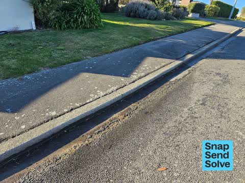

Street Gutters / Storm Water2 Scarborough Road
the drain on the way to the boat ramp is under a large amount of dirt. it is next to the yellow line. estimated 1 cu meter of soil and sediment in this…

Water Leak17 Godley Drive
water leak from grass verge across footpath getting worse. outside 17 Godley Drive


Graffiti on a fence, building or structureNicholson Park 142 Scarborough Road
Flowers track: on fence railing
Reports per year up 29% 2024→2025
15
9
16
12
17
16
18
41
19
71
20
52
21
52
22
97
23
120
24
106
25
137
What gets reported
Exactly what people say
How fast the council fixes things here 1,429 finished jobs on record
The median council work order pinned in Scarborough took 7 days to resolve, the city-wide median is 3 days, so this ground runs slower than the city as a whole. The slowest tenth waited 5 months or longer. 62 tickets are open here now, the oldest was filed 25 October 2021.
Work orders, not the resident reports above, the council’s MyCouncilTicket stream, and one job can appear in both. A median counts only finished jobs; open ones are named as open, never averaged in. The ticket roll · the whole city’s fix times.
The suburb today
Schools here
Zoned for Christchurch Adventist School · Hillview Christian School · Marian College · Middleton Grange School · St Thomas of Canterbury College · Sumner School · and 2 more zones, the drawn zone is indicative; the Ministry’s written scheme is the legal boundary.
The green here 4
- Whitewash ReserveRegional · 9 ha
- Nicholson Park4 ha · playground, 4 pieces
- Giants NoseRegional · 2 ha
- Sea Spray Reserve
Parks and reserves in the council’s open data, a park lands in the suburb its centre falls inside. The whole roll is at /parks.
The names on this ground 5
The Crown’s 2011 classification drew 4.7% of this outline inside the residential red zone. A mapped area files under the suburb its middle sits in, and a classification is the record of a decision, not a finding about an address; the whole line is drawn at /redzone.
The mapped tsunami extent covers 1% of this outline. The sea’s modelled reach, not a prediction, the plan’s inundation line, not the evacuation zones; the share is read from a sampled join. The whole extent is drawn at /tsunami.
The plan’s slope-hazard bands cover 9% of this outline, about 6 hectares, cliff collapse management area 2, mass movement management area 1. The broad remaining-instability overlay covers 85% of it besides, the plan’s background watch over the hill country. Shares read from a sampled join; a management overlay, not a prediction. The whole watch is drawn at /slope.
The files record 23 parcels of made or characterised ground inside this outline, mostly compacted hardfill, loess, buried topsoil. A record is the file’s word on what was laid, not a fresh survey; the whole layer is drawn at /fill.
The rockfall survey mapped 457 rocks inside this outline across 93 survey pins, 381 came down, 31 still wobble easy. A pin may stand for a cluster and marks where the survey saw the rock, not where it is now; the whole survey is drawn at /boulders.
The 2019 liquefaction study put 31% of this outline in the "unlikely" class, 34% of the outline fell inside an assessed area. A class is the model’s verdict on a patch of ground, not a finding about an address; the whole study is drawn at /vulnerability.
The council’s structure register stands 39 assets on this ground, 32 sets of steps, 3 boat ramps, 2 boardwalks, 1 ramp, sited at Whitewash Reserve, Nicholson Park, Marriner St And Flowers Track, Port Hills 10 Rrz Land. The register’s site names are its own labels for the ground an asset stands in; the layer is drawn at the map.
The register counts 280 living trees inside this outline, 2 veterans among them, 3 carrying a protection, mostly Maritime pine, Blue Atlas Cedar, Radiata Pine (w). The file remembers 123 trees felled here. A tree record is the register’s word on what stands or stood; the whole canopy is drawn at /trees.
The plan files 60% of this outline under Residential Hills, 60% residential, the rest mostly Transport 13%, Open Space Coastal 8%, 94% of the outline fell inside a mapped zone. A zone is a permission, not a description, the mix is read from a sampled join of the plan’s polygons; the whole district is drawn at /zones.
The plan’s schedule of sites significant to Ngāi Tahu covers 100% of this outline, about 69 hectares, ngā tūranga tūpuna, ngā wai. Shares read from a sampled join; a recognition overlay, not a catalogue. The whole schedule is drawn at /cultural.
The plan’s landscape schedules cover 19% of this outline, about 13 hectares across 4 scheduled areas, 12% of it outstanding, the plan’s strongest landscape standing, and 64% of it sits inside the coastal environment. Shares read from a sampled join; a protection overlay, not a ranking of views. The kept view is drawn at /landscape.
No high-hazard flood area covers this outline. The broader flood-management watch covers 1% of it, Sumner. Shares read from a sampled join; a model’s map, not a promise. The waiting water is drawn at /flood-hazard.
The plan’s water-margin layers cross this outline, 17 classified reaches, the plan calling Scarborough Outfall and Highview Lane Drain by name, 5% of it inside the setback strips, the widest holding 20 m off the bank, and an esplanade line holds a public edge here. The margin is the plan’s drawing, not a survey of the bank; the reaches, strips and held edges are mapped at /water-margin.
The rebuild’s cameras filed 132 photographs on this ground, 2012–2015, stormwater work mostly. Each frame is a receipt the dig left behind, a work log, not a survey of what stands now; the whole record is drawn at /rebuild.
The pedal network threads this ground, 1.9 km of cycleway crosses the outline, Te Ara Ihutai Coastal Pathway. A segment counts under every suburb its path enters; the whole network is drawn at /cycleways.
The remembered names stand on this ground, 13 inscribed plaques, Nicholson Park, Whitewash Reserve, Scarborough Beach among the grounds. The plaque is the register’s pin, not a surveyed spot; the whole roll is kept at /plaques.
The rulebook binds this ground, 10 drawn instruments, 9 of them dog rules, 1 alcohol ban; the outline sits inside the takiwā of Te Ngai Tuahuriri Runanga. The bylaw is the instrument, this the map of it, the whole rulebook is drawn at /rules.
GeoNet’s catalogue puts 5 magnitude-3+ epicentres inside this outline since the sequence opened, the biggest a M4.2 in 2011. An epicentre is where the instruments placed the break, not a measure of the shaking here; the whole catalogue is counted at /sequence, the live record is /quakes, and the story in plain language is the earthquakes explainer.
- Giants Noseheadland
- Moki Pointheadland
- Sumner Headheadland
- Whitewash Headheadland
- Sumner Boating & Fishing Club Jettyjetty
The named waterways, bays, headlands, monuments, summits and old sites OpenStreetMap puts inside this outline, a pin is the mapper’s own; a waterway belongs to every suburb it crosses. Every roll, counted: /geography.
The crash record 3 injury crashes
3 crashes that hurt somebody on record inside Scarborough's outline, 2 seriously hurt, nobody killed.
The corner that keeps appearing: Heberden Avenue at Esp, 1 injury crash.
The crime record 114 recorded victimisations
114 victimisations on the Police record inside Scarborough’s outline, September 2022–August 2026, mostly theft, about 8 a year per 1,000 residents. Up 213% on the year before. Reported is not all, how much never reaches the record depends on the offence.
Businesses here 2 in the directory
2 premises in Scarborough across 2 kinds, from OpenStreetMap, the council’s licensed-premises register and its 2024 Find Christchurch directory. Each kind below opens at this suburb’s shelf.
Before any of that
On the register here
Documents 40
What the archive’s sources say about Scarborough, titled for it, turned up by a search for one of its places, or carrying its name in the text. These are leads and citations: the originals live at the provider, linked from each row.
1840s
1850s
41860s
331870s
1031880s
211890s
191900s
171910s
171920s
221930s
181940s
41950s
31960s
41970s
21980s
1990s
302000s
282010s
72020s
LAST- NIGHT'S MEETING. (New Zealand Gazette and Wellington Spectator, 15 December 1841)
…istowell s st ives w praed salisbury wyndham brodie s sandwich sir t troubridge s lindsay scarborough sir f trench sir j johnstone sheffield parker s ward s shields south wawn s shaftesbury lord howar…New Zealand Gazette and Wellington Spectator · Papers Past · National Library of New Zealand · · text held
MARRIED. (Lyttelton Times, 21 November 1857)
…esq of hull and canterbury new zealand youngest son of the late samuel beswick esq jp of scarborough to matilda emily youngest daughter of t horncastle esq of hull…Lyttelton Times · Papers Past · National Library of New Zealand · · text held
Page 5 Advertisements Column 3 (Lyttelton Times, 20 April 1861)
…pprill joseph william rangiora hotel rangiora pearce edwin heathcote arms heathcote ferry scarborough george bruce hotel akaroa bilk alfred river street heathcote tankard henry sawyers arms papanui tr…Lyttelton Times · Papers Past · National Library of New Zealand · · text held
Page 5 Advertisements Column 5 (Lyttelton Times, 12 June 1861)
…olson frederick canterbury sumner day george canterbury arms akaroa daly james commercial scarborough george bruce waeckerle christian jacob french hotel christchurch barrett thomas c barrett hotel bi…Lyttelton Times · Papers Past · National Library of New Zealand · · text held
Page 6 Advertisements Column 1 (Lyttelton Times, 16 April 1862)
…ce session vi no 3 of the provincial council of canterbury general licenses akaroa george scarborough publican bruce hotel john anderson publican commercial hotel jacobwaeckerle publican french hotel…Lyttelton Times · Papers Past · National Library of New Zealand · · text held
Page 9 Advertisements Column 1 (Lyttelton Times, 19 April 1862)
…ce session vi no 3 of the provincial council of canterbury general licenses akaroa george scarborough publican bruce hotel john anderson publican commercial hotel jacob waeckerle publican french hotel…Lyttelton Times · Papers Past · National Library of New Zealand · · text held
LATEST TELEGRAMS. (Grey River Argus, 18 January 1872)
…london dec 12 the times cays that the prino contracted his jhessatlordlondesboroughs near scarborough earl chesterfield and several other gaests were attasked at the same t me sandringham 8 am the pri…Grey River Argus · Papers Past · National Library of New Zealand · · text held
Page 1 Advertisements Column 5 (Star, 17 January 1873)
…py may be obtained gratis of most respectable chemists or direct from the author dr rooke scarborough england on forwarding address and two penny stamps for postage agent for new zealand mr j baxter c…Star · Papers Past · National Library of New Zealand · · text held
Page 4 Advertisements Column 1 (Star, 14 March 1873)
…icine dealers in bottles at is 9d 4 bi and lis each and wholesale by jas m ckosby chemist scarborough enghi luvalids bhould read crosby pri treatise on diseases of the lungs and ir vessels a copy of w…Star · Papers Past · National Library of New Zealand · · text held
Page 4 Advertisements Column 1 (Star, 17 March 1873)
…icine dealers ih bottles at ls 9d 4s 6o nd lis each and wholesale by jas m crosby chemist scarborough england invalids should read crosby pri treatise on diseases of the lungs and ait vessels a copy o…Star · Papers Past · National Library of New Zealand · · text held
The rest are a search away, the whole shelf, for the name →
The wire on Scarborough 4 lately
Man dies after being pulled from Scarborough BeachThe news · Chris Lynch Media ·
Police, fire, St John and the Sumner lifeboat are responding to an ‘incident’ at Christchurch’s Scarborough Beach.The Press · Tina Law ·
Emergency crews respond to ‘incident’ at Christchurch’s Scarborough BeachThe news · The Press ·
Something seen — Scarborough Rd, Heathcote Ward, Canterbury, NZiNaturalist · tom_beard ·
44 more documents came up in searches for Scarborough's places and have not been read yet, a lead is a search result, not a fact, until somebody reads it.
Next door
Compare Scarborough with Sumner · te-onepoto-taylors-mistake · Richmond Hill · Clifton · Moncks Bay · Redcliffs, same record, side by side.
Questions, answered briefly
What is Scarborough?
Scarborough is a hillside suburb above Sumner in Christchurch, New Zealand. The public record holds 780 council reports for it, the first filed in June 2015.
How many people does the 2023 Census count for Scarborough?
About 3,414 people and 1,344 occupied private households (nearby SA1s): grouped from Stats NZ SA1 areas through this site’s suburb join. Indicative, not a LIM.
What gets reported in Scarborough?
780 reports on record, most often water & drains (234), trees & parks (184), roads & footpaths (180). 112 of them in the year to 13 October 2026.
How many crashes has Scarborough had?
3 injury crashes on the police record inside the suburb’s outline, 2 seriously hurt, nobody killed. The suburb’s crashes, mapped →
Did earthquakes strike under Scarborough?
GeoNet’s catalogue puts 5 magnitude-3+ epicentres inside the suburb’s mapped outline since the September 2010 mainshock, the biggest a M4.2 in 2011. An epicentre is where the instruments placed the break, not a measure of the shaking felt here. The whole sequence, counted → · The story, in plain language →
What stood in Scarborough before?
The heritage register holds 1 place here, Sumner Clock Tower and Setting. The written record goes back further: the shelf, for the name →
Every suburb in Christchurch → · Its decade, charted → · the whole A–Z →