
Bottle Lake, Christchurch
549 council reports since July 2015, the 85th busiest suburb in the city. 477 photographs on record. 1,090 people at the 2023 Census, 88 to the square kilometre across 12 km².
The record also holds about $580 a week to rent· 2023 Census snapshot· 477 photographs· 1 old photograph· 4 parks· 1 track· 1 name on the map· 10.5% of the outline mapped liquefied· the record drew water over 34% of the outline· the mapped tsunami reach covers 12% of the outline· the Ngāi Tahu schedule covers 1% of the outline· ecological sites over 10% of the outline· landscape schedules over 14% of the outline· high flood hazard over 2% of the outline· setback strips over 2% of the outline· 12 SCIRT photographs filed on this ground· 1.0 km of cycleway crosses the outline· 3 drawn rules bind this ground· 9 parcels of made ground· the 2019 model grades this ground mostly possible· 4 council structures on the register· 6 recreation register records· 132 trees on the register· the plan’s word on this ground· 4 epicentres inside the outline· 6 injury crashes· 95 recorded victimisations· 3 businesses· the council’s fix times· 40 documents· 5 mentions on the wire
Live source links
Link-outs to the source’s own live pages, chch.live does not copy their live values or source text.
Living here rent · the ground · the day-to-day
$580/week
middle half $508–$650
New bonds here ran at about $580 a week in the April–June 2026 quarter, the middle half of them between $508 and $650, across 21 bonds lodged, up 2% on a year ago. That’s about $30 a week above the city’s own quarter median of $550. Tenancy Services counts these under the much wider Parklands area, this locality sits inside it, so read the figure as the district’s.
By dwelling type and bedrooms, April–June 2026 quarter
- 3-bedroom house, $615 a week · 12 new bonds
- 1-bedroom house, $575 a week · 9 new bonds
Median and quartiles of weekly rents on new private bonds, by quarter. New bonds are fresh lodgements, not the whole rental stock; under five bonds the rent is withheld, and counts are randomly rounded. Source: Tenancy Services rental bond data: provisional while the bond system migrates.
The ground: the February 2011 survey drew liquefaction over 11% of it; the flood record drew water over 34% of it, the rest of the watch is drawn further down.
Day to day it holds 4 parks and 1 track, each is counted further down.
Lately the record’s mostly rubbish & dumping, 127 reports in the year to 12 October 2026, the newest 6 October 2026.
One for the quiz, Its busiest day on record was 7 November 2024, 9 reports in a single day.
2023 Census snapshot SA1 areas grouped here
About 4,011 people and 1,479 occupied private households in the “Parklands” statistical area, grouped from 25 SA1 areas. A wider statistical area stands in for this suburb, so this is a proxy rather than a count for the suburb boundary.
More of the 2023 Census
- Born overseas18% of stated birthplace
- European ethnicity88% of ethnicity responses
- Māori ethnicity17% of ethnicity responses
- Pacific Peoples ethnicity5% of ethnicity responses
- Asian ethnicity5% of ethnicity responses
- Households with internet89% of stated households
- Households with two or more vehicles60% of stated households
Ethnicity is a multiple-response measure, so those percentages are not meant to add to 100%.
Stats NZ’s 2023 Census uses fixed random rounding to base 3. Unavailable or confidential cells are left out, not treated as zero. individuals · households · geography · CC BY 4.0.
About the suburb
Bottle Lake is an area in the north-east of Christchurch with a low number of residents. Most of the area is covered by Bottle Lake Forest, which has since the mid-1970s become a popular recreation area.
As reported 477 on record
The suburb, back then 1 in the archive
Placed by the record’s locality join or the name in its own title, a lead, not a claim each frame stood here.
The shape of it outline © OpenStreetMap · recent reports, pinned
The record on Bottle Lake
- Bottle Lake enters the written record on 26 September 1871, “Page 1 Advertisements Column 1 (Star, 26 September 1871)”, Papers Past.
- “Bottle Lake” appears somewhere in 89 of the archive’s records, title, description or body.
- A Papers Past search for the name surfaced 30 records, leads by provenance, not by phrase.
- The first report the feed ever carried here: roading/streets, 2 July 2015, at 212-222 Lower Styx Rd.
- Its busiest day on record was 7 November 2024, 9 reports in a single day.
- The street that keeps coming up is Lower Styx Road, reported on 94 separate days.
- For elections the suburb’s centre falls inside Coastal ward, the Coastal-Burwood-Linwood community board is its local layer. The whole roll is at /wards.
Lately the newest reports

Graffiti on a playground or in a parkCanterbury
Graffiti on Bottle lake Park map. Location shown on the photograph of the map


Water FountainLandfill Ave
My camera is broken but I came across a badly leaking broken tap in bottle lake forest right where the trucks stop and wash their vehicles . There’s a big…

Facility - General RequestUnnamed Road
Motor bikes illegally in Bottle Lake Forest. Took photo while they were stopped outside the CCC compound on Hotel Road with number 4 on the gate. They rode off…
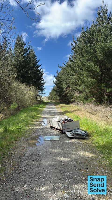
Dumped Rubbish120 Aston Dr
Dumped rubbish within bottle lake forest walking trail scattered right down walkway - people are gross! ??


General RequestBottle Lake Forest Park Waitikiri Drive
another idiot on a motorbike riding through Bottle Lake Forest. Went out past the Rangers area


Park - General Request26 Styx River Place
This rider on an unplated, noisy, green bike is riding in and around Bottle Lake Forest daily. Absolute menace to horses, walkers etc and will be a fire danger…
Reports per year up 74% 2024→2025
15
5
16
1
17
5
18
11
19
21
20
32
21
25
22
49
23
51
24
91
25
158
What gets reported
Exactly what people say
How fast the council fixes things here 883 finished jobs on record
The median council work order pinned in Bottle Lake took 9 days to resolve, the city-wide median is 3 days, so this ground runs slower than the city as a whole. The slowest tenth waited 4 months or longer. 42 tickets are open here now, the oldest was filed 14 June 2022.
Work orders, not the resident reports above, the council’s MyCouncilTicket stream, and one job can appear in both. A median counts only finished jobs; open ones are named as open, never averaged in. The ticket roll · the whole city’s fix times.
The suburb today
Schools here
Zoned for Christchurch Adventist School · Emmanuel Christian School · Mairehau High School · Marian College · Middleton Grange School · Ōuruhia Model School · and 4 more zones, the drawn zone is indicative; the Ministry’s written scheme is the legal boundary.
The green here 4
- Bottle Lake ForestRegional · 993 ha
- Bottle Lake Beach ParkRegional · 47 ha
- Sheppards Stream ReserveRegional · 5 ha
- Styx River Esplanade ReserveRegional · 3 ha
Parks and reserves in the council’s open data, a park lands in the suburb its centre falls inside. The whole roll is at /parks.
The tracks through here 1
- Walk and bike track through Bottle Lake3.3 km · Christchurch · walk · bike
Tracks in the council’s open data, a line belongs to every suburb it passes through. The whole network is at /tracks.
The names on this ground 1
The February 2011 survey drew mapped ground failure over 10.5% of this outline, about 131 hectares. A patch is a footprint, not a finding about an address; the count for the whole city is at /liquefaction.
The flood record drew water over 34.3% of this outline, about 426 hectares, across 2 named events. A patch is one event’s observation, not a live hazard finding; the whole record is drawn at /floods.
The mapped tsunami extent covers 12% of this outline, about 145 hectares. The sea’s modelled reach, not a prediction, the plan’s inundation line, not the evacuation zones; the share is read from a sampled join. The whole extent is drawn at /tsunami.
The files record 9 parcels of made or characterised ground inside this outline, mostly sand, compacted hardfill. A record is the file’s word on what was laid, not a fresh survey; the whole layer is drawn at /fill.
The 2019 liquefaction study put 94% of this outline in the possible class. A class is the model’s verdict on a patch of ground, not a finding about an address; the whole study is drawn at /vulnerability.
The council’s structure register stands 4 assets on this ground, 1 bridge, 1 ramp, 1 shelter, 1 boardwalk, sited at Bottle Lake Forest, Waimairi Beach Park. The register’s site names are its own labels for the ground an asset stands in; the layer is drawn at the map.
The recreation register keeps 6 records inside this outline, bookable surfaces for 4 disc golf, 1 bmx, plus a marked dog exercise area. Seasons and surfaces are the register’s record, not this week’s draw; the layer is drawn at the map.
The register counts 132 living trees inside this outline, 1 veteran among them, 5 carrying a protection, mostly Worplesdon Sweet Gum, English Oak, Gum. The file remembers 32 trees felled here. A tree record is the register’s word on what stands or stood; the whole canopy is drawn at /trees.
The plan files 60% of this outline under Open Space Natural, the rest mostly Rural Urban Fringe 23%, Open Space Coastal 7%. A zone is a permission, not a description, the mix is read from a sampled join of the plan’s polygons; the whole district is drawn at /zones.
The plan’s schedule of sites significant to Ngāi Tahu covers 1% of this outline, about 17 hectares, ngā wai. A silent-file precinct covers 1% of it besides, sensitive ground the plan flags without naming the sites. Shares read from a sampled join; a recognition overlay, not a catalogue. The whole schedule is drawn at /cultural.
The plan’s ecological schedules cover 10% of this outline, about 119 hectares across 3 scheduled sites, all protected under Schedule A. Shares read from a sampled join; a recognition overlay, not a survey. The whole ledger is drawn at /ecology.
The plan’s landscape schedules cover 14% of this outline, about 179 hectares across 6 scheduled areas, and 16% of it sits inside the coastal environment. Shares read from a sampled join; a protection overlay, not a ranking of views. The kept view is drawn at /landscape.
The plan’s flood map draws 2% of this outline inside high flood hazard ground, about 26 hectares across 2 mapped areas. The broader flood-management watch covers 31% of it, Lower Styx River, Avon River. 14 ponding spots are mapped here, where the models expect water to sit. Shares read from a sampled join; a model’s map, not a promise. The waiting water is drawn at /flood-hazard.
The plan’s water-margin layers cross this outline, 12 classified reaches, the plan calling Treleavens Drain and Styx River by name, 2% of it inside the setback strips, the widest holding 30 m off the bank, and an esplanade line holds a public edge here. The margin is the plan’s drawing, not a survey of the bank; the reaches, strips and held edges are mapped at /water-margin.
The rebuild’s cameras filed 12 photographs on this ground, 2012–2015. Each frame is a receipt the dig left behind, a work log, not a survey of what stands now; the whole record is drawn at /rebuild.
The pedal network threads this ground, 1.0 km of cycleway crosses the outline. A segment counts under every suburb its path enters; the whole network is drawn at /cycleways.
The rulebook binds this ground, 3 drawn instruments, 2 of them dog rules, 1 alcohol ban; the outline sits inside the takiwā of Te Ngai Tuahuriri Runanga. The bylaw is the instrument, this the map of it, the whole rulebook is drawn at /rules.
GeoNet’s catalogue puts 4 magnitude-3+ epicentres inside this outline since the sequence opened, the biggest a M3.7 in 2010. An epicentre is where the instruments placed the break, not a measure of the shaking here; the whole catalogue is counted at /sequence, the live record is /quakes, and the story in plain language is the earthquakes explainer.
- Styx Riverwaterway · 19.8 km
The named waterways, bays, headlands, monuments, summits and old sites OpenStreetMap puts inside this outline, a pin is the mapper’s own; a waterway belongs to every suburb it crosses. Every roll, counted: /geography.
The crash record 6 injury crashes
6 crashes that hurt somebody on record inside Bottle Lake's outline, 2 seriously hurt, nobody killed.
The corner that keeps appearing: Lower Styx Road at Dunlops Road, 2 injury crashes.
The crime record 95 recorded victimisations
95 victimisations on the Police record inside Bottle Lake’s outline, September 2022–August 2026, mostly theft, about 6 a year per 1,000 residents. Up 45% on the year before. Reported is not all, how much never reaches the record depends on the offence.
Businesses here 3 in the directory
3 premises in Bottle Lake across 3 kinds, from OpenStreetMap, the council’s licensed-premises register and its 2024 Find Christchurch directory. Each kind below opens at this suburb’s shelf.
Before any of that
Documents 40
What the archive’s sources say about Bottle Lake, titled for it, turned up by a search for one of its places, or carrying its name in the text. These are leads and citations: the originals live at the provider, linked from each row.
1870s
61880s
81890s
431900s
131910s
71920s
21930s
91940s
2010s
Page 1 Advertisements Column 1 (Star, 26 September 1871)
…ellaneous goods sale at noon 4361 mo be let a two-roomed cottage x and 34 acres land near bottle lake employment given to occupant if a good agricultural labourer edward reece 4366 cbri��tchurch…Star · Papers Past · National Library of New Zealand · · text held
Painting of Bottle Lake
Reproduction of Painting of Bottle Lake by John Gibb. All Saints Church, Burwood collection…All Saints Church, Burwood collection · Canterbury Stories · Christchurch City Libraries ·
Page 2 Advertisements Column 6 (Star, 13 January 1886)
…d park styx 1976 anted boy to milk make himself nsefuj indoors polk and sons preston road bottle lake 1966 wi anted smart lyouth about 17 must be recommended apply box 102 post-office christchurch 191…Star · Papers Past · National Library of New Zealand · · text held
Page 1 Advertisements Column 2 (Star, 05 April 1889)
…n water obtainable at an easy distance the river avon being in front of the property with bottle lake and horseshoe take close to it thus affording plenty of ashing shooting aud boating the property i…Star · Papers Past · National Library of New Zealand · · text held
Page 1 Advertisements Column 4 (Star, 08 April 1889)
…n water obtainable at an easy distance the biver avon beidg in front of the property with bottle lake and horseshoe take olose to it thus afeording plenty of fishing shooting aud boating the property…Star · Papers Past · National Library of New Zealand · · text held
Christchurch Harriers. (Star, 22 July 1889)
…tertained the party in a royal manner they��ubsequently passed through burwood to mr king bottle lake property where the drag had been laid some very good-runs were then made it is to-be regretted tha…Star · Papers Past · National Library of New Zealand · · text held
OUR DEFENCES. (Star, 25 July 1889)
…estaary whilst to the northward axe tba swamps hgwwumtitftg the hoxseshod lagooa and the bottle lake which wottls render any movements from thafc direction islow and difficult it may thexeioze ba abs…Star · Papers Past · National Library of New Zealand · · text held
CHRISTCHURCH. (Star, 23 June 1890)
…nley v t wilson claim g iss mr stringer for defendant plaintiff bought a piece of land at bottle lake from a man named hole tho purchase being subject to the currency of a five years lease to a tenant…Star · Papers Past · National Library of New Zealand · · text held
New Brighton Steamer. (Star, 16 May 1891)
…an they can be by rail from port the districts outside of new brighton especially burwood bottle lake and papanui are great potato districts and we shall be as near them as or even nearer than the chr…Star · Papers Past · National Library of New Zealand · · text held
Latest Locals. (Star, 16 February 1892)
…ptain keece to the members of the canterbury mounted kifies will be held at his residence bottle lake tomorrow evening the members fall in at j 630 pm at the drillshed a popular journal a copy of the…Star · Papers Past · National Library of New Zealand · · text held
The rest are a search away, the whole shelf, for the name →
The wire on Bottle Lake 5 lately
Mouse-ear Chickweeds seen — Bottle Lake, Christchurch 8083, New ZealandiNaturalist · melwhiting ·
Something seen — Bottle Lake, Christchurch 8083, New ZealandiNaturalist · dmc838 ·
Flatworms seen — Bottle Lake, Christchurch 8083, New ZealandiNaturalist · melwhiting ·
Great Pond Snail seen — Bottle Lake, Christchurch 8083, New ZealandiNaturalist · melwhiting ·
Kawaupaka (Little Shag) seen — Bottle Lake, Christchurch 8083, New ZealandiNaturalist · melwhiting ·
Next door
Compare Bottle Lake with Parklands · Marshland · Ouruhia · Spencerville · Waimairi Beach · North New Brighton, same record, side by side.
Questions, answered briefly
What is Bottle Lake?
Bottle Lake is an area in the north-east of Christchurch with a low number of residents. The public record holds 549 council reports for it, the first filed in July 2015.
How many people live in Bottle Lake?
1,090 people at the 2023 Census, 88 per square kilometre across 12 km².
How many people does the 2023 Census count for Bottle Lake?
About 4,011 people and 1,479 occupied private households (wider SA2 stand-in): grouped from Stats NZ SA1 areas through this site’s suburb join. Indicative, not a LIM.
What gets reported in Bottle Lake?
549 reports on record, most often rubbish & dumping (243), trees & parks (134), roads & footpaths (54). 127 of them in the year to 12 October 2026.
How many crashes has Bottle Lake had?
6 injury crashes on the police record inside the suburb’s outline, 2 seriously hurt, nobody killed. The suburb’s crashes, mapped →
Did earthquakes strike under Bottle Lake?
GeoNet’s catalogue puts 4 magnitude-3+ epicentres inside the suburb’s mapped outline since the September 2010 mainshock, the biggest a M3.7 in 2010. An epicentre is where the instruments placed the break, not a measure of the shaking felt here. The whole sequence, counted → · The story, in plain language →
Every suburb in Christchurch → · Its decade, charted → · the whole A–Z →