28 Park Terrace, Christchurch Central City
24 reports on record since March 2016 · 22 with photographs. The street’s heaviest record is 82A Park Terrace — 58 reports on file. Indicative rating valuation and school zones, hazards, bin day and what stood here before.
What gets reported here
- Roading/Streets — 3
- Graffiti on a fence, building or structure — 3
- Parks — 2
- Graffiti on a traffic light pole or cabinet, or wa — 2
- General Request — 2
- Water Supply — 1
Photographed here 22 on record


Reported here
 Damaged Street Light —
 Grafitti
 Street Gutters / Storm Water —
 Blocked/ drains on berm
 Graffiti on a fence, building or structure —
 Grafitti
 General Request —
 Debris after racing
- Park - General Request —
On 28 May 2026, two female workers in City care vehicle registration PKR230 stopped opposite Cathedral Grammar office to tidy up the Azalea
 General Request —
 Tag
 Damaged Street Sign —
 Tag
 Graffiti on a fence, building or structure —
 graffiti on light lamp post pole
 Overgrown Vegetation —
 Busy Public foot path being occluded by vigourous growth of azaleas plus the looks to be some walnut tree suckers that are growing and need
 Litter —
 Hello Council Person. The two road cones were left after the Christmas in the Park event. It appears one has Delta written on it , I'm no
 Flooding —
 Flooded Cycle Path The two-way cycle path on Park Tce is flooded across both lanes opposite Cathedral Grammar School. Length of flooding is
 Pavement - General —
 Hello there! I have previously sent a SnapSolve requesting that the cavity around the recently replaced pole is filled with dirt and grasse
 Facility - General Request —
 Hello Could consideration be given to replacing missing soil around the base of the street light on the council berm. The hole is hazardous
 Graffiti on a fence, building or structure —
 Hello Council person Could the council kindly arrange to have this tag removed ? Frustratingly many meters of Park Terrace has had poles fen
 Graffiti on a traffic light pole or cabinet, or wa —
 Hello please forward to Orion
 Graffiti on a traffic light pole or cabinet, or wa —
 Hello please see tag on this Orion light Post. ?Could consideration be given to removing the tag thank you.
 Poles and Signage - General —
 Cycle way roading infrastructure damaged and lying on grass bearm.
- Graffiti —
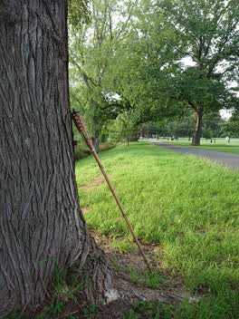 Parks —
 Oil torchere in Hagley Park, against a tree opposite Chester St West.
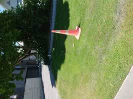 Roading/Streets —
 The berm at 28 Park Terrace, City, has had a leaking toby box for a couple of months. There is a cone on it but that won't be enough to sto
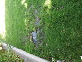 Water Supply —
 Leaking toby box. Was fixed around a week ago.
Roading/Streets —
Post has been run over (again) on Little Fantasy Island, cnr Park Terrace and Kilmore.
Parks —
The lamp post in Hagley Park near the NW end of the Armagh bridge has had the back cover off since last weekend. The cover is lying in the g
Roading/Streets —
Hole in footpath. Neighbours builders have sprayed dazzle paint as they saw a woman trip.
Also reported on Park Terrace
- 82A Park Terrace — 58 reports
- 78 Park Terrace — 39 reports
- 34 Park Terrace — 31 reports
- 62 Park Terrace — 29 reports
- 42 Park Terrace — 28 reports
- 82 Park Terrace — 26 reports
- 104 Park Terrace — 25 reports
- 76 Park Terrace — 16 reports
The street’s crash record
NZTA’s record names Park Terrace in 27 crashes that hurt somebody since 2006 — 1 person killed, 0 seriously hurt.
The green nearby
- Hagley Park North — 25 m to the edge · Sports ground · 91 ha
- Armagh Reserve — 82 m to the edge
- Cranmer Square — 146 m to the edge · Botanic · 2 ha
- Botanic Gardens — 174 m to the edge · Botanic · 21 ha
- Victoria Triangles — 393 m to the edge
Parks within half a kilometre, measured to the boundary — the council’s open data.
The civic shelf nearby
- Rolleston Avenue — 346 m away · Car park
- Armagh St — 393 m away · Car park
- Aldersgate — 410 m away · Car park
Libraries, halls and the rest within half a kilometre — the council’s open data.
On the doorstep
- 50 Bistro — 167 m away · Restaurants
- The George Hotel — 168 m away · Hotels
- The George — 175 m away · Hotels
- Christchurch Running Tours — 194 m away · Attractions
Businesses within four hundred metres, measured at the pin — OpenStreetMap and the council directories.
The bus nearby
- Park Tce near Chester St W — 63 m away · route 8
- Park Tce near Peterborough St — 228 m away · route 8
The closest Metro stops, within four hundred and fifty metres.
The tracks through here
- Walk and bike track through Christchurch Central City — 13 m to the line · walk · bike
- Walk and bike track through Christchurch Central City — 24 m to the line · walk · bike
- Walk and bike track through Christchurch Central City — 72 m to the line · walk · bike
- Walk and bike track through Christchurch Central City — 150 m to the line · walk · bike
- Walk and bike track through Christchurch Central City — 163 m to the line · walk · bike
Tracks whose line passes within half a kilometre, measured to the line itself — the council’s open data.
The named ground
Named water within 500 m of this address, measured to the line or the edge; Named places within 1.5 km of this address; the council’s own structure register — bridges, boardwalks and steps standing nearby — the open map’s record.
The remembered names nearby
- Mischa Kuball / Solidarity Grid, 2014 / Mexico City — 27 m away ·
Mischa Kuball / Solidarity Grid, 2014 / MEXICO CITY
· 2013 - Mischa Kuball / Solidarity Grid, 2013 / Adelaide — 32 m away ·
Mischa Kuball / Solidarity Grid, 2013 / ADELAIDE
· 2013 - Mischa Kuball / Solidarity Grid, 2013 / Kurashiki — 33 m away ·
Mischa Kuball / Solidarity Grid, 2013 / KURASHIKI
· 2013
Inscribed plaques within two hundred and fifty metres — the register’s pins, not surveyed spots. The whole roll is at /plaques.
Renting nearby
new bonds in Christchurch Central City ran about $508 a week — $42 below the city median of $550 — the suburb page keeps the rent record →.
What was here — Former St Margaret's School Building and Setting
106 m away · 25A Cranmer Square · located to ±24 m · the place’s own record →
On the register. Nothing researched here yet.
What was here — Former Dwelling and Setting, Inveresk
142 m away · 17 Armagh Street · located to ±15 m · the place’s own record →
On the register. Nothing researched here yet.
What was here — Hagley Park Bridge and Setting
164 m away · located to ±18 m · the place’s own record →
On the register. Nothing researched here yet.
What was here — Dwelling and Setting, Red House
174 m away · 25 Armagh Street · located to ±10 m · the place’s own record →
On the register. Nothing researched here yet.
What was here — Dwelling and Setting
176 m away · located to ±12 m · the place’s own record →
On the register. Nothing researched here yet.
The civic layer
This ground votes in Central ward — the Papanui-Innes-Central community board. Ward lines don’t always follow suburb lines; this one is measured at the pin, not the suburb’s centre.
What stood on this ground → · On the map → · From the air — the Crown’s aerials back to 1936; search the address on RetroLens →
Questions, answered briefly
24 council reports on record since March 2016 — most often roading/streets (3), graffiti on a fence, building or structure (3), parks (2).
Christchurch Central City, Christchurch — on Park Terrace.
The heritage register names 5 places at or beside it — Former St Margaret's School Building and Setting, Former Dwelling and Setting, Inveresk.
Hagley Park North — 25 m to its edge, 91 ha.