375 Durham Street North, Christchurch Central City
22 reports on record since March 2022 · 19 with photographs. The street’s heaviest record is 329 Durham Street North — 55 reports on file. Indicative rating valuation and school zones, hazards, bin day and what stood here before.
What gets reported here
- Graffiti somewhere else — 5
- Graffiti — 4
- Graffiti on a traffic light pole or cabinet, or wa — 2
- Graffiti on a fence, building or structure — 2
- General Request — 2
- Water Leak — 1
Photographed here 19 on record


Reported here
 Traffic Signals urgent safety issue —
At a certain point traveling on Durham St Nt before the Salisbury and Durham St Nt intersection there is obscurity from trees limiting the l
 Graffiti on a fence, building or structure —
 General Request —
 Graffiti on a traffic light pole or cabinet, or wa —
 Graffiti on a traffic light pole or cabinet, or wa —
 Graffiti somewhere else —
Graffiti
 Graffiti somewhere else —
 Graffiti somewhere else —
 Graffiti somewhere else —
 Graffiti on a fence, building or structure —
 Graffiti on a cabinet, pole or railway asset —
Black paint tags on traffic controller by 375 Durham Street North.
 Graffiti somewhere else —
 Damaged Street Sign —
Salisbury Street sign needs replacing at the corner of Durham Street North.
 Graffiti —
 Graffiti —
- Sewer - Leak / Blockage —
- Water Leak —
- Vandalism - General —
 Street Gutters / Storm Water —
Yet another completely blocked drain
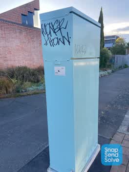 Graffiti —
Black paint tags on 2 sides of ATSC4 traffic controller on the corner of Salisbury and Durham Street North.
 General Request —
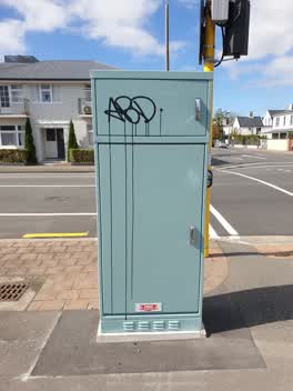 Graffiti —
Also reported on Durham Street North
- 329 Durham Street North — 55 reports
- 287 Durham Street North — 47 reports
- 398 Durham Street North — 36 reports
- 380 Durham Street North — 34 reports
- 423 Durham Street North — 28 reports
- 280 Durham Street North — 28 reports
- 414 Durham Street North — 25 reports
- 378 Durham Street North — 23 reports
The street’s crash record
NZTA’s record names Durham Street North in 24 crashes that hurt somebody since 2006 — 4 seriously hurt, nobody killed.
The green nearby
- Aldred Reserve — 52 m to the edge
- Victoria Triangles — 153 m to the edge
- Rose Historic Chapel Reserve — 281 m to the edge · Botanic
- Cranmer Square — 328 m to the edge · Botanic · 2 ha
- Victoria Square — 409 m to the edge · Botanic · 2 ha
Parks within half a kilometre, measured to the boundary — the council’s open data.
The civic shelf nearby
- Aldersgate — 411 m away · Car park
- Armagh St — 466 m away · Car park
Libraries, halls and the rest within half a kilometre — the council’s open data.
On the doorstep
- Focus Motels and Executive Suites — 69 m away · Motels
- Casamassima Italian Fare — 156 m away · Restaurants
- The Bog Irish Bar — 160 m away · Restaurants
- Surreal Hair — 161 m away · Business
Businesses within four hundred metres, measured at the pin — OpenStreetMap and the council directories.
The bus nearby
- Salisbury St near Victoria St — 159 m away · route 1, route 29, route 95
- Victoria St near Peterborough St — 184 m away · route 1, route 29, route 95
The closest Metro stops, within four hundred and fifty metres.
The tracks through here
- Walk and bike track through Christchurch Central City — 10 m to the line · walk · bike
- Walk and bike track through Christchurch Central City — 173 m to the line · walk · bike
- Walk and bike track through Christchurch Central City — 421 m to the line · walk · bike
- Walk and bike track through Christchurch Central City — 440 m to the line · walk · bike
- Walk and bike track through Christchurch Central City — 451 m to the line · walk · bike
Tracks whose line passes within half a kilometre, measured to the line itself — the council’s open data.
The named ground
Named water within 500 m of this address, measured to the line or the edge; Named places within 1.5 km of this address; the council’s own structure register — bridges, boardwalks and steps standing nearby — the open map’s record.
The remembered names nearby
- Aldred Reserve plaque — 63 m away ·
ALDRED PARK / IN 1993 A SUGGESTION WAS PUT TO THE CHRISTCHURCH CITY COUNCIL BY THE VICTORI
· 2004 - Victoria Triangles plaque — 222 m away · 2014
- Diamondjubilee / 1837 - 1897 — 225 m away ·
DiamondJubilee / 1837 - 1897
· 2009
Inscribed plaques within two hundred and fifty metres — the register’s pins, not surveyed spots. The whole roll is at /plaques.
Renting nearby
new bonds in Christchurch Central City ran about $508 a week — $42 below the city median of $550 — the suburb page keeps the rent record →.
What was here — Jubilee Clock Tower and Setting
227 m away · 95 Victoria Street · located to ±5 m · the place’s own record →
On the register. Nothing researched here yet.
What was here — Victoria Mansions and Setting
228 m away · F/91 Victoria Street · located to ±21 m · the place’s own record →
On the register. Nothing researched here yet.
What was here — Dwelling and Setting
230 m away · 18 Beveridge Street · located to ±8 m · the place’s own record →
On the register. Nothing researched here yet.
The civic layer
This ground votes in Central ward — the Papanui-Innes-Central community board. Ward lines don’t always follow suburb lines; this one is measured at the pin, not the suburb’s centre.
What stood on this ground → · On the map → · From the air — the Crown’s aerials back to 1936; search the address on RetroLens →
Questions, answered briefly
22 council reports on record since March 2022 — most often graffiti somewhere else (5), graffiti (4), graffiti on a traffic light pole or cabinet, or wa (2).
Christchurch Central City, Christchurch — on Durham Street North.
The heritage register names 3 places at or beside it — Jubilee Clock Tower and Setting, Victoria Mansions and Setting.
Aldred Reserve — 52 m to its edge.