40 Lichfield Street, Christchurch Central City
14 reports on record since March 2018 · 13 with photographs. The street’s heaviest record is 160 Lichfield Street — 37 reports on file. Indicative rating valuation and school zones, hazards, bin day and what stood here before.
What gets reported here
Photographed here 13 on record


Reported here
 Damaged Street Sign —
Kia ora, The Give Way sign at the Justice Precinct vehicle entrance has been knocked down. Unfortunately some of the baseplate is snapped of
 Graffiti on a fence, building or structure —
graffiti on light lamp post pole nearby
 Rubbish and Bins - General —
A CCC recycling bin was seized as part of a Police investigation some years ago in Operation Medbury. That bin is no longer required as an e
 Water Leak —
Leaking for hydrant
 Water Leak —
 Facility - General Request —
Sit needs to be fix's
 Pavement - General —
Hi this seat has been removed from the ground. It's outside the police station. Thanks julie
 Graffiti on a cabinet, pole or railway asset —
KP black paint tag on Rockgas asset by 40 Lichfield Street.
 Graffiti somewhere else —
 Graffiti somewhere else —
- Rubbish and Bins - General —
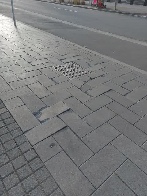
 Roading/Streets —
There are some loose pavers sticking out of the ground slightly. I tripped over these a few days ago and now have a large bruise.
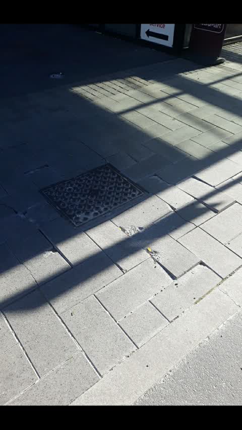
 Roading/Streets —
The pavement stones are quite uneven in this area (I suspect due to the amount of trucks that drive down Plymouth Lane to make deliveries).
Roading/Streets —
Please arrange for weeding of the 2 areas beside the trees outside new Lichfield st carpark thanks
Also reported on Lichfield Street
- 160 Lichfield Street — 37 reports
- 84 Lichfield Street — 27 reports
- 90 Lichfield Street — 25 reports
- 71 Lichfield Street — 25 reports
- 116 Lichfield Street — 22 reports
- 60 Lichfield Street — 19 reports
- 140 Lichfield Street — 19 reports
- 81 Lichfield Street — 18 reports
The street’s crash record
NZTA’s record names Lichfield Street in 71 crashes that hurt somebody since 2006 — 14 seriously hurt, nobody killed.
The green nearby
- Friendship Corner — 132 m to the edge · Botanic
- Tiffany Reserve — 169 m to the edge
- Bridge Of Remembrance — 182 m to the edge · Botanic
- City Mall — 210 m to the edge
- High Street Triangles — 270 m to the edge
Parks within half a kilometre, measured to the boundary — the council’s open data.
The civic shelf nearby
- Re:start - Lichfield St — 106 m away · Car park
- Triangle — 264 m away · Car park
- Scales — 344 m away · Car park
- Civic Offices — 401 m away · Council office
Libraries, halls and the rest within half a kilometre — the council’s open data.
On the doorstep
- Little Fish Co. — 81 m away · Seafood
- The General Store — 81 m away · Business
- J-Bings — 84 m away · Fast food
- The Mediterranean Food Co — 86 m away · Cafés
Businesses within four hundred metres, measured at the pin — OpenStreetMap and the council directories.
The bus nearby
- Bus Interchange (Intercity stop) — 178 m away · route 3, route 8, route 80
- Bus Interchange (Platform A) — 181 m away · route 3, route 5, route 60, route 80, route 81, route 84, route 85, route 86
The closest Metro stops, within four hundred and fifty metres.
The tracks through here
- Walk and bike track through Christchurch Central City — 86 m to the line · walk · bike
- Walk and bike track through Christchurch Central City — 120 m to the line · walk · bike
- Walk and bike track through Christchurch Central City — 133 m to the line · walk · bike
- Walk and bike track through Christchurch Central City — 139 m to the line · walk · bike
- Walk and bike track through Christchurch Central City — 349 m to the line · walk · bike
Tracks whose line passes within half a kilometre, measured to the line itself — the council’s open data.
The named ground
Named water within 500 m of this address, measured to the line or the edge; Named places within 1.5 km of this address; the council’s own structure register — bridges, boardwalks and steps standing nearby — the open map’s record.
The remembered names nearby
- The Chapel Is Open 1 Pm to 4 Pm Daily Closed Sundays — 163 m away ·
THE CHAPEL IS OPEN 1 PM TO 4 PM DAILY CLOSED SUNDAYS & CHRISTMAS DAY
· 2009 - Friendship Corner / Sister Cities — 173 m away ·
FRIENDSHIP CORNER / Sister Cities / (list largely illegible on inlay)
· 2010 - Planted on 14th April 1983 by His Excellency Premier Zhao — 175 m away ·
PLANTED ON 14TH APRIL 1983 BY HIS EXCELLENCY PREMIER ZHAO ZIYANG OF THE PEOPLE'S REPUBLIC
· 2009
Inscribed plaques within two hundred and fifty metres — the register’s pins, not surveyed spots. The whole roll is at /plaques.
Renting nearby
new bonds in Christchurch Central City ran about $508 a week — $42 below the city median of $550 — the suburb page keeps the rent record →.
What was here — St Michael's School Hall and Setting
135 m away · 243 Durham Street South · located to ±14 m · the place’s own record →
On the register. Nothing researched here yet.
What was here — St Michael's School Stone Building and Setting
139 m away · located to ±16 m · the place’s own record →
On the register. Nothing researched here yet.
What was here — St. Michael and All Angels Church & Setting
152 m away · 90 Oxford Terrace · located to ±25 m · the place’s own record →
On the register. Nothing researched here yet.
What was here — Former Dwelling and Setting
168 m away · 95 Oxford Terrace · located to ±18 m · the place’s own record →
On the register. Nothing researched here yet.
What was here — St Michael and All Angels Church Belfry and Setting
175 m away · 90 Oxford Terrace · located to ±5 m · the place’s own record →
On the register. Nothing researched here yet.
The civic layer
This ground votes in Central ward — the Papanui-Innes-Central community board. Ward lines don’t always follow suburb lines; this one is measured at the pin, not the suburb’s centre.
What stood on this ground → · On the map → · From the air — the Crown’s aerials back to 1936; search the address on RetroLens →
Questions, answered briefly
14 council reports on record since March 2018 — most often roading/streets (3), water leak (2), rubbish and bins - general (2).
Christchurch Central City, Christchurch — on Lichfield Street.
The heritage register names 5 places at or beside it — St Michael's School Hall and Setting, St Michael's School Stone Building and Setting.
Friendship Corner — 132 m to its edge.