
Edgeware, Christchurch
5,238 council reports since June 2015, the 25th busiest suburb in the city. 4,387 photographs on record. 5,000 people at the 2023 Census, 5,157 to the square kilometre across 1.0 km².
The record also holds about $525 a week to rent· 2023 Census snapshot· 4,387 photographs· 2 old photographs· 3 parks· 1 place of worship· 2 tracks· 1 name on the map· 81.7% of the outline mapped liquefied· the record drew water over 27% of the outline· inside a managed flood catchment· noise overlays over 1% of the outline· setback strips over 2% of the outline· 76% of the outline inside the plan’s density overlays· 1,741 SCIRT photographs filed on this ground· 10.7 km of cycleway crosses the outline· 1 remembered name on this ground· 7 drawn rules bind this ground· 3 parcels on the dangerous-work register· 24 parcels of made ground· 2 parcels with a cleanup on file· the 2019 model grades this ground mostly high· 4 council structures on the register· 15 recreation register records· 730 trees on the register· the plan’s word on this ground· 1% of the outline reserved· the plan’s exceptions touch 0% of the outline· 135 injury crashes· 1,159 recorded victimisations· 23 bus stops· 52 businesses· the council’s fix times· 40 documents· 5 mentions on the wire
Live source links
Link-outs to the source’s own live pages, chch.live does not copy their live values or source text.
Living here rent · the ground · the day-to-day
$525/week
middle half $470–$580
New bonds here ran at about $525 a week in the April–June 2026 quarter, the middle half of them between $470 and $580, across 108 bonds lodged, up 6% on a year ago. That’s about $25 a week below the city’s own quarter median of $550. Tenancy Services counts these under the “Edgeware” statistical area, close to this suburb’s outline, not exactly it.
By dwelling type and bedrooms, April–June 2026 quarter
- 1-bedroom house, $520 a week · 63 new bonds
- 2-bedroom house, $510 a week · 15 new bonds
- 2-bedroom apartment, $473 a week · 9 new bonds
- 3-bedroom house, $680 a week · 9 new bonds
- 2-bedroom flat/unit, $433 a week · 6 new bonds
Median and quartiles of weekly rents on new private bonds, by quarter. New bonds are fresh lodgements, not the whole rental stock; under five bonds the rent is withheld, and counts are randomly rounded. Source: Tenancy Services rental bond data: provisional while the bond system migrates.
The ground: the February 2011 survey drew liquefaction over 82% of it; the flood record drew water over 27% of it, the rest of the watch is drawn further down.
Day to day it holds 3 parks, 1 place of worship, 2 tracks and 23 bus stops, each is counted further down.
Lately the record’s mostly graffiti & vandalism, 574 reports in the year to 12 October 2026, the newest 11 October 2026.
One for the quiz, Its busiest day on record was 23 June 2018, 56 reports in a single day.
2023 Census snapshot SA1 areas grouped here
About 4,404 people and 2,058 occupied private households in the “Edgeware South” and “Edgeware North” areas, grouped from 31 SA1 areas. This exact statistical-area match is close to this suburb’s outline, not exactly it.
More of the 2023 Census
- Born overseas36% of stated birthplace
- European ethnicity71% of ethnicity responses
- Māori ethnicity10% of ethnicity responses
- Pacific Peoples ethnicity3% of ethnicity responses
- Asian ethnicity23% of ethnicity responses
- Households with internet84% of stated households
- Households with two or more vehicles41% of stated households
Ethnicity is a multiple-response measure, so those percentages are not meant to add to 100%.
Stats NZ’s 2023 Census uses fixed random rounding to base 3. Unavailable or confidential cells are left out, not treated as zero. individuals · households · geography · CC BY 4.0.
About the suburb
Edgeware is a suburb of Christchurch, New Zealand, to the north of the central city. It is centred on a cluster of some 20 shops that make up Edgeware Village on Edgeware Road near Colombo Street's northern end.
As reported 4,387 on record
The suburb, back then 2 in the archive
Placed by the record’s locality join or the name in its own title, a lead, not a claim each frame stood here.
The shape of it outline © OpenStreetMap · recent reports, pinned
The record on Edgeware
- Edgeware enters the written record on 19 January 1861, “CHRISTCHURCH. (Lyttelton Times, 19 January 1861)”, Papers Past.
- “Edgeware” appears somewhere in 410 of the archive’s records, title, description or body.
- A Papers Past search for the name surfaced 30 records, leads by provenance, not by phrase.
- The first report the feed ever carried here: rubbish/recycling, 9 June 2015, at 172A.
- Its busiest day on record was 23 June 2018, 56 reports in a single day.
- The street that keeps coming up is Geraldine Street, reported on 406 separate days.
- For elections the suburb’s centre falls inside Innes ward, the Papanui-Innes-Central community board is its local layer. The whole roll is at /wards.
Lately the newest reports

Pavement - Damaged64 Edward Avenue
guard rail/fence impacted/damaged by vehicle accident at this corner a few months ago.


Roads - General180 Geraldine St
Note the tyre tracks. Does this ugly street eyesore not tell you that the roading alignment of this chicane in Geraldine Street is wrong and needs correcting?

Dumped Rubbish124 Champion Street
bag of rubbish under the sign at Champion St reserve. Please just take it next time you empty the rubbish bin in the reserve


Abandoned Vehicle92 Warrington St
Dumped car after car crash outside our property at 4am on Friday 9th October. Car is still sitting there and still had the keys in it. Last night the keys were…

Park - General RequestCanterbury
Broken pavement on top of soggy ground, possibly a broken pipe due to vehicle damage. Broken pavement is new, soggy ground has already been reported

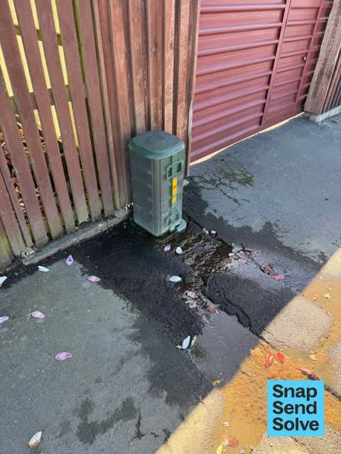
Water Leak205 Edgeware Rd
Hi there There is quite a lot of water leaking from a box on Edgeware Road I walk down there daily with my dog but the water flow looks like it has been…
Reports per year down 20% 2024→2025
15
48
16
276
17
191
18
304
19
494
20
354
21
468
22
584
23
594
24
832
25
663
What gets reported
Exactly what people say
How fast the council fixes things here 6,960 finished jobs on record
The median council work order pinned in Edgeware took 3 days to resolve, the city-wide median is 3 days, so this ground runs faster than the city as a whole. The slowest tenth waited 2 months or longer. 139 tickets are open here now, the oldest was filed 28 May 2021.
Work orders, not the resident reports above, the council’s MyCouncilTicket stream, and one job can appear in both. A median counts only finished jobs; open ones are named as open, never averaged in. The ticket roll · the whole city’s fix times.
The suburb today
Schools here
Zoned for Christchurch Adventist School · Emmanuel Christian School · Mairehau High School · Marian College · Middleton Grange School · Pareawa Banks Avenue School · and 7 more zones, the drawn zone is indicative; the Ministry’s written scheme is the legal boundary.
The green here 3
- St Albans ParkSports ground · 6 ha · playground, 101 pieces
- Champion Reserveplayground, 50 pieces
- Packe Reserveplayground, 1 pieces
Parks and reserves in the council’s open data, a park lands in the suburb its centre falls inside. The whole roll is at /parks.
Where the suburb worships 1
- Korean Presbyterian Churcha Presbyterian church · 75 Packe Street
Places of worship in the open map’s record, one lands in the suburb its building stands in. The whole roll is at /worship.
The tracks through here 2
- Walk and bike track through Edgeware483 m · Christchurch · walk · bike
- Walk and bike track through Edgeware469 m · Christchurch · walk · bike
Tracks in the council’s open data, a line belongs to every suburb it passes through. The whole network is at /tracks.
The names on this ground 1
The February 2011 survey drew mapped ground failure over 81.7% of this outline, about 79 hectares. A patch is a footprint, not a finding about an address; the count for the whole city is at /liquefaction.
The flood record drew water over 27.1% of this outline, about 26 hectares, across 2 named events. A patch is one event’s observation, not a live hazard finding; the whole record is drawn at /floods.
3 parcels inside this outline sit on the hazardous-activities register, mostly chemical manufacture, application and bulk storage, vehicle refuelling, service and repair, 1 still doing the work. A listing records the work, not a soil test; the whole register is drawn at /hazards.
The files record 24 parcels of made or characterised ground inside this outline, mostly peat, compacted hardfill, mixed fill with rubbish, 3 carry fill the file can’t vouch for. A record is the file’s word on what was laid, not a fresh survey; the whole layer is drawn at /fill.
2 parcels inside this outline carry a cleanup on the file. A cleanup on the file is the register’s word, not a clearance; the whole register is drawn at /remediated.
The 2019 liquefaction study put 85% of this outline in the high class, and 6 assessed areas here carry the free-face flag for possible lateral spreading. A class is the model’s verdict on a patch of ground, not a finding about an address; the whole study is drawn at /vulnerability.
The council’s structure register stands 4 assets on this ground, 2 shelters, 1 ramp, 1 boardwalk, sited at St Albans Park. The register’s site names are its own labels for the ground an asset stands in; the layer is drawn at the map.
The recreation register keeps 15 records inside this outline, bookable surfaces for 6 football, 4 cricket, 1 croquet, 1 bowls. Seasons and surfaces are the register’s record, not this week’s draw; the layer is drawn at the map.
The register counts 730 living trees inside this outline, 37 carrying a protection, mostly Kowhai, Golden Elm, Silver Birch. The file remembers 378 trees felled here. A tree record is the register’s word on what stands or stood; the whole canopy is drawn at /trees.
The plan files 76% of this outline under Medium density residential zone, 76% residential, the rest mostly Transport 17%, Open Space Community Parks 5%. A zone is a permission, not a description, the mix is read from a sampled join of the plan’s polygons; the whole district is drawn at /zones.
The plan reserves about 1 hectares of this outline, 1%, under 2 designations, mostly learning, movement. A designation is a claim on the ground, not a build date, the mix is read from a sampled join; the whole register is drawn at /designations.
The plan’s exceptions touch 0% of this outline, 1 qualifying matter, mostly nps matter. A matter narrows how the density rule applies, it does not forbid; the mix is read from a sampled join, and the cultural-significance areas are the plan’s own unnamed ones. The whole register is drawn at /matters.
No high-hazard flood area covers this outline. The broader flood-management watch covers 58% of it, Avon River, Dudley Creek. Shares read from a sampled join; a model’s map, not a promise. The waiting water is drawn at /flood-hazard.
The plan’s noise overlays cover 1% of this outline across 1 mapped overlay, and inside the airport’s bird-strike buffer. Shares read from a sampled join; a planning line, not a meter’s reading. The quiet lines are drawn at /noise.
The plan’s water-margin layers cross this outline, 24 classified reaches, the plan calling St Albans Creek and Bings Drain by name, 2% of it inside the setback strips, the widest holding 7 m off the bank. The margin is the plan’s drawing, not a survey of the bank; the reaches, strips and held edges are mapped at /water-margin.
The plan’s allowed shape holds this outline, 76% of it inside the residential overlays, the densest standing Medium Density. The shape is the plan’s permission, not a survey of what stands; the allowed shape is drawn at /density.
The rebuild’s cameras filed 1,741 photographs on this ground, 2009–2017, stormwater work mostly. Each frame is a receipt the dig left behind, a work log, not a survey of what stands now; the whole record is drawn at /rebuild.
The pedal network threads this ground, 10.7 km of cycleway crosses the outline. A segment counts under every suburb its path enters; the whole network is drawn at /cycleways.
The remembered names stand on this ground, 1 inscribed plaque, St Albans Park among the grounds. The plaque is the register’s pin, not a surveyed spot; the whole roll is kept at /plaques.
The rulebook binds this ground, 7 drawn instruments, 2 of them dog rules, 1 alcohol ban, 1 camping zone, a certified self-contained van can stay the night at Christchurch Urban Restricted Area, 3 bottle-store buffers; the outline sits inside the takiwā of Te Ngai Tuahuriri Runanga. The bylaw is the instrument, this the map of it, the whole rulebook is drawn at /rules.
- Saint Albans Creekwaterway · 5.5 km
The named waterways, bays, headlands, monuments, summits and old sites OpenStreetMap puts inside this outline, a pin is the mapper’s own; a waterway belongs to every suburb it crosses. Every roll, counted: /geography.
The crash record 135 injury crashes
135 crashes that hurt somebody on record inside Edgeware's outline, 2 people killed, 32 seriously hurt.
The corner that keeps appearing: Hills Road at North Avon Road, 18 injury crashes.
The crime record 1,159 recorded victimisations
1,159 victimisations on the Police record inside Edgeware’s outline, September 2022–August 2026, mostly theft, about 66 a year per 1,000 residents. Down 8% on the year before. Reported is not all, how much never reaches the record depends on the offence.
The buses through it 23 stops
23 Metro stops inside Edgeware's outline, in ECan’s stop record, served by route 44, route 7, route 100.
- Barbadoes St near Bealey Ave near Barbadoes St
- Barbadoes St near Bealey Ave near Barbadoes St
- Barbadoes St near Canon St near Barbadoes St
- Barbadoes St near Canon St near Barbadoes Street
- Barbadoes St near Edgeware Rd near Barbadoes St
- Barbadoes St near Edgeware Rd near Barbadoes St
- Barbadoes St near Edward Ave near Barbadoes St
- Barbadoes St near Edward Ave near Barbadoes St
- Barbadoes St near Purchas St near Barbadoes St
- Barbadoes St near Purchas St near Barbadoes St
- Edgeware Rd near Madras St
- Edgeware Rd near Packe St
- Hills Rd near Avalon St
- Hills Rd near Dudley St near Hills Rd
- Hills Rd near Dudley St near Hills Rd
- Hills Rd near Gresford St near Hills Rd
Businesses here 52 in the directory
52 premises in Edgeware across 22 kinds, from OpenStreetMap, the council’s licensed-premises register and its 2024 Find Christchurch directory. Each kind below opens at this suburb’s shelf.
- Fast food12
- Restaurants9
- Hairdressers4
- Bottle stores3
- Dairies & convenience3
- Bakeries2
- Bars & pubs2
- Cafés2
- Furniture2
- Accountants1
- Antiques1
- Beauty1
- Doctors & clinics1
- Florists1
- Funeral directors1
- Government1
- Hostels1
- Jewellery1
- Op shops1
- Petrol stations1
- Pharmacies1
- Wigs1
Among them, the ones the record says most about:
Before any of that
Documents 40
What the archive’s sources say about Edgeware, titled for it, turned up by a search for one of its places, or carrying its name in the text. These are leads and citations: the originals live at the provider, linked from each row.
1860s
101870s
171880s
261890s
2151900s
341910s
331920s
231930s
131940s
1980s
192000s
172010s
2020s
CHRISTCHURCH. (Lyttelton Times, 19 January 1861)
…cot post office london baker henry christchurch 2 beasley mrs bowrer street parade street edgeware road brinker herman kaiapoi brown thomas christchurch crook mr t post office sydney calf miss sarah m…Lyttelton Times · Papers Past · National Library of New Zealand · · text held
DRAINAGE BOARD. (Star, 02 April 1878)
…packe road district sfc albans creek would receive the drain along the north sido of the edgeware road covered in by an 18 inch pipe it would also receive the drain on the st albans lane covered in b…Star · Papers Past · National Library of New Zealand · · text held
CITY COUNCIL. (Star, 09 October 1878)
…ion and a line in continuation thereof to the abberley road thence along the abberley and edgeware roads to the north east corner of rs 243 b thence along the eastern boundary of the latter section to…Star · Papers Past · National Library of New Zealand · · text held
EXTENSION OF GAS MAINS. (Star, 14 May 1879)
…nnyside asylum 45 90 ferry road east belt to woolston 30 60 caledonian road north belt to edgeware road 14 40 tuam street durham to barbadoes street 17 salisbury street montreal to barbadoes street 17…Star · Papers Past · National Library of New Zealand · · text held
Page 3 Advertisements Column 3 (Star, 16 July 1879)
springfield brewery springfield and edgeware roads st albans aa pitts oov brewers and bottlers our ale and porter from pure malfc and hops cannot…Star · Papers Past · National Library of New Zealand · · text held
Page 2 Advertisements Column 3 (Star, 21 July 1879)
…r again new zealand clothing factory 6283 anted tenders for sinking two artesian wells on edgeware road knightstown apply caledonian hotel 6517 wanted known vacancy for few respectable boarders apply…Star · Papers Past · National Library of New Zealand · · text held
Page 2 Advertisements Column 3 (Star, 02 August 1879)
…815 pm sharp all are cordially invited to attend 6647 springfield brewery springfield and edgeware roads st albans pitts co brewers and bottlers our ale and porter from pure malt and hops cannot bo su…Star · Papers Past · National Library of New Zealand · · text held
Page 2 Advertisements Column 3 (Star, 05 August 1879)
…rms apply to no 84 charles clark 6673 hereford street bpringfield brewery springfield and edgeware roads sfc albans pitts k co brewers and bottlers our ale and porter from puro malt and hops cannot be…Star · Papers Past · National Library of New Zealand · · text held
Page 2 Advertisements Column 2 (Star, 04 September 1879)
…land olothing factory cashel street ohristohuroh 3819 springfield brewery springfield and edgeware roads sfc albans pitts k co brewers and bottlers our ale and porter from pure malt and hops cannot be…Star · Papers Past · National Library of New Zealand · · text held
Page 2 Advertisements Column 3 (Star, 09 September 1879)
…ning wednesday sept 10 7219 by order of the committee springfield brewery springfield and edgeware roads st albans pitts co brewers and bottlers our ale and porter from pure malt and hoj8 cannot be su…Star · Papers Past · National Library of New Zealand · · text held
The rest are a search away, the whole shelf, for the name →
The wire on Edgeware 5 lately
Something seen — Edgeware Rd, Christchurch, Canterbury, NZiNaturalist · heartbeatinaturalist ·
Sunflowers, Daisies, Asters, and Allies seen — Edgeware Rd, Christchurch, Canterbury, NZiNaturalist · heartbeatinaturalist ·
Leptotarsus seen — Edgeware Rd, Christchurch, Canterbury, NZiNaturalist · heartbeatinaturalist ·
Winged and Once-winged Insects seen — Edgeware Rd, Christchurch, Canterbury, NZiNaturalist · heartbeatinaturalist ·
Monarch seen — Edgeware Rd, Christchurch, Canterbury, NZiNaturalist · heartbeatinaturalist ·
Next door
Compare Edgeware with Richmond · Saint Albans · Mairehau · Shirley · Christchurch Central City · Avonside, same record, side by side.
Questions, answered briefly
What is Edgeware?
Edgeware is a suburb of Christchurch, New Zealand, to the north of the central city. The public record holds 5,238 council reports for it, the first filed in June 2015.
How many people live in Edgeware?
5,000 people at the 2023 Census, 5,157 per square kilometre across 1.0 km².
How many people does the 2023 Census count for Edgeware?
About 4,404 people and 2,058 occupied private households: grouped from Stats NZ SA1 areas through this site’s suburb join. Indicative, not a LIM.
What gets reported in Edgeware?
5,238 reports on record, most often graffiti & vandalism (1,852), rubbish & dumping (1,115), water & drains (866). 574 of them in the year to 12 October 2026.
How many crashes has Edgeware had?
135 injury crashes on the police record inside the suburb’s outline, 2 people killed, 32 seriously hurt. The suburb’s crashes, mapped →
Does Edgeware have buses?
23 Metro stops inside the suburb’s outline, served by 44, 7, 100.
Every suburb in Christchurch → · Its decade, charted → · the whole A–Z →