
Overgrown VegetationCanterbury
These trees are very dangerous as well as many others in this domain. Previous snap solve and send not actioned original snap solve and send number Snap Send…
56 council reports since March 2022, the 104th busiest suburb in the city. 54 photographs on record. 1,360 people at the 2023 Census, 42 to the square kilometre across 33 km².
The record also holds about $500 a week to rent· 54 photographs· 4 old photographs· 6 parks· 1 name on the map· 0.8% of the outline mapped liquefied· the Ngāi Tahu schedule covers 0% of the outline· 1 classified reaches cross the outline· 6 surveyed rocks· 1 council structure on the register· 1 epicentre inside the outline· 3 businesses· 13 heritage places· 40 documents· 5 mentions on the wire
Link-outs to the source’s own live pages, chch.live does not copy their live values or source text.
New bonds here ran at about $500 a week in the April–June 2026 quarter, the middle half of them between $498 and $528, across 6 bonds lodged. That’s about $50 a week below the city’s own quarter median of $550. Tenancy Services counts these under the “Tai Tapu” statistical area, close to this suburb’s outline, not exactly it.
Median and quartiles of weekly rents on new private bonds, by quarter. New bonds are fresh lodgements, not the whole rental stock; under five bonds the rent is withheld, and counts are randomly rounded. Source: Tenancy Services rental bond data: provisional while the bond system migrates.
The ground: the February 2011 survey drew liquefaction over 1% of it, the rest of the watch is drawn further down.
Day to day it holds 6 parks, each is counted further down.
Lately the record’s mostly everything else, 22 reports in the year to 12 October 2026, the newest 28 August 2026.
One for the quiz, Its busiest day on record was 4 November 2024, 5 reports in a single day.
Tai Tapu, previously known as Taitapu, is a small town adjacent to the Halswell River and nestled in the Port Hills, located 6 km east of the town of Lincoln and 18 km south west of Christchurch in the Canterbury region of New Zealand's South Island. State Highway 75 passes through the centre of the village, connecting Christchurch with Akaroa and the Banks Peninsula.
Placed by the record’s locality join or the name in its own title, a lead, not a claim each frame stood here.
These trees are very dangerous as well as many others in this domain. Previous snap solve and send not actioned original snap solve and send number Snap Send…

Outside light is not working at the Kaituna hall old folks use this building and it is very dark at the door without it

Surface flooding on summit road. Need to create drainage channel to allow water to drain


Just an odd pot hole on Halswell River walk that someone could trip on
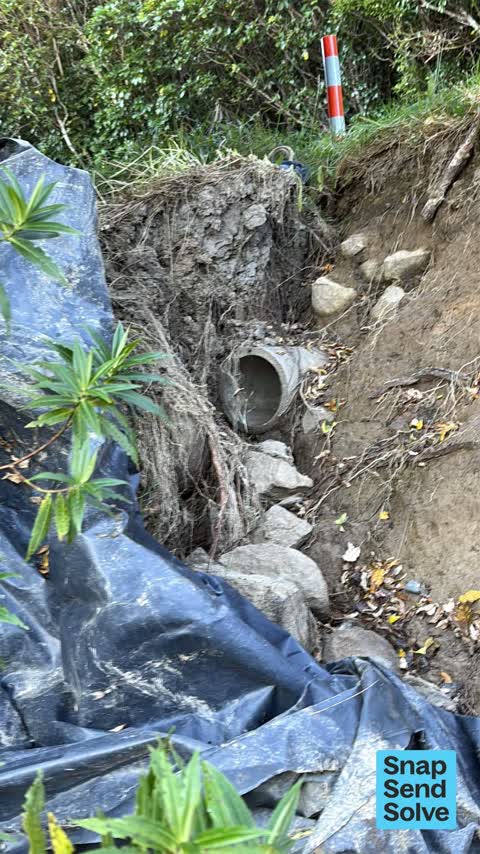
Washout by Summit Road: grade roadside ditch to gully drain to culvert pipe (gravel has blocked the flow of stormwater); re-attach green plastic ‘sock’ to stub…

Rubbish dumped by hall door we have an event here this weekend and this is not nice to look at


Bins of rubbish been there for many years now rusted but people still add rubbish to them


Zoned for Aidanfield Christian School · Christchurch Adventist School · Middleton Grange School · St Thomas of Canterbury College · Villa Maria College · Cashmere High School (part) · and 3 more zones, the drawn zone is indicative; the Ministry’s written scheme is the legal boundary.
Parks and reserves in the council’s open data, a park lands in the suburb its centre falls inside. The whole roll is at /parks.
The February 2011 survey drew mapped ground failure over 0.8% of this outline, about 25 hectares. A patch is a footprint, not a finding about an address; the count for the whole city is at /liquefaction.
The rockfall survey mapped 6 rocks inside this outline across 2 survey pins. A pin may stand for a cluster and marks where the survey saw the rock, not where it is now; the whole survey is drawn at /boulders.
The council’s structure register stands 1 asset on this ground, 1 boardwalk, sited at Coopers Knob. The register’s site names are its own labels for the ground an asset stands in; the layer is drawn at the map.
The plan’s schedule of sites significant to Ngāi Tahu covers 0% of this outline, about 12 hectares, ngā tūranga tūpuna. Shares read from a sampled join; a recognition overlay, not a catalogue. The whole schedule is drawn at /cultural.
The plan’s water-margin layers cross this outline, 1 classified reach, the plan calling Halswell River by name. The margin is the plan’s drawing, not a survey of the bank; the reaches, strips and held edges are mapped at /water-margin.
The outline sits inside the takiwā of Rapaki Runanga and Te Ngai Tuahuriri Runanga. The bylaw is the instrument, this the map of it, the whole rulebook is drawn at /rules.
GeoNet’s catalogue puts 1 magnitude-3+ epicentre inside this outline since the sequence opened, the biggest a M3.6 in 2010. An epicentre is where the instruments placed the break, not a measure of the shaking here; the whole catalogue is counted at /sequence, the live record is /quakes, and the story in plain language is the earthquakes explainer.
The named waterways, bays, headlands, monuments, summits and old sites OpenStreetMap puts inside this outline, a pin is the mapper’s own; a waterway belongs to every suburb it crosses. Every roll, counted: /geography.
3 premises in Tai Tapu across 3 kinds, from OpenStreetMap, the council’s licensed-premises register and its 2024 Find Christchurch directory. Each kind below opens at this suburb’s shelf.
What the archive’s sources say about Tai Tapu, titled for it, turned up by a search for one of its places, or carrying its name in the text. These are leads and citations: the originals live at the provider, linked from each row.
…bbie bay 6 1492 2 2 0 500 charteris bay 7 1587 9 0 0 18 0 0 prebbleton 8 1595 1 0 0 2 0 0 tai tapu 2 1596 5 ofo 10 0 0 rangipra 10 1621 12 0 0 2 0 0 avonside 11 1656 4 0 0 8 0 0 government buildings c…Lyttelton Times · Papers Past · National Library of New Zealand · · text held
The rest are a search away, the whole shelf, for the name →
189 more documents came up in searches for Tai Tapu's places and have not been read yet, a lead is a search result, not a fact, until somebody reads it.
Compare Tai Tapu with Gebbies Valley · Ataahua · Charteris Bay · Governors Bay · Te Rapaki o Te Rakiwhakaputa · Rapaki, same record, side by side.
Tai Tapu, previously known as Taitapu, is a small town adjacent to the Halswell River and nestled in the Port Hills, located 6 km east of the town of Lincoln and 18 km south west of Christchurch in the Canterbury region of New Zealand's South Island. The public record holds 56 council reports for it, the first filed in March 2022.
1,360 people at the 2023 Census, 42 per square kilometre across 33 km².
56 reports on record, most often everything else (29), roads & footpaths (10), trees & parks (7). 22 of them in the year to 12 October 2026.
GeoNet’s catalogue puts 1 magnitude-3+ epicentre inside the suburb’s mapped outline since the September 2010 mainshock, the biggest a M3.6 in 2010. An epicentre is where the instruments placed the break, not a measure of the shaking felt here. The whole sequence, counted → · The story, in plain language →
The heritage register holds 13 places here, Ellesmere Arms, Former Governors Bay Lock-up among them. The written record goes back further: the shelf, for the name →
Every suburb in Christchurch → · Its decade, charted → · the whole A–Z →
Work orders, not the resident reports above, the council’s MyCouncilTicket stream, and one job can appear in both. A median counts only finished jobs; open ones are named as open, never averaged in. The ticket roll · the whole city’s fix times.
The council’s bylaw zones and the Local Alcohol Policy’s buffer list, read from the Regulatory open-data service. A ban rules drinking in public places; it says nothing about whether a premises may sell, that is the licence register’s job.
Ministry of Education directory, the final decile and the current Equity Index describe the community a school draws from, not how well it teaches. Zones are indicative; the written enrolment scheme rules.
Parks and reserves in the council’s open data, the park lands in the suburb its centre falls inside; one that straddles the line keeps its own address.
Libraries, halls, cemeteries and the rest in the council’s open data, a facility lands in the suburb its point or centre falls inside.
Places of worship in the open map’s record, one lands in the suburb its building stands in. The whole roll is at /worship.
Marae in the region’s roll, a marae stands where it stands; the join names the suburb the roll files it under. The whole roll is at /maraes.
Walking, biking, horse and off-road tracks in the council’s open data, a line belongs to every suburb it passes through.
OpenStreetMap’s own record, inside this outline, a pin is the mapper’s; a waterway belongs to every suburb it crosses. Every roll, counted: /geography.
Heritage places the council’s district plan or Heritage New Zealand list inside this suburb, each with what is known about it and the document it is known from.
The register’s era records for places in this suburb, what stood on the ground, and when.
Each of these is a decade of reports, the heritage places on the register, what is known about them, and the documents behind it, everything the archive holds about the part of the city it names.