229 Kilmore Street, Christchurch Central City
28 reports on record since December 2015 · 18 with photographs. The street’s heaviest record is 70 Kilmore Street — 86 reports on file. Indicative rating valuation and school zones, hazards, bin day and what stood here before.
What gets reported here
Photographed here 18 on record


Reported here
 Graffiti on a traffic light pole or cabinet, or wa —
 graffiti on traffic control cabinet
 Graffiti on a traffic light pole or cabinet, or wa —
  Graffiti on a traffic light pole or cabinet, or wa —
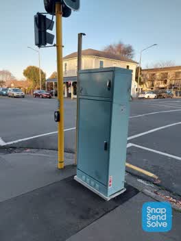
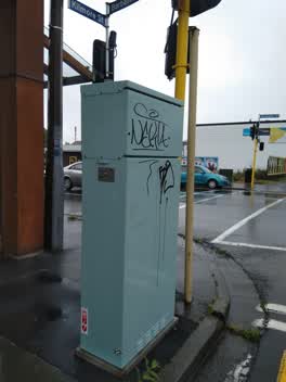
 Black paint tag on traffic controller at 229 Kilmore Street.
 Graffiti on a cabinet, pole or railway asset —
 Graffiti on pale blue cabinet
 Graffiti on a cabinet, pole or railway asset —
 Every single traffic signal cabinet in the city appears to be tagged as in all of them
 Graffiti on a cabinet, pole or railway asset —
 Multiple paint tags on traffic controller at 229 Kilmore Street corner of Barbadoes Street.
 Graffiti on a cabinet, pole or railway asset —
  Graffiti on a fence, building or structure —
  Graffiti on a cabinet, pole or railway asset —
 Black and yellow paint tags on 3 sides of ATSC4 traffic controller at the corner of Kilmore and Barbadoes Streets.
 Graffiti somewhere else —
 Every traffic light cabinet from cnr Avonside Dr/stanmore rd and all along Kilmore St to at least Columbo is heavily graffiti ed. It would b
 Graffiti somewhere else —
 - Graffiti —
- Graffiti —
- Graffiti —
- General Request —
- Pavement - Damaged —
- Graffiti —
- Graffiti —
- Water Leak —
- Water Leak —
- Water Leak —
 Graffiti —
  Graffiti —
 Yellow paint tag on Piko wall facing the footpath on Barbadoes Street corner of Kilmore Street.
 Graffiti —
 KAEPE stickers on ATC box at intersection of Kilmore and Barbadoes KAEPE is combined with KP on the sticker - may be same person doing KP an
 Graffiti —
 Roading/Streets —
Graffiti —
Power role
Graffiti —
Also reported on Kilmore Street
- 70 Kilmore Street — 86 reports
- 211 Kilmore Street — 72 reports
- 294E Kilmore Street — 53 reports
- 277 Kilmore Street — 49 reports
- 254 Kilmore Street — 42 reports
- 86 Kilmore Street — 30 reports
- 284 Kilmore Street — 29 reports
- 296 Kilmore Street — 27 reports
The street’s crash record
NZTA’s record names Kilmore Street in 104 crashes that hurt somebody since 2006 — 1 person killed, 22 seriously hurt.
The green nearby
- Avon Riverbank Central City — 136 m to the edge · 6 ha
- Cambridge Green — 158 m to the edge
- Fire Fighters Reserve — 164 m to the edge
- Chester Street East Reserve — 202 m to the edge
- Cambridge Reserve — 242 m to the edge
Parks within half a kilometre, measured to the boundary — the council’s open data.
On the doorstep
- Piko Wholefoods — 3 m away · Delis
- Piko Whole Foods — 15 m away · Dairies & convenience
- The Herb Centre Cafe — 24 m away · Cafés
- Make Collective — 30 m away · Business
Businesses within four hundred metres, measured at the pin — OpenStreetMap and the council directories.
The bus nearby
- Gloucester St near Barbadoes St — 371 m away · route 5, route 7
- Gloucester St near Barbadoes St — 391 m away · route 5, route 7
The closest Metro stops, within four hundred and fifty metres.
The tracks through here
- Walk and bike track through Christchurch Central City — 11 m to the line · walk · bike
- Walk and bike track through Christchurch Central City — 75 m to the line · walk · bike
- Walk and bike track through Christchurch Central City — 122 m to the line · walk · bike
- Walk and bike track through Christchurch Central City — 137 m to the line · walk · bike
- Walk and bike track through Christchurch Central City — 191 m to the line · walk · bike
Tracks whose line passes within half a kilometre, measured to the line itself — the council’s open data.
The named ground
Named water within 500 m of this address, measured to the line or the edge; Named places within 1.5 km of this address; the council’s own structure register — bridges, boardwalks and steps standing nearby — the open map’s record.
The remembered names nearby
- Plaque no. 310899 — 94 m away
- Plaque no. 310900 — 94 m away
- Plaque no. 310901 — 94 m away
Inscribed plaques within two hundred and fifty metres — the register’s pins, not surveyed spots. The whole roll is at /plaques.
Renting nearby
new bonds in Christchurch Central City ran about $508 a week — $42 below the city median of $550 — the suburb page keeps the rent record →.
What was here — Commercial Building and Setting
37 m away · 228 Kilmore Street · located to ±11 m · the place’s own record →
On the register. Nothing researched here yet.
What was here — The Bricks Site, Cairn and Setting
112 m away · 311 Oxford Terrace · located to ±35 m · the place’s own record →
On the register. Nothing researched here yet.
What was here — Dwelling and Setting
155 m away · 250 Kilmore Street · located to ±8 m · the place’s own record →
On the register. Nothing researched here yet.
What was here — Dwellings and Setting
231 m away · 100 Chester Street East · located to ±13 m · the place’s own record →
On the register. Nothing researched here yet.
The civic layer
This ground votes in Central ward — the Papanui-Innes-Central community board. Ward lines don’t always follow suburb lines; this one is measured at the pin, not the suburb’s centre.
What stood on this ground → · On the map → · From the air — the Crown’s aerials back to 1936; search the address on RetroLens →
Questions, answered briefly
28 council reports on record since December 2015 — most often graffiti (11), graffiti on a cabinet, pole or railway asset (5), water leak (3).
Christchurch Central City, Christchurch — on Kilmore Street.
The heritage register names 4 places at or beside it — Commercial Building and Setting, The Bricks Site, Cairn and Setting.
Avon Riverbank Central City — 136 m to its edge, 6 ha.