70 Kilmore Street, Christchurch Central City
86 reports on record since January 2018 · 65 with photographs. The most-reported address on Kilmore Street. Indicative rating valuation and school zones, hazards, bin day and what stood here before.
What gets reported here
Photographed here 65 on record


Reported here the newest 80 of 86
 Graffiti on a fence, building or structure —
  Trees - General —
 Tree pushed over exposing roots
 Graffiti on a fence, building or structure —
  Graffiti on a fence, building or structure —
  Hazard — vehicle —
 Shocking parking. Blocked others in.
 Graffiti on a fence, building or structure —
  Graffiti on a sign, mural or public art —
 Tagging on welcome to Christchurch sign
 Litter —
 broken glass on footpath
 Road Signage —
 No entry sign facing wrong way
 Graffiti on a fence, building or structure —
 ET crimson paint tag on steel floodlight pole by 70 Kilmore Street.
 Graffiti on a sign, mural or public art —
 Exiting Victoria square. Info sign
 Park - General Request —
 The light closest to the intersection has been flickering for a couple of weeks.
 Graffiti on a fence, building or structure —
  Graffiti on a fence, building or structure —
  General Request —
 Large umbrella has been bent up by winds at the commons by vic square
 Graffiti on a fence, building or structure —
 On map by town hall…Victoria st side
 Graffiti on a fence, building or structure —
  Graffiti on a fence, building or structure —
  Hazard — vehicle —
 Who manages/owns the area called The Commons? It is being used as a free carpark. Cars even park on the grass. There are no 'no parking' si
 Graffiti on a sign, mural or public art —
  Graffiti on a sign, mural or public art —
  Park - General Request —
 Why is the umbrella over the stones? When the grass area is on the direct sun, can’t really sit on stones
 Graffiti somewhere else —
  Graffiti somewhere else —
  Graffiti on a sign, mural or public art —
  Graffiti on a playground or in a park —
 Victoria square
 Graffiti somewhere else —
  Graffiti somewhere else —
  Graffiti somewhere else —
 Have added pics where it's near
 Graffiti somewhere else —
 On wooden arches Victoria Street Kilmore Street
 Graffiti somewhere else —
  Graffiti on a playground or in a park —
 On otautahi map
 Graffiti on a fence, building or structure —
  Graffiti on a fence, building or structure —
  Water Leak —
 Drinking water station experiencing spontaneous uncontrolled discharge
 Graffiti on a sign, mural or public art —
  Poles and Signage - General —
 20m south of kilmore st on eastern side by motorbike parking. Missing pole and trip hazard, namely me! Urgent.
 Graffiti on a fence, building or structure —
  Road Signage —
 Sound when u can cross the road on poll 6 is not working. Contact Traffic control Systems limited - Sparks to fix
 Vandalism - General —
 Green Toby lid smashed causing trip hazard in footpath by crown royal plaza, currently has cone over it
 Dumped Rubbish —
 A lot of broken glass
 Pavement - General —
 Sharp shards of broken glass right across the footpath.
 Graffiti on a fence, building or structure —
  Graffiti on a fence, building or structure —
 yellow and blue graffiti on structure
 Graffiti on a fence, building or structure —
 graffiti all over shipping container
 Graffiti on a fence, building or structure —
 white graffiti on maroon ground
- Facility - General Request —
People are sleeping here overnight. Quite a number of homeless people gather here. It is a main thoroughfare for residents in the Victoria S
- Hazard — vehicle —
- Accessibility —
- Graffiti —
- Graffiti —
- Graffiti —
- Graffiti —
- Graffiti —
- Graffiti —
- Graffiti —
- Graffiti —
- Graffiti —
- Graffiti —
- Damaged Street Sign —
- Graffiti —
- Graffiti —
- Graffiti —
- Vandalism - General —
 Vandalism - General —
 Piece missing plus graffiti
 Litter —
 Glass
 Vandalism - General —
 Slider missing and graffiti
 Vandalism - General —
 Rubbish left behind
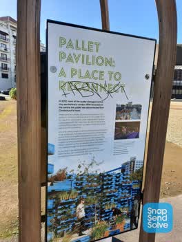 Graffiti —
 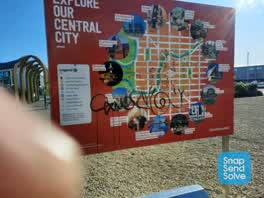 Graffiti —
 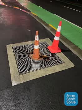 Roading/Streets —
 There is a damage grate/tree surround that needs to be made safe. A patron left an event at the town hall this evening and tripped on this,
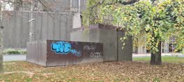 Graffiti —
  Graffiti —
 Anti vax misinformation sticky tag on steel lamp pole on the corner of Kilmore and Durham Street North needs removal.
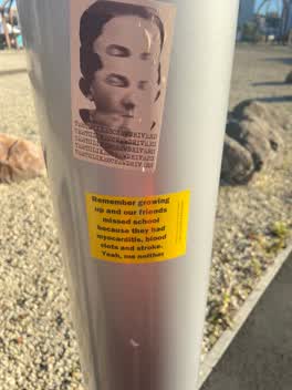 Graffiti —
 Anti vax misinformation sticky tag on steel lamp pole on Kilmore Street west from the town hall needs removal.
- Parks —
Piece missing
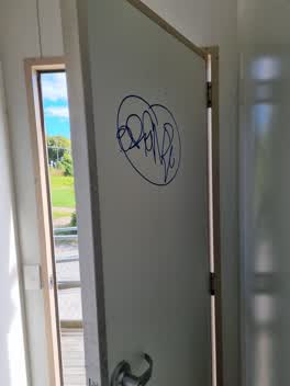 Graffiti —
 Toilet with ipen door next to The Commons and Wimsons Carpark
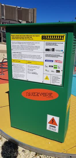 Parks —
 We've seen this Gap Filler project in two locations now, and it's never ever worked!
- Roading/Streets —
push button of the crossing at north kilmore is missing
Graffiti —
Wastewater/Stormwater —
hi, you can hear that water is flowing under this green box, weather a tap is cot closed or something is broken, who knows. there is also a
6 more on record — the live page pages them.
Also reported on Kilmore Street
- 211 Kilmore Street — 72 reports
- 294E Kilmore Street — 53 reports
- 277 Kilmore Street — 49 reports
- 254 Kilmore Street — 42 reports
- 86 Kilmore Street — 30 reports
- 284 Kilmore Street — 29 reports
- 229 Kilmore Street — 28 reports
- 296 Kilmore Street — 27 reports
The street’s crash record
NZTA’s record names Kilmore Street in 104 crashes that hurt somebody since 2006 — 1 person killed, 22 seriously hurt.
The green nearby
- Victoria Square — 139 m to the edge · Botanic · 2 ha
- Victoria Triangles — 171 m to the edge
- Canterbury Provincial Council Reserve — 208 m to the edge · Botanic
- Cranmer Square — 238 m to the edge · Botanic · 2 ha
- Edmonds Band Rotunda — 338 m to the edge · Botanic
Parks within half a kilometre, measured to the boundary — the council’s open data.
The civic shelf nearby
- Aldersgate — 131 m away · Car park
- Armagh St — 191 m away · Car park
- Turanga Library — 432 m away · Library · Cathedral Square, Christchurch
Libraries, halls and the rest within half a kilometre — the council’s open data.
On the doorstep
- Mobile Osaka-ya — 25 m away · Fast food
- The Dukes of Sandwich Food Truck — 27 m away · Fast food
- Cafe Miha Food Caravan — 30 m away · Fast food
- Laneway Espresso — 56 m away · Cafés
Businesses within four hundred metres, measured at the pin — OpenStreetMap and the council directories.
The bus nearby
- Kilmore Street Town Hall — 94 m away · route 1, route 29, route 95
- Victoria St near Peterborough St — 284 m away · route 1, route 29, route 95
The closest Metro stops, within four hundred and fifty metres.
The tracks through here
- Walk and bike track through Christchurch Central City — 56 m to the line · walk · bike
- Walk and bike track through Christchurch Central City — 199 m to the line · walk · bike
- Walk and bike track through Christchurch Central City — 215 m to the line · walk · bike
- Walk and bike track through Christchurch Central City — 288 m to the line · walk · bike
- Walk and bike track through Christchurch Central City — 340 m to the line · walk · bike
Tracks whose line passes within half a kilometre, measured to the line itself — the council’s open data.
The named ground
Named water within 500 m of this address, measured to the line or the edge; Named places within 1.5 km of this address; the council’s own structure register — bridges, boardwalks and steps standing nearby — the open map’s record.
The remembered names nearby
- In Conjunction With the Christchurch Beautifying — 86 m away ·
IN CONJUNCTION WITH THE CHRISTCHURCH BEAUTIFYING ASSOCIATION INC. THIS FLORAL CLOCK WAS PR
· 2009 - This Floral Clock Was Presented to the Citizens — 86 m away ·
THIS FLORAL CLOCK WAS PRESENTED TO THE CITIZENS OF CHRISTCHURCH BY CALDER MACKAY CO. LTD 1
· 2009 - The Hamish Hay Bridge — 139 m away ·
THE HAMISH HAY BRIDGE / This historic bridge was renamed by the Christchurch City Council
· 2018
Inscribed plaques within two hundred and fifty metres — the register’s pins, not surveyed spots. The whole roll is at /plaques.
Renting nearby
new bonds in Christchurch Central City ran about $508 a week — $42 below the city median of $550 — the suburb page keeps the rent record →.
What was here — Floral Clock and Setting
87 m away · 66 Chester Street West · located to ±5 m · the place’s own record →
On the register. Nothing researched here yet.
What was here — The Christchurch Town Hall and Setting
126 m away · located to ±79 m · the place’s own record →
On the register. Nothing researched here yet.
What was here — Former Market Place Bridge/Hamish Hay Bridge and Setting
132 m away · located to ±31 m · the place’s own record →
On the register. Nothing researched here yet.
What was here — Captain James Cook Statue and Setting
169 m away · 89 Armagh Street · located to ±2 m · the place’s own record →
On the register. Nothing researched here yet.
What was here — Former Magistrates Court and Setting
171 m away · 85 Armagh Street · located to ±21 m · the place’s own record →
On the register. Nothing researched here yet.
The civic layer
This ground votes in Central ward — the Papanui-Innes-Central community board. Ward lines don’t always follow suburb lines; this one is measured at the pin, not the suburb’s centre.
What stood on this ground → · On the map → · From the air — the Crown’s aerials back to 1936; search the address on RetroLens →
Questions, answered briefly
86 council reports on record since January 2018 — most often graffiti (21), graffiti on a fence, building or structure (17), graffiti somewhere else (7).
Christchurch Central City, Christchurch — on Kilmore Street.
The heritage register names 5 places at or beside it — Floral Clock and Setting, The Christchurch Town Hall and Setting.
Victoria Square — 139 m to its edge, 2 ha.