277 Kilmore Street, Christchurch Central City
49 reports on record since January 2020 · 42 with photographs. The street’s heaviest record is 70 Kilmore Street — 86 reports on file. Indicative rating valuation and school zones, hazards, bin day and what stood here before.
What gets reported here
Photographed here 42 on record


Reported here
 Graffiti somewhere else —
On corner
 Graffiti somewhere else —
 Graffiti on a cabinet, pole or railway asset —
Graffiti on cabinet
 Graffiti on a fence, building or structure —
 Graffiti on a cabinet, pole or railway asset —
White, silver and brown paint tags on Enable asset CN850 at the corner of Bangor and Kilmore Streets.
 Graffiti somewhere else —
 Graffiti somewhere else —
 Graffiti on a cabinet, pole or railway asset —
 Graffiti somewhere else —
 Graffiti on a fence, building or structure —
 Graffiti somewhere else —
 Graffiti somewhere else —
 Graffiti somewhere else —
 Graffiti somewhere else —
 Graffiti somewhere else —
 Graffiti somewhere else —
 Park - General Request —
Hi. Just wondering when some planting will be done in this berm. The attractive flax bushes were removed last year but nothing has replaced
 Graffiti somewhere else —
 Graffiti on a cabinet, pole or railway asset —
 Graffiti somewhere else —
 Graffiti somewhere else —
 Graffiti on a cabinet, pole or railway asset —
Graffiti on Enable box still unresolved
 Graffiti on a cabinet, pole or railway asset —
Graffiti on green cabinet outside 277 Kilmore st. This was first reported on 6 June and hasn’t been resolved
 Graffiti somewhere else —
 Graffiti on a cabinet, pole or railway asset —
 Graffiti on a cabinet, pole or railway asset —
 Graffiti somewhere else —
 Graffiti somewhere else —
 Graffiti on a sign, mural or public art —
Black paint tag on reverse side of sign by 277 Kilmore Street.
 Graffiti on a cabinet, pole or railway asset —
Red and white paint tags on CN852 asset by 277 Kilmore Street.
 Flooding —
The northern side of Kilmore st near the corner with Bangor st. Unfortunately this spot has been flooding since we moved here in 2015. The d
 Graffiti —
 Graffiti —
 Graffiti —
 Graffiti —
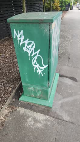
White lettering graffiti on a green box. Corner of Bangor St and Kilmore St. CN850.
 Graffiti —
 Graffiti —
 Graffiti —
 Flooding —
- Street Gutters / Storm Water —
- Graffiti —
- Street Gutters / Storm Water —
- Graffiti —
- Vandalism - General —
- Street Gutters / Storm Water —
- Hazard — vehicle —
 Graffiti —
 General Request —
Cnr kilmore and bangor
Roading/Streets —
Mail thrown in bushes
Also reported on Kilmore Street
- 70 Kilmore Street — 86 reports
- 211 Kilmore Street — 72 reports
- 294E Kilmore Street — 53 reports
- 254 Kilmore Street — 42 reports
- 86 Kilmore Street — 30 reports
- 284 Kilmore Street — 29 reports
- 229 Kilmore Street — 28 reports
- 296 Kilmore Street — 27 reports
The street’s crash record
NZTA’s record names Kilmore Street in 104 crashes that hurt somebody since 2006 — 1 person killed, 22 seriously hurt.
The green nearby
- Avon Riverbank Central City — 96 m to the edge · 6 ha
- Walnut Tree Park — 127 m to the edge
- Chester Street East Reserve — 168 m to the edge
- William Brittan — 171 m to the edge
- Cambridge Green — 267 m to the edge
Parks within half a kilometre, measured to the boundary — the council’s open data.
On the doorstep
- Pomeroy's on Kilmore — 70 m away · Guest houses
- Beer Baroness Brewing Company — 80 m away · Bottle stores
- Catalyst — 84 m away · IT & software
- Little Pom's — 85 m away · Restaurants
Businesses within four hundred metres, measured at the pin — OpenStreetMap and the council directories.
The bus nearby
- Fitzgerald Ave near River Rd — 199 m away · route 7
- Fitzgerald Ave near Avonside Dr — 215 m away · route 7
The closest Metro stops, within four hundred and fifty metres.
The tracks through here
- Walk and bike track through Christchurch Central City — 14 m to the line · walk · bike
- Walk and bike track through Christchurch Central City — 150 m to the line · walk · bike
- Walk and bike track through Christchurch Central City — 150 m to the line · walk · bike
- Walk and bike track through Christchurch Central City — 150 m to the line · walk · bike
- Walk and bike track through Christchurch Central City — 257 m to the line · walk · bike
Tracks whose line passes within half a kilometre, measured to the line itself — the council’s open data.
The named ground
Named water within 500 m of this address, measured to the line or the edge; Named places within 1.5 km of this address; the council’s own structure register — bridges, boardwalks and steps standing nearby — the open map’s record.
The remembered names nearby
- William Guise Brittan Historical Garden on 26 November 1994 — 172 m away ·
WILLIAM GUISE BRITTAN HISTORICAL GARDEN On 26 November 1994 the first shrubs were planted
· 2009 - He Tohu Whakamaumahara o Matou Tipuna — 200 m away ·
He tohu whakamaumahara o matou tipuna
· 2009
Inscribed plaques within two hundred and fifty metres — the register’s pins, not surveyed spots. The whole roll is at /plaques.
Renting nearby
new bonds in Christchurch Central City ran about $508 a week — $42 below the city median of $550 — the suburb page keeps the rent record →.
What was here — Former Maturing Cellars and Administration Offices and Setting
98 m away · 294 Kilmore Street · located to ±24 m · the place’s own record →
On the register. Nothing researched here yet.
What was here — Dwelling and Setting
112 m away · 250 Kilmore Street · located to ±8 m · the place’s own record →
On the register. Nothing researched here yet.
What was here — Former Boiler House and Setting
144 m away · 175 Chester Street East · located to ±10 m · the place’s own record →
On the register. Nothing researched here yet.
What was here — Dwelling and Setting, Englefield
205 m away · 230 Fitzgerald Avenue · located to ±14 m · the place’s own record →
On the register. Nothing researched here yet.
What was here — Commercial Building and Setting
234 m away · 228 Kilmore Street · located to ±11 m · the place’s own record →
On the register. Nothing researched here yet.
The civic layer
This ground votes in Central ward — the Papanui-Innes-Central community board. Ward lines don’t always follow suburb lines; this one is measured at the pin, not the suburb’s centre.
What stood on this ground → · On the map → · From the air — the Crown’s aerials back to 1936; search the address on RetroLens →
Questions, answered briefly
49 council reports on record since January 2020 — most often graffiti somewhere else (17), graffiti (10), graffiti on a cabinet, pole or railway asset (9).
Christchurch Central City, Christchurch — on Kilmore Street.
The heritage register names 5 places at or beside it — Former Maturing Cellars and Administration Offices and Setting, Dwelling and Setting.
Avon Riverbank Central City — 96 m to its edge, 6 ha.