51 Peterborough Street, Christchurch Central City
16 reports on record since January 2019 · 11 with photographs. The street’s heaviest record is 152 Peterborough Street — 35 reports on file. Indicative rating valuation and school zones, hazards, bin day and what stood here before.
What gets reported here
Photographed here 11 on record


Reported here
 Graffiti on a traffic light pole or cabinet, or wa —
 White paint tag on metal plate on concrete lamp pole by 51 Peterborough Street.
 Graffiti on a traffic light pole or cabinet, or wa —
 White paint tag on metal plate on concrete lamp pole by 51 Peterborough Street.
 Rubbish and Bins - General —
 Recycling wheelie bin belonging to either 63 or 83 Bealey ave currently full sitting on Peterborough street near The Bog
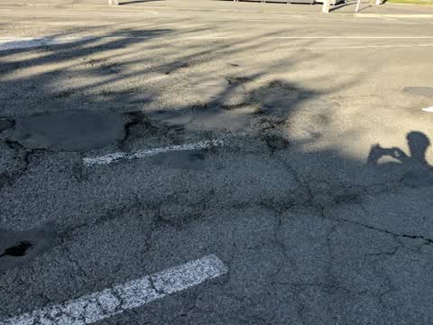
 Pothole —
 The whole section of Peterborough St in between Victoria St & Durham St North is in terrible condition, with numerous potholes that are gett
 Damaged Road —
 Looks like this was marked out for repair but never completed. Terrible road surface
 Water Leak —
 Water pipe seems to have burst, garden bed flooded and running out into footpath.
- Damaged Road —
Can the section of Peterborough St directly behind the Casino please be completely reseated multiple large potholes between Victoria St & Du
 Graffiti on a fence, building or structure —
 EKOE white paint tag on metal plate on concrete lamp pole by 51 Peterborough Street.
 Hazard — vehicle —
 Broken glass in Mobility park
 Fallen Tree —
 Tree falling over, probably needs staking or to be replaced
- Water Leak —
- Street Gutters / Storm Water —
- Street Gutters / Storm Water —
- Damaged Road —
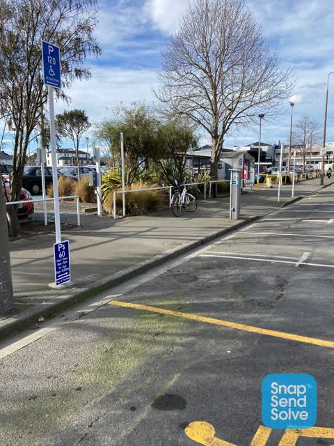
 Road Signage —
 Please reposition P$60 sign on white post so as it’s underneath the P120 Mobility sign. On North side Peterborough outside casino car park.
Roading/Streets —
I challenge any roading staff to safely ride a bike through this intersection while indicating & checking left & right for traffic. Shocking
Also reported on Peterborough Street
- 152 Peterborough Street — 35 reports
- 11 Peterborough Street — 26 reports
- 170 Peterborough Street — 22 reports
- 76 Peterborough Street — 15 reports
- 25 Peterborough Street — 14 reports
- 181 Peterborough Street — 14 reports
- 52 Peterborough Street — 13 reports
- 39 Peterborough Street — 13 reports
The street’s crash record
NZTA’s record names Peterborough Street in 47 crashes that hurt somebody since 2006 — 12 seriously hurt, nobody killed.
The green nearby
- Victoria Triangles — 14 m to the edge
- Cranmer Square — 182 m to the edge · Botanic · 2 ha
- Aldred Reserve — 199 m to the edge
- Victoria Square — 344 m to the edge · Botanic · 2 ha
- Canterbury Provincial Council Reserve — 390 m to the edge · Botanic
Parks within half a kilometre, measured to the boundary — the council’s open data.
The civic shelf nearby
- Aldersgate — 287 m away · Car park
- Armagh St — 336 m away · Car park
Libraries, halls and the rest within half a kilometre — the council’s open data.
On the doorstep
- The Bog — 42 m away · Bars & pubs
- Monza Sports Bar - Christchurch Casino — 43 m away · Bars & pubs
- The Bog Irish Bar — 45 m away · Restaurants
- 71st Cafe & Bar — 47 m away · Restaurants
Businesses within four hundred metres, measured at the pin — OpenStreetMap and the council directories.
The bus nearby
- Victoria St near Peterborough St — 86 m away · route 1, route 29, route 95
- Salisbury St near Victoria St — 148 m away · route 1, route 29, route 95
The closest Metro stops, within four hundred and fifty metres.
The tracks through here
- Walk and bike track through Christchurch Central City — 30 m to the line · walk · bike
- Walk and bike track through Christchurch Central City — 120 m to the line · walk · bike
- Walk and bike track through Christchurch Central City — 356 m to the line · walk · bike
- Walk and bike track through Christchurch Central City — 369 m to the line · walk · bike
- Walk and bike track through Christchurch Central City — 369 m to the line · walk · bike
Tracks whose line passes within half a kilometre, measured to the line itself — the council’s open data.
The named ground
Named water within 500 m of this address, measured to the line or the edge; Named places within 1.5 km of this address; the council’s own structure register — bridges, boardwalks and steps standing nearby — the open map’s record.
The remembered names nearby
- Victoria Triangles plaque — 163 m away · 2014
- Victoria Triangles plaque — 164 m away · 2009
- Diamondjubilee / 1837 - 1897 — 165 m away ·
DiamondJubilee / 1837 - 1897
· 2009
Inscribed plaques within two hundred and fifty metres — the register’s pins, not surveyed spots. The whole roll is at /plaques.
Renting nearby
new bonds in Christchurch Central City ran about $508 a week — $42 below the city median of $550 — the suburb page keeps the rent record →.
What was here — Victoria Mansions and Setting
149 m away · F/91 Victoria Street · located to ±21 m · the place’s own record →
On the register. Nothing researched here yet.
What was here — Jubilee Clock Tower and Setting
167 m away · 95 Victoria Street · located to ±5 m · the place’s own record →
On the register. Nothing researched here yet.
What was here — Former Shop/Dwelling and Setting
170 m away · 40 Cranmer Square · located to ±6 m · the place’s own record →
On the register. Nothing researched here yet.
What was here — Dwelling and Setting
181 m away · 38 Cranmer Square · located to ±5 m · the place’s own record →
On the register. Nothing researched here yet.
What was here — Dwelling and Setting, Ironside House
201 m away · 32 Salisbury Street · located to ±15 m · the place’s own record →
On the register. Nothing researched here yet.
The civic layer
This ground votes in Central ward — the Papanui-Innes-Central community board. Ward lines don’t always follow suburb lines; this one is measured at the pin, not the suburb’s centre.
What stood on this ground → · On the map → · From the air — the Crown’s aerials back to 1936; search the address on RetroLens →
Questions, answered briefly
16 council reports on record since January 2019 — most often damaged road (3), water leak (2), street gutters / storm water (2).
Christchurch Central City, Christchurch — on Peterborough Street.
The heritage register names 5 places at or beside it — Victoria Mansions and Setting, Jubilee Clock Tower and Setting.
Victoria Triangles — 14 m to its edge.