76 Peterborough Street, Christchurch Central City
15 reports on record since July 2022 · 11 with photographs. The street’s heaviest record is 152 Peterborough Street — 35 reports on file. Indicative rating valuation and school zones, hazards, bin day and what stood here before.
What gets reported here
Photographed here 11 on record


Reported here
 Hazard — vehicle —
 car parked in motorcycle park, has been happening more frequently. makes it hard to turn out of our property!
 Graffiti on a traffic light pole or cabinet, or wa —
 Graffiti and trolley
 Trees - General —
 There is no tree planted on this Council owned garden. Please get one planted in it, rather than leaving it missing for another 15 years.
 Graffiti somewhere else —
  Graffiti on a fence, building or structure —
  Graffiti on a fence, building or structure —
  Road Signage —
 Road sign needs reorientation; vandals? By 76 Peterborough Street.
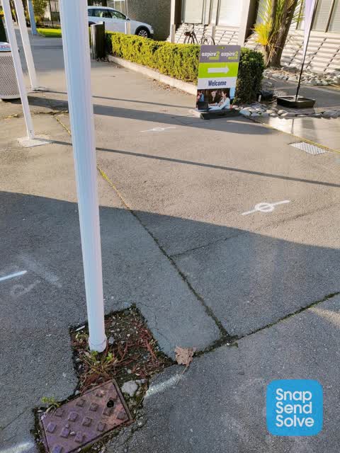
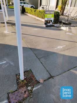
 Pavement - Damaged —
 Toby lid needs replacing properly. Beyond my 85 year old self to do it!
- Graffiti —
- Water Leak —
- Water Leak —
- Graffiti —
 Graffiti —
 TN black paint tag on garage door post facing the footpath on Peterborough Street a tad east of Durham Street North.
 Graffiti —
 Red paint tag on steel rubbish bin lid by 76 Peterborough Street.
 Roading/Streets —
Also reported on Peterborough Street
- 152 Peterborough Street — 35 reports
- 11 Peterborough Street — 26 reports
- 170 Peterborough Street — 22 reports
- 51 Peterborough Street — 16 reports
- 25 Peterborough Street — 14 reports
- 181 Peterborough Street — 14 reports
- 52 Peterborough Street — 13 reports
- 39 Peterborough Street — 13 reports
The street’s crash record
NZTA’s record names Peterborough Street in 47 crashes that hurt somebody since 2006 — 12 seriously hurt, nobody killed.
The green nearby
- Victoria Triangles — 105 m to the edge
- Aldred Reserve — 194 m to the edge
- Cranmer Square — 263 m to the edge · Botanic · 2 ha
- Victoria Square — 267 m to the edge · Botanic · 2 ha
- Rose Historic Chapel Reserve — 334 m to the edge · Botanic
Parks within half a kilometre, measured to the boundary — the council’s open data.
The civic shelf nearby
- Aldersgate — 274 m away · Car park
- Armagh St — 331 m away · Car park
Libraries, halls and the rest within half a kilometre — the council’s open data.
On the doorstep
- Christchurch Casino — 82 m away · Attractions
- Focus Motels and Executive Suites — 82 m away · Motels
- Skylark Bar & Lounge - Christchurch Casino — 87 m away · Restaurants
- The Cafe - Christchurch Casino — 97 m away · Restaurants
Businesses within four hundred metres, measured at the pin — OpenStreetMap and the council directories.
The bus nearby
- Kilmore Street Town Hall — 146 m away · route 1, route 29, route 95
- Victoria St near Peterborough St — 201 m away · route 1, route 29, route 95
The closest Metro stops, within four hundred and fifty metres.
The tracks through here
- Walk and bike track through Christchurch Central City — 100 m to the line · walk · bike
- Walk and bike track through Christchurch Central City — 134 m to the line · walk · bike
- Walk and bike track through Christchurch Central City — 353 m to the line · walk · bike
- Walk and bike track through Christchurch Central City — 363 m to the line · walk · bike
- Walk and bike track through Christchurch Central City — 453 m to the line · walk · bike
Tracks whose line passes within half a kilometre, measured to the line itself — the council’s open data.
The named ground
Named water within 500 m of this address, measured to the line or the edge; Named places within 1.5 km of this address; the council’s own structure register — bridges, boardwalks and steps standing nearby — the open map’s record.
The remembered names nearby
- Aldred Reserve plaque — 203 m away ·
ALDRED PARK / IN 1993 A SUGGESTION WAS PUT TO THE CHRISTCHURCH CITY COUNCIL BY THE VICTORI
· 2004 - In Conjunction With the Christchurch Beautifying — 229 m away ·
IN CONJUNCTION WITH THE CHRISTCHURCH BEAUTIFYING ASSOCIATION INC. THIS FLORAL CLOCK WAS PR
· 2009 - This Floral Clock Was Presented to the Citizens — 229 m away ·
THIS FLORAL CLOCK WAS PRESENTED TO THE CITIZENS OF CHRISTCHURCH BY CALDER MACKAY CO. LTD 1
· 2009
Inscribed plaques within two hundred and fifty metres — the register’s pins, not surveyed spots. The whole roll is at /plaques.
Renting nearby
new bonds in Christchurch Central City ran about $508 a week — $42 below the city median of $550 — the suburb page keeps the rent record →.
What was here — The Christchurch Town Hall and Setting
213 m away · located to ±79 m · the place’s own record →
On the register. Nothing researched here yet.
What was here — Floral Clock and Setting
232 m away · 66 Chester Street West · located to ±5 m · the place’s own record →
On the register. Nothing researched here yet.
What was here — Former Shop/Dwelling and Setting
245 m away · 40 Cranmer Square · located to ±6 m · the place’s own record →
On the register. Nothing researched here yet.
The civic layer
This ground votes in Central ward — the Papanui-Innes-Central community board. Ward lines don’t always follow suburb lines; this one is measured at the pin, not the suburb’s centre.
What stood on this ground → · On the map → · From the air — the Crown’s aerials back to 1936; search the address on RetroLens →
Questions, answered briefly
15 council reports on record since July 2022 — most often graffiti (4), water leak (2), graffiti on a fence, building or structure (2).
Christchurch Central City, Christchurch — on Peterborough Street.
The heritage register names 3 places at or beside it — The Christchurch Town Hall and Setting, Floral Clock and Setting.
Victoria Triangles — 105 m to its edge.