152 Peterborough Street, Christchurch Central City
35 reports on record since July 2022 · 27 with photographs. The most-reported address on Peterborough Street. Indicative rating valuation and school zones, hazards, bin day and what stood here before.
What gets reported here
Photographed here 27 on record






Reported here
 Graffiti on a fence, building or structure —
Graffiti on wall
 Rubbish and Bins - General —
 Graffiti on a fence, building or structure —
graffiti on light lamp post pole nearby
 Hazard — vehicle —
This ute has been parked here since the weekend. It is parked up on the footpath. It is blocking pedestrian access for prams, strollers and
 Graffiti on a fence, building or structure —
Graffiti on light lamp post ccc cleans up the graffiti
 Graffiti on a fence, building or structure —
Graffiti on block fence
 Pavement - General —
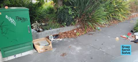
Someones camped here & dimped rubbish
 Dumped Rubbish —
on footpath
 Litter —
rubbish on footpath
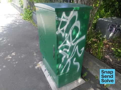
 Graffiti on a cabinet, pole or railway asset —
Graffiti on cabinet
 Graffiti on a cabinet, pole or railway asset —
White, black and silver paint tags on Enable asset CN717 by 152 Peterborough Street.
 Graffiti on a cabinet, pole or railway asset —
Purple paint tag on anonymous metal asset by 152 Peterborough Street.
 Graffiti on a cabinet, pole or railway asset —
ET mauve paint tag on concrete lamp pole by 152 Peterborough Street.
 Graffiti somewhere else —
153 Peterborough St - top and sidesvif green utility box
 Vandalism - General —
 Dumped Rubbish —
 Dumped Rubbish —
Mattress been here a couple of weeks now
 Dumped Rubbish —
Mattress
 Graffiti on a cabinet, pole or railway asset —
Black paint tag on metal plate on concrete lamp pole by 152 Peterborough Street.
 Graffiti on a cabinet, pole or railway asset —
Black paint tag on CN717 asset by 152 Peterborough Street.
 Graffiti on a fence, building or structure —
White paint tags on wooden fence facing the footpath at 152 Peterborough Street.
 Graffiti —
On fence of community garden opposite white townhouses
 Dumped Rubbish —
Single bed and base dumped on side of the footpath, can it please be removed?
 Graffiti —
 Graffiti —
 Hazard — vehicle —
Obstructing footpath
- Graffiti —
- Graffiti —
- Graffiti —
- Graffiti —
- Dumped Rubbish —
- Overgrown Vegetation —
- Overgrown Vegetation —
- Graffiti —
 Dumped Rubbish —
Old plastic bin dumped on the road opposite 145 Peterborough Street needs removal.
Also reported on Peterborough Street
- 11 Peterborough Street — 26 reports
- 170 Peterborough Street — 22 reports
- 51 Peterborough Street — 16 reports
- 76 Peterborough Street — 15 reports
- 25 Peterborough Street — 14 reports
- 181 Peterborough Street — 14 reports
- 52 Peterborough Street — 13 reports
- 39 Peterborough Street — 13 reports
The street’s crash record
NZTA’s record names Peterborough Street in 47 crashes that hurt somebody since 2006 — 12 seriously hurt, nobody killed.
The green nearby
- Edmonds Band Rotunda — 243 m to the edge · Botanic
- Victoria Square — 264 m to the edge · Botanic · 2 ha
- Cambridge Reserve — 267 m to the edge
- Rose Historic Chapel Reserve — 273 m to the edge · Botanic
- Poplars Reserve — 324 m to the edge · Botanic
Parks within half a kilometre, measured to the boundary — the council’s open data.
On the doorstep
- Forte 2 — 93 m away · Doctors & clinics
- Forte Health — 111 m away · Hospital
- Stat Espresso — 112 m away · Cafés
- Urology Associates — 124 m away · Doctors & clinics
Businesses within four hundred metres, measured at the pin — OpenStreetMap and the council directories.
The bus nearby
- Manchester St near Kilmore St — 106 m away · route 1, route 27, route 29, route 44, route 91, route 92, route 95
- Manchester St near Salisbury St — 125 m away · route 1, route 27, route 29, route 44, route 95
The closest Metro stops, within four hundred and fifty metres.
The tracks through here
- Walk and bike track through Christchurch Central City — 69 m to the line · walk · bike
- Walk and bike track through Christchurch Central City — 304 m to the line · walk · bike
- Walk and bike track through Christchurch Central City — 332 m to the line · walk · bike
- Walk and bike track through Christchurch Central City — 338 m to the line · walk · bike
- Walk and bike track through Christchurch Central City — 356 m to the line · walk · bike
Tracks whose line passes within half a kilometre, measured to the line itself — the council’s open data.
The named ground
Named water within 500 m of this address, measured to the line or the edge; Named places within 1.5 km of this address; the council’s own structure register — bridges, boardwalks and steps standing nearby — the open map’s record.
The remembered names nearby
- Scottish Pioneer Tribute — 197 m away ·
SCOTTISH PIONEER TRIBUTE / This plaque celebrates and pays tribute to the Scottish Pioneer
Inscribed plaques within two hundred and fifty metres — the register’s pins, not surveyed spots. The whole roll is at /plaques.
Renting nearby
new bonds in Christchurch Central City ran about $508 a week — $42 below the city median of $550 — the suburb page keeps the rent record →.
What was here — Former Church of St Luke the Evangelist Bell Tower and Setting
107 m away · 258 Manchester Street · located to ±4 m · the place’s own record →
On the register. Nothing researched here yet.
What was here — Former Vicarage of the Church of St Luke the Evangelist and Setting
169 m away · 185 Kilmore Street · located to ±12 m · the place’s own record →
On the register. Nothing researched here yet.
What was here — Colombo Street Bridge and Setting
247 m away · located to ±24 m · the place’s own record →
On the register. Nothing researched here yet.
The civic layer
This ground votes in Central ward — the Papanui-Innes-Central community board. Ward lines don’t always follow suburb lines; this one is measured at the pin, not the suburb’s centre.
What stood on this ground → · On the map → · From the air — the Crown’s aerials back to 1936; search the address on RetroLens →
Questions, answered briefly
35 council reports on record since July 2022 — most often graffiti (8), dumped rubbish (7), graffiti on a cabinet, pole or railway asset (6).
Christchurch Central City, Christchurch — on Peterborough Street.
The heritage register names 3 places at or beside it — Former Church of St Luke the Evangelist Bell Tower and Setting, Former Vicarage of the Church of St Luke the Evangelist and Setting.
Edmonds Band Rotunda — 243 m to its edge.