
Northcote, Christchurch
2,328 council reports since July 2015, the 58th busiest suburb in the city. 1,768 photographs on record. 2,750 people at the 2023 Census, 2,210 to the square kilometre across 1.2 km².
The record also holds about $605 a week to rent· 2023 Census snapshot· 1,768 photographs· 2 old photographs· 1 school· 5 parks· 2 places of worship· 5 tracks· 0.0% of the outline mapped liquefied· the record drew water over 6% of the outline· inside a managed flood catchment· noise overlays over the whole outline· setback strips over 5% of the outline· 49% of the outline inside the plan’s density overlays· 421 SCIRT photographs filed on this ground· 5.6 km of cycleway crosses the outline· 1 remembered name on this ground· 8 drawn rules bind this ground· 4 parcels on the dangerous-work register· 18 parcels of made ground· 1 parcels with a cleanup on file· the 2019 model grades this ground mostly medium· 3 council structures on the register· 11 recreation register records· 486 trees on the register· the plan’s word on this ground· 7% of the outline reserved· the plan’s exceptions touch 10% of the outline· 108 injury crashes· 1,084 recorded victimisations· 4 bus stops· 164 businesses· the council’s fix times· alcohol ban over 27% of the outline· 40 documents· 2 mentions on the wire
Live source links
Link-outs to the source’s own live pages, chch.live does not copy their live values or source text.
Living here rent · the ground · the day-to-day
$605/week
middle half $548–$653
New bonds here ran at about $605 a week in the April–June 2026 quarter, the middle half of them between $548 and $653, across 18 bonds lodged, up 10% on a year ago. That’s about $55 a week above the city’s own quarter median of $550. Tenancy Services counts these under the “Northcote (Christchurch City)” statistical area, close to this suburb’s outline, not exactly it.
By dwelling type and bedrooms, April–June 2026 quarter
- 1-bedroom house, $600 a week · 15 new bonds
- 3-bedroom house, $605 a week · 6 new bonds
Median and quartiles of weekly rents on new private bonds, by quarter. New bonds are fresh lodgements, not the whole rental stock; under five bonds the rent is withheld, and counts are randomly rounded. Source: Tenancy Services rental bond data: provisional while the bond system migrates.
The ground: the February 2011 survey drew liquefaction over 0% of it; the flood record drew water over 6% of it, the rest of the watch is drawn further down.
Day to day it holds 1 school, 5 parks, 2 places of worship, 5 tracks and 4 bus stops, each is counted further down.
Lately the record’s mostly graffiti & vandalism, 401 reports in the year to 12 October 2026, the newest 7 October 2026.
One for the quiz, Its busiest day on record was 26 May 2023, 17 reports in a single day.
2023 Census snapshot SA1 areas grouped here
About 2,667 people and 1,083 occupied private households in the “Northcote (Christchurch City)” and “Mairehau North” areas, grouped from 19 SA1 areas. This exact statistical-area match is close to this suburb’s outline, not exactly it.
More of the 2023 Census
- Born overseas31% of stated birthplace
- European ethnicity70% of ethnicity responses
- Māori ethnicity10% of ethnicity responses
- Pacific Peoples ethnicity4% of ethnicity responses
- Asian ethnicity24% of ethnicity responses
- Households with internet85% of stated households
- Households with two or more vehicles51% of stated households
Ethnicity is a multiple-response measure, so those percentages are not meant to add to 100%.
Stats NZ’s 2023 Census uses fixed random rounding to base 3. Unavailable or confidential cells are left out, not treated as zero. individuals · households · geography · CC BY 4.0.
About the suburb
Northcote is a suburb on the northern side of Christchurch, New Zealand.
As reported 1,768 on record
The suburb, back then 2 in the archive
Placed by the record’s locality join or the name in its own title, a lead, not a claim each frame stood here.
The shape of it outline © OpenStreetMap · recent reports, pinned
The record on Northcote
- Northcote enters the written record on 28 January 1865, “News of the Week. [FROM THE DAILY TIMES.] (Otago Witness, 28 January 1865)”, Papers Past.
- “Northcote” appears somewhere in 364 of the archive’s records, title, description or body.
- A Papers Past search for the name surfaced 30 records, leads by provenance, not by phrase.
- The first report the feed ever carried here: graffiti, 1 July 2015, at 15–27.
- Its busiest day on record was 26 May 2023, 17 reports in a single day.
- The street that keeps coming up is Sawyers Arms Road, reported on 350 separate days.
- For elections the suburb’s centre falls inside Papanui ward, the Papanui-Innes-Central community board is its local layer. The whole roll is at /wards.
Lately the newest reports

Graffiti on a sign, mural or public artPapanui Domain Sawyers Arms Road
on pedestrian and bicycle sign at walkway entering Papanui Domain from Sawyers Arms Rd

Graffiti on a traffic light pole or cabinet, or waPapanui Domain Sawyers Arms Road
Traffic signals control box at Sawyers Arms Rd level crossing

Graffiti on a fence, building or structurePapanui Domain Sawyers Arms Road
former scout den by Sawyers Arms Rd level crossing


Graffiti on a traffic light pole or cabinet, or waCanterbury
Graffiti located on the Graham Condon recreation and sport centre backflow preventer cabinet on Sisson Drive in front of the facility.

Graffiti on a sign, mural or public art1 Vagues Road
Front and back of arrow sign on central traffic island at Vagues/Main North intersection

Graffiti on a traffic light pole or cabinet, or wa77 Main North Road
Traffic light control cabinet at entrance to Northlands Mall is tagged
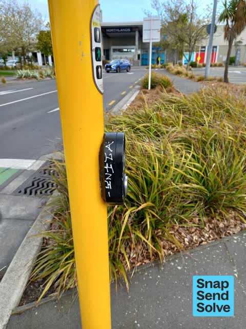
Graffiti on a traffic light pole or cabinet, or wa80 Main North Road
Pedestrian push button at traffic lights for entry to Northlands Mall is tagged on the side

Graffiti on a traffic light pole or cabinet, or wa22A Sawyers Arms Road
Sawyers Arms Rd, cnr Sisson Dr - traffic light control cabinet tagged

Graffiti on a fence, building or structurePapanui Domain Sawyers Arms Road
Papanui Domain entrance, opposite 56 Sawyers Arms Rd- backflow prevention box tagged
Reports per year up 23% 2024→2025
15
14
16
14
17
37
18
64
19
154
20
235
21
201
22
207
23
427
24
311
25
383
What gets reported
Exactly what people say
How fast the council fixes things here 4,293 finished jobs on record
The median council work order pinned in Northcote took 3 days to resolve, about the city-wide median (3 days). The slowest tenth waited 3 months or longer. 94 tickets are open here now, the oldest was filed 10 June 2019.
Work orders, not the resident reports above, the council’s MyCouncilTicket stream, and one job can appear in both. A median counts only finished jobs; open ones are named as open, never averaged in. The ticket roll · the whole city’s fix times.
Alcohol rules on this ground one ban zone reaches in
Papanui. A public drinking ban, seven nights a week from 6pm to 6am, covers about 27% of Northcote.
2 sensitive sites stand here, Marian College, St Josephs School, and the Local Alcohol Policy restricts new off-licences within 200 m of them.
The council’s bylaw zones and the Local Alcohol Policy’s buffer list, read from the Regulatory open-data service. A ban rules drinking in public places; it says nothing about whether a premises may sell, that is the licence register’s job.
The suburb today
Schools here 1
 Marian CollegeSecondary (Year 9-15) · decile 8 · EQI 426
Zoned for Casebrook Intermediate · Christchurch Adventist School · Emmanuel Christian School · Marian College · Middleton Grange School · Papanui High School · and 9 more zones, the drawn zone is indicative; the Ministry’s written scheme is the legal boundary.
Decile and EQI describe the community a school draws from, not how well it teaches.
The green here 5
- Papanui DomainSports ground · 3 ha · playground, 41 pieces
- Paddington Playground1 ha · playground, 25 pieces
- Craighead Reserve1 ha · playground, 35 pieces
- Morrison Avenue Bowling Clubplayground, 6 pieces
- Withers Family Park
Parks and reserves in the council’s open data, a park lands in the suburb its centre falls inside. The whole roll is at /parks.
Where the suburb worships 2
- Northcity Churcha church · 95a Sawyers Arms Road
- Papanui Baptist Churcha Baptist church · 144 Sawyers Arms Road
Places of worship in the open map’s record, one lands in the suburb its building stands in. The whole roll is at /worship.
The tracks through here 5
- Walk and bike track through Northcote1.9 km · Christchurch · walk · bike
- Walk and bike track through Northcote959 m · Christchurch · walk · bike
- Walk and bike track through Northcote809 m · Christchurch · walk · bike
- Walk and bike track through Northcote524 m · Christchurch · walk · bike
- Walk and bike track through Northcote321 m · Christchurch · walk · bike
Tracks in the council’s open data, a line belongs to every suburb it passes through. The whole network is at /tracks.
The ground that moved
The February 2011 survey drew mapped ground failure over 0.0% of this outline. A patch is a footprint, not a finding about an address; the count for the whole city is at /liquefaction.
The flood record drew water over 5.9% of this outline, about 7 hectares, across 1 named event. A patch is one event’s observation, not a live hazard finding; the whole record is drawn at /floods.
4 parcels inside this outline sit on the hazardous-activities register, mostly chemical manufacture, application and bulk storage, vehicle refuelling, service and repair, 3 still doing the work. A listing records the work, not a soil test; the whole register is drawn at /hazards.
The files record 18 parcels of made or characterised ground inside this outline, mostly topsoil, sawdust, silt, 1 carry fill the file can’t vouch for. A record is the file’s word on what was laid, not a fresh survey; the whole layer is drawn at /fill.
1 parcel inside this outline carries a cleanup on the file. A cleanup on the file is the register’s word, not a clearance; the whole register is drawn at /remediated.
The 2019 liquefaction study put 100% of this outline in the medium class. A class is the model’s verdict on a patch of ground, not a finding about an address; the whole study is drawn at /vulnerability.
The council’s structure register stands 3 assets on this ground, 2 ramps, 1 set of steps, sited at Papanui Domain, Withers Family Park. The register’s site names are its own labels for the ground an asset stands in; the layer is drawn at the map.
The recreation register keeps 11 records inside this outline, bookable surfaces for 6 softball, 2 basketball, 2 rugby league, 1 bmx. Seasons and surfaces are the register’s record, not this week’s draw; the layer is drawn at the map.
The register counts 486 living trees inside this outline, 14 veterans among them, 22 carrying a protection, mostly Midget Crab Apple, Manna Ash, Ribbonwood. The file remembers 130 trees felled here. A tree record is the register’s word on what stands or stood; the whole canopy is drawn at /trees.
The plan files 34% of this outline under Medium density residential zone, 60% residential, the rest mostly High density residential zone 15%, Industrial General 13%. A zone is a permission, not a description, the mix is read from a sampled join of the plan’s polygons; the whole district is drawn at /zones.
The plan reserves about 9 hectares of this outline, 7%, under 3 designations, mostly learning, movement. A designation is a claim on the ground, not a build date, the mix is read from a sampled join; the whole register is drawn at /designations.
The plan’s exceptions touch 10% of this outline, 8 qualifying matters, mostly residential, infrastructure, nps matter. A matter narrows how the density rule applies, it does not forbid; the mix is read from a sampled join, and the cultural-significance areas are the plan’s own unnamed ones. The whole register is drawn at /matters.
No high-hazard flood area covers this outline. The broader flood-management watch covers 59% of it, Lower Styx River. Shares read from a sampled join; a model’s map, not a promise. The waiting water is drawn at /flood-hazard.
The plan’s noise overlays cover all of this outline, about 124 hectares across 1 mapped overlay, and inside the airport’s bird-strike buffer. Shares read from a sampled join; a planning line, not a meter’s reading. The quiet lines are drawn at /noise.
The plan’s water-margin layers cross this outline, 23 classified reaches, the plan calling Kruses Drain and Sissons Drain by name, 5% of it inside the setback strips, the widest holding 10 m off the bank. The margin is the plan’s drawing, not a survey of the bank; the reaches, strips and held edges are mapped at /water-margin.
The plan’s allowed shape holds this outline, 49% of it inside the residential overlays, the densest standing Medium Density. The shape is the plan’s permission, not a survey of what stands; the allowed shape is drawn at /density.
The rebuild’s cameras filed 421 photographs on this ground, 2007–2015, wastewater work mostly. Each frame is a receipt the dig left behind, a work log, not a survey of what stands now; the whole record is drawn at /rebuild.
The pedal network threads this ground, 5.6 km of cycleway crosses the outline, 0.7 km of it separated from the traffic, Northern Line, Papanui Parallel. A segment counts under every suburb its path enters; the whole network is drawn at /cycleways.
The remembered names stand on this ground, 1 inscribed plaque, Morrison Avenue Bowling Club among the grounds. The plaque is the register’s pin, not a surveyed spot; the whole roll is kept at /plaques.
The rulebook binds this ground, 8 drawn instruments, 1 alcohol ban, 7 bottle-store buffers; the outline sits inside the takiwā of Te Ngai Tuahuriri Runanga. The bylaw is the instrument, this the map of it, the whole rulebook is drawn at /rules.
The crash record 108 injury crashes
108 crashes that hurt somebody on record inside Northcote's outline, 19 seriously hurt, nobody killed.
The corner that keeps appearing: Northcote Road at Uxbridge Street, 17 injury crashes.
The crime record 1,084 recorded victimisations
1,084 victimisations on the Police record inside Northcote’s outline, September 2022–August 2026, mostly theft, about 102 a year per 1,000 residents. Up 19% on the year before. Reported is not all, how much never reaches the record depends on the offence.
The buses through it 4 stops
4 Metro stops inside Northcote's outline, in ECan’s stop record, served by route 107.
- Northcote Rd near Fenchurch St
- Northcote Rd near Lydia St
- Northcote Rd near Uxbridge St near Northcote Rd
- Northcote Rd near Uxbridge St near Northcote Rd
Businesses here 164 in the directory
164 premises in Northcote across 44 kinds, from OpenStreetMap, the council’s licensed-premises register and its 2024 Find Christchurch directory. Each kind below opens at this suburb’s shelf.
- Clothing23
- Fast food19
- Restaurants17
- Cafés14
- Shoes9
- Hairdressers7
- Jewellery5
- Delis4
- Department stores4
- Electronics Repair4
- Gift shops4
- Opticians4
- Outdoor gear4
- Beauty3
- Cosmetics3
- Houseware3
- Phone shops3
- Banks2
- Car repair2
- Cinemas & theatres2
- Clubs2
- Massage2
- Stationery2
- Anime1
- ATMs1
- Bag1
- Bakeries1
- Bookshops1
- Car parts1
- Christmas1
- Company1
- Dentists1
- Food courts1
- Hairdresser Supply1
- Health Food1
- Ice cream1
- Laundromats1
- Malls1
- Pharmacies1
- Printers & copy shops1
- Sports shops1
- Supermarkets1
- Tailors1
- Travel agents1
Among them, the ones the record says most about:
Before any of that
Documents 40
What the archive’s sources say about Northcote, titled for it, turned up by a search for one of its places, or carrying its name in the text. These are leads and citations: the originals live at the provider, linked from each row.
41860s
61870s
251880s
271890s
511900s
311910s
261920s
141930s
561940s
21960s
672000s
472010s
82020s
News of the Week. [FROM THE DAILY TIMES.] (Otago Witness, 28 January 1865)
…occurrence a woman named margaret monogue who lived as servant at the house of mr hanslow northcote was taken into the hospiml it three oclock on thursday morning suffering from some very severe burns…Otago Witness · Papers Past · National Library of New Zealand · · text held
Local and General. (Star, 11 August 1868)
…trooper judge 28 trooper coombes 24 trooper mrittaij 25 trooper v brittan 12 band-mastjr northcote 10 j trooper all fry 8 tljo minimum number o poir i to ensure posscftslon of tho cup being 30 it sti…Star · Papers Past · National Library of New Zealand · · text held
Local and General. (Star, 22 September 1868)
…argets andthe following are the scores made cornet sice 22 sergeant coombes 30 baudmaster northcote 29 trooper judge 30 irooper prccce 27 and bandsman hammersley 1 3 the tie between coombes and judge…Star · Papers Past · National Library of New Zealand · · text held
Page 4 Advertisements Column 1 (Timaru Herald, 12 May 1869)
…kayner thomas ottery arowhenua leasehold ceased to possess i o thompson archibald mmurdo northcote freehold ceased to possess h thompson samuel geraldine leasehold ceased to possess o thomson andrew…Timaru Herald · Papers Past · National Library of New Zealand · · text held
Magisterial. (Star, 12 April 1870)
…gments were given for the following amounts w hobbs and sons v james reed 2 17b 6d same v northcote 3 16s to be paid at the rate of a 6d a week or one month imprisonment in default j h hopkins v j mco…Star · Papers Past · National Library of New Zealand · · text held
YESTERDAY. Loal and General. (Star, 14 January 1874)
…tion of it is derived from the suburbs of collingwood richmond prahran kew heidelberg and northcote over 1 which the city authorities can of course exercise no supervision for this reason the health c…Star · Papers Past · National Library of New Zealand · · text held
CHRISTCHURCH. (Star, 19 February 1874)
…5s anthony mlntyre one cow colombo streefc south fined 5s john mllroy two head of cattle northcote road avon district fined ss a w money two horses on tho ferry road fined os robert ball ono cow opaw…Star · Papers Past · National Library of New Zealand · · text held
THE Marlborough Express. (Marlborough Express, 01 May 1878)
…sir andrew 3 a special telegram from london m the post dated 16th april says sir stafford northcote speaking m parliament expressed himself sanguine of a paoiflc settlement of the eastern question bei…Marlborough Express · Papers Past · National Library of New Zealand · · text held
LATEST CABLE TELEGRAMS. (Hawke's Bay Herald, 08 June 1878)
…sts have been made lord salisbuy promises to pay attention to the armenians to which lord northcote referred in his despatches to lord salisbury indicating the policy of the congress reltkr tkmsgkams…Hawke's Bay Herald · Papers Past · National Library of New Zealand · · text held
The Akaroa Mail. TUESDAY, JUNE 18. (Akaroa Mail and Banks Peninsula Advertiser, 18 June 1878)
…tlas in the woildhas the following on municipal borrowing in the old country sir stafford northcote in his speech introducing the budget made some well-considered remarks which met with mr gladstone a…Akaroa Mail and Banks Peninsula Advertiser · Papers Past · National Library of New Zealand · · text held
The rest are a search away, the whole shelf, for the name →
The wire on Northcote 2 lately
Location: Canterbury Guns, ammunition, drugs and cash have been seized, and three King Cobra gang members have been arrested following a search at a Northcote, Christchurch property. Images(s):NZ Police · NZ Police ·
Something seen — Northcote Rd near Lydia St, Northcote, Christchurch 8052, New ZealandiNaturalist · thomas73675 ·
Next door
Compare Northcote with PAPANUI · Casebrook · Redwood · Bishopdale · Strowan · Bryndwr, same record, side by side.
Questions, answered briefly
What is Northcote?
Northcote is a suburb on the northern side of Christchurch, New Zealand. The public record holds 2,328 council reports for it, the first filed in July 2015.
How many people live in Northcote?
2,750 people at the 2023 Census, 2,210 per square kilometre across 1.2 km².
How many people does the 2023 Census count for Northcote?
About 2,667 people and 1,083 occupied private households: grouped from Stats NZ SA1 areas through this site’s suburb join. Indicative, not a LIM.
What gets reported in Northcote?
2,328 reports on record, most often graffiti & vandalism (754), rubbish & dumping (416), roads & footpaths (382). 401 of them in the year to 12 October 2026.
How many crashes has Northcote had?
108 injury crashes on the police record inside the suburb’s outline, 19 seriously hurt, nobody killed. The suburb’s crashes, mapped →
What schools are in Northcote?
One school in the Ministry’s directory, Marian College.
Every suburb in Christchurch → · Its decade, charted → · the whole A–Z →