The old university
Before it moved to Ilam, the university kept a whole campus on Hereford Street, the roll lists its chemistry, physics, biology and engineering blocks, its library, its quadrangles and its students' union, building by building. A campus walk the way Christ’s College is a school walk.
The walk, as a line
Straight between pins, the streets run longer. Every numbered pin opens that place’s own record.
The stops, in order
- West Lecture Block and Setting, 50 Rolleston Avenue · 44 unread leads
The West Lecture Block, the campus’s west door on Rolleston Avenue.
- Girls' High School/School of Art Block and Setting, 101/1 Hereford Street · 40 unread leads
The Girls' High / School of Art block, the street’s first entry.
- Chemistry Building and Setting, 3/5 Hereford Street · 41 unread leads
The Chemistry building.
- Library and Setting, 13 Hereford Street · 60 unread leads
The Library.
- North and South Quadrangles and Setting, 13 Hereford Street · 40 unread leads
The North and South Quadrangles, the ground between the buildings is listed too.
- Electrical Engineering Laboratory, School of Engineering, and Setting, 13 Hereford Street · 40 unread leads
The Electrical Engineering laboratory.
- Men's Common Room and Setting, 7 Hereford Street · 42 unread leads
The Men’s Common Room.
- Biology and Observatory Block and Setting, 7 Hereford Street · 24 unread leads
The Biology and Observatory block.
- Physics Building and Setting, 7 Hereford Street · 42 unread leads
The Physics building.
- Electrical Engineering Extension, School of Engineering, and Setting, 15 Hereford Street · 40 unread leads
The Electrical Engineering extension, the school’s second entry.
- Students' Union and Setting, 39 Hereford Street · 41 unread leads
The Students' Union, the last of the campus’s own.
- Mill Island and Setting, 71 Hereford Street · 40 unread leads
Mill Island, a step east, where the campus met the river.
What the register built on the way
Council structures within about 30 m of the stop-to-stop line, the bridges, steps and shelters the route passes. Site names are the register’s own.
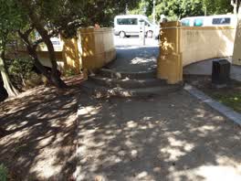 A set of steps at Avon Riverbank Central City, 3 steps · built 1899 10 m off the line
The reports along it
5,493 council reports pinned within 150 m of the line, most often Graffiti & vandalism and Roads & footpaths, 4,526 with a photograph. A pin is where a reporter stood, not a claim about the place itself.
 Pavement - General
 Pavement - Damaged
 Pavement - Damaged
 Graffiti on a fence, building or structure
 Hazard, vehicle
 Graffiti on a bus stop or public toilet
 Hazard, vehicle
 Graffiti on a fence, building or structure
 Graffiti on a fence, building or structure
 Graffiti on a fence, building or structure
 Graffiti on a fence, building or structure
 Graffiti on a sign, mural or public art
Questions, answered briefly
Before it moved to Ilam, the university kept a whole campus on Hereford Street, the roll lists its chemistry, physics, biology and engineering blocks, its library, its quadrangles and its students' union, building by building. 12 listed places, 0.6 km as the line runs, Christchurch Central City.
West Lecture Block and Setting (50 Rolleston Avenue) to Mill Island and Setting (71 Hereford Street), the order is a suggestion, not the only way round.
Every one, each pin is a row in the district plan’s heritage schedule, and each opens the place’s own sourced record here.
0.6 km measured straight between the pins, the streets run longer, and the stops deserve a pause each.
The record behind this
Every stop is a row in the district plan’s heritage schedule, held here as the register’s own layer. The order and the notes are ours, the listings are the council’s and Heritage New Zealand’s. "Setting" is the register’s word for the ground a listing covers.
The rest of the register here: Central City
The same ground today: Christchurch Central City
More walks over this ground: The square and its ring · The boulevard · The river bend · The school’s own register · The city’s stones · Belfries and chapels · The old high street
This page as markdown: /walks/the-old-varsity.md · the route as data: /walks/the-old-varsity.geojson · on the live map: the walks layer.