150 Kilmore Street, Christchurch Central City
11 reports on record since November 2021 · 8 with photographs. The street’s heaviest record is 70 Kilmore Street — 86 reports on file. Indicative rating valuation and school zones, hazards, bin day and what stood here before.
What gets reported here
Photographed here 8 on record


Reported here
 Water Leak —
Burst pipe
 Graffiti on a fence, building or structure —
 Graffiti on a fence, building or structure —
150 Kilmore St, just west of Manchester corner (south side) - possibly Chorus cabinet
 Graffiti on a cabinet, pole or railway asset —
Traffic lights
 Street Cleaning —
Broken glass
 Dumped Rubbish —
For the last few weeks people have been camping in the carpatk in front of our community garden and leaving rubbish everywhere we bagged mo
- Graffiti —
- Graffiti —
- Graffiti —
 Graffiti —
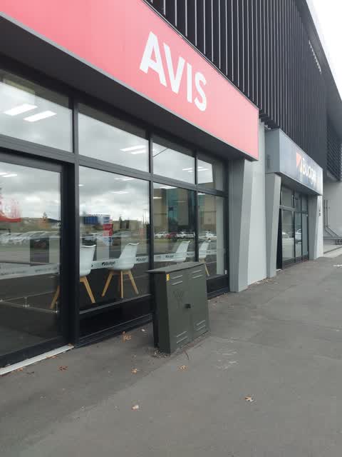
FYC tag on green box ID CHAH Outside Avis car rentals on Kilmore St
 Graffiti —
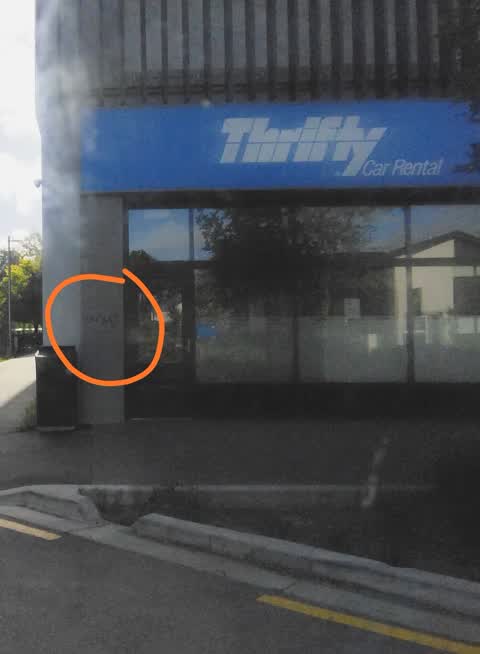
On wall next to thrift car rental. Black graffiti
Also reported on Kilmore Street
- 70 Kilmore Street — 86 reports
- 211 Kilmore Street — 72 reports
- 294E Kilmore Street — 53 reports
- 277 Kilmore Street — 49 reports
- 254 Kilmore Street — 42 reports
- 86 Kilmore Street — 30 reports
- 284 Kilmore Street — 29 reports
- 229 Kilmore Street — 28 reports
The street’s crash record
NZTA’s record names Kilmore Street in 104 crashes that hurt somebody since 2006 — 1 person killed, 22 seriously hurt.
The green nearby
- Edmonds Band Rotunda — 112 m to the edge · Botanic
- Cambridge Reserve — 185 m to the edge
- Poplars Reserve — 205 m to the edge · Botanic
- Victoria Square — 244 m to the edge · Botanic · 2 ha
- Fire Fighters Reserve — 270 m to the edge
Parks within half a kilometre, measured to the boundary — the council’s open data.
The civic shelf nearby
- Turanga Library — 418 m away · Library · Cathedral Square, Christchurch
Libraries, halls and the rest within half a kilometre — the council’s open data.
On the doorstep
- Forte 2 — 92 m away · Doctors & clinics
- Southern Eye Speicalists — 131 m away · Doctors & clinics
- Urology Associates — 134 m away · Doctors & clinics
- Saunders Robinson Brown — 135 m away · Lawyers
Businesses within four hundred metres, measured at the pin — OpenStreetMap and the council directories.
The bus nearby
- Manchester St near Kilmore St — 28 m away · route 44, route 91, route 92
- Manchester St near Kilmore St — 62 m away · route 1, route 27, route 29, route 44, route 91, route 92, route 95
The closest Metro stops, within four hundred and fifty metres.
The tracks through here
- Walk and bike track through Christchurch Central City — 16 m to the line · walk · bike
- Walk and bike track through Christchurch Central City — 164 m to the line · walk · bike
- Walk and bike track through Christchurch Central City — 226 m to the line · walk · bike
- Walk and bike track through Christchurch Central City — 259 m to the line · walk · bike
- Walk and bike track through Christchurch Central City — 260 m to the line · walk · bike
Tracks whose line passes within half a kilometre, measured to the line itself — the council’s open data.
The named ground
Named water within 500 m of this address, measured to the line or the edge; Named places within 1.5 km of this address; the council’s own structure register — bridges, boardwalks and steps standing nearby — the open map’s record.
The remembered names nearby
- This Rotunda Shelter and Circular Seat Were Presented — 131 m away ·
THIS ROTUNDA SHELTER AND CIRCULAR SEAT WERE PRESENTED BY T.J. EDMONDS TO CELEBRATE FIFTY Y
· 2009 - Poplar Crescent 1929 — 139 m away ·
POPLAR CRESCENT 1929
· 2009 - Scottish Pioneer Tribute — 198 m away ·
SCOTTISH PIONEER TRIBUTE / This plaque celebrates and pays tribute to the Scottish Pioneer
Inscribed plaques within two hundred and fifty metres — the register’s pins, not surveyed spots. The whole roll is at /plaques.
Renting nearby
new bonds in Christchurch Central City ran about $508 a week — $42 below the city median of $550 — the suburb page keeps the rent record →.
What was here — Former Church of St Luke the Evangelist Bell Tower and Setting
69 m away · 258 Manchester Street · located to ±4 m · the place’s own record →
On the register. Nothing researched here yet.
What was here — Former Vicarage of the Church of St Luke the Evangelist and Setting
110 m away · 185 Kilmore Street · located to ±12 m · the place’s own record →
On the register. Nothing researched here yet.
What was here — Edmonds Band Rotunda Area including Rotunda, Shelter, Balustrades, Landing and Lamp Standards and Setting
137 m away · 230 Cambridge Terrace · located to ±57 m · the place’s own record →
On the register. Nothing researched here yet.
What was here — Poplars, Lamp Standards and Setting
163 m away · located to ±139 m · the place’s own record →
On the register. Nothing researched here yet.
What was here — Colombo Street Bridge and Setting
230 m away · located to ±24 m · the place’s own record →
On the register. Nothing researched here yet.
The civic layer
This ground votes in Central ward — the Papanui-Innes-Central community board. Ward lines don’t always follow suburb lines; this one is measured at the pin, not the suburb’s centre.
What stood on this ground → · On the map → · From the air — the Crown’s aerials back to 1936; search the address on RetroLens →
Questions, answered briefly
11 council reports on record since November 2021 — most often graffiti (5), graffiti on a fence, building or structure (2), water leak (1).
Christchurch Central City, Christchurch — on Kilmore Street.
The heritage register names 5 places at or beside it — Former Church of St Luke the Evangelist Bell Tower and Setting, Former Vicarage of the Church of St Luke the Evangelist and Setting.
Edmonds Band Rotunda — 112 m to its edge.