185 Kilmore Street, Christchurch Central City
12 reports on record since December 2022 · 5 with photographs. The street’s heaviest record is 70 Kilmore Street — 86 reports on file. Indicative rating valuation and school zones, hazards, bin day and what stood here before.
What gets reported here
Photographed here 5 on record



Reported here
 Dumped Rubbish —
I keep on finding people staying at the short term accommodation next door to us using our bins. I’ve had the yellow bin declined recently
 Dumped Rubbish —
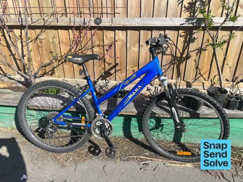
Bike abandoned in my garden
- Noise - General —
Last night the alarm at the Airbnb at 173 Kilmore street was going off at 2 am for over half an hour. I was too tired to call noise control.
 Graffiti somewhere else —
 Graffiti somewhere else —
 Graffiti on a fence, building or structure —
Graffiti on heritage listed building
- Graffiti —
- Graffiti —
- Vandalism - General —
- Animal - General —
- Damaged Street Sign —
- Graffiti —
Also reported on Kilmore Street
- 70 Kilmore Street — 86 reports
- 211 Kilmore Street — 72 reports
- 294E Kilmore Street — 53 reports
- 277 Kilmore Street — 49 reports
- 254 Kilmore Street — 42 reports
- 86 Kilmore Street — 30 reports
- 284 Kilmore Street — 29 reports
- 229 Kilmore Street — 28 reports
The street’s crash record
NZTA’s record names Kilmore Street in 104 crashes that hurt somebody since 2006 — 1 person killed, 22 seriously hurt.
The green nearby
- Cambridge Reserve — 101 m to the edge
- Poplars Reserve — 162 m to the edge · Botanic
- Edmonds Band Rotunda — 174 m to the edge · Botanic
- Fire Fighters Reserve — 190 m to the edge
- Victoria Square — 341 m to the edge · Botanic · 2 ha
Parks within half a kilometre, measured to the boundary — the council’s open data.
The civic shelf nearby
- Turanga Library — 496 m away · Library · Cathedral Square, Christchurch
Libraries, halls and the rest within half a kilometre — the council’s open data.
On the doorstep
- Knit World — 141 m away · Wool
- Mainland Uniforms — 146 m away · Clothing
- South Architects — 157 m away · Architects
- Fox and Associates — 163 m away · Surveyors
Businesses within four hundred metres, measured at the pin — OpenStreetMap and the council directories.
The bus nearby
- Manchester St near Kilmore St — 68 m away · route 1, route 27, route 29, route 44, route 91, route 92, route 95
- Manchester St near Kilmore St — 77 m away · route 44, route 91, route 92
The closest Metro stops, within four hundred and fifty metres.
The tracks through here
- Walk and bike track through Christchurch Central City — 74 m to the line · walk · bike
- Walk and bike track through Christchurch Central City — 159 m to the line · walk · bike
- Walk and bike track through Christchurch Central City — 171 m to the line · walk · bike
- Walk and bike track through Christchurch Central City — 174 m to the line · walk · bike
- Walk and bike track through Christchurch Central City — 206 m to the line · walk · bike
Tracks whose line passes within half a kilometre, measured to the line itself — the council’s open data.
The named ground
Named water within 500 m of this address, measured to the line or the edge; Named places within 1.5 km of this address; the council’s own structure register — bridges, boardwalks and steps standing nearby — the open map’s record.
The remembered names nearby
- These Trees Were Planted by / Past Presidents — 139 m away ·
THESE TREES WERE PLANTED BY / PAST PRESIDENTS OF / NATIONAL COUNCIL OF WOMEN / CHRISTCHURC
· 2009 - Planted by the / Canterbury Provincial [] / to Commemorate — 140 m away ·
PLANTED BY THE / CANTERBURY PROVINCIAL [illegible] / TO COMMEMORATE / THE GOLDEN JUBILEE /
· 2009 - 25th May 1991 / 25 Years in New Zealand Working — 143 m away ·
25th May 1991 / 25 years in New Zealand working / for prisoners of conscience and / politi
· 2009
Inscribed plaques within two hundred and fifty metres — the register’s pins, not surveyed spots. The whole roll is at /plaques.
Renting nearby
new bonds in Christchurch Central City ran about $508 a week — $42 below the city median of $550 — the suburb page keeps the rent record →.
What was here — Former Vicarage of the Church of St Luke the Evangelist and Setting
14 m away · 185 Kilmore Street · located to ±12 m · the place’s own record →
On the register. Nothing researched here yet.
What was here — Former Church of St Luke the Evangelist Bell Tower and Setting
64 m away · 258 Manchester Street · located to ±4 m · the place’s own record →
On the register. Nothing researched here yet.
What was here — Poplars, Lamp Standards and Setting
on this spot · located to ±139 m · the place’s own record →
On the register. Nothing researched here yet.
What was here — Edmonds Clock Tower, Telephone Cabinet and Setting
191 m away · 295F Madras Street · located to ±15 m · the place’s own record →
On the register. Nothing researched here yet.
What was here — Edmonds Band Rotunda Area including Rotunda, Shelter, Balustrades, Landing and Lamp Standards and Setting
217 m away · 230 Cambridge Terrace · located to ±57 m · the place’s own record →
On the register. Nothing researched here yet.
The civic layer
This ground votes in Central ward — the Papanui-Innes-Central community board. Ward lines don’t always follow suburb lines; this one is measured at the pin, not the suburb’s centre.
What stood on this ground → · On the map → · From the air — the Crown’s aerials back to 1936; search the address on RetroLens →
Questions, answered briefly
12 council reports on record since December 2022 — most often graffiti (3), graffiti somewhere else (2), dumped rubbish (2).
Christchurch Central City, Christchurch — on Kilmore Street.
The heritage register names 5 places at or beside it — Former Vicarage of the Church of St Luke the Evangelist and Setting, Former Church of St Luke the Evangelist Bell Tower and Setting.
Cambridge Reserve — 101 m to its edge.